EskDale, Utah
| EskDale, Utah | |
|---|---|
| Unincorporated community | |
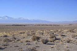 View of Eskdale from the east, December 2009 | |
 Eskdale Location of Eskdale within the State of Utah  Eskdale Eskdale (the US) | |
| Coordinates: 39°06′26″N 113°57′09″W / 39.10722°N 113.95250°WCoordinates: 39°06′26″N 113°57′09″W / 39.10722°N 113.95250°W | |
| Country | United States |
| State | Utah |
| County | Millard |
| Founded | 1955 |
| Named for | River Esk |
| Elevation[1] | 4,984 ft (1,519 m) |
| Time zone | UTC-7 (Mountain (MST)) |
| • Summer (DST) | UTC-6 (MDT) |
| ZIP code | 84728 |
| Area code(s) | 435 |
| GNIS feature ID | 1427841[1] |
Eskdale (sometimes written as EskDale) is a small unincorporated community in western Millard County, Utah, United States, just east of the Nevada border.[1]
Description
The community is a farming commune and is located in the southern part of Snake Valley, near the western flank of the Conger Range (part of the larger Confusion Range).[2] It was founded in 1955 by Dr. M. L. Glendenning as a religious community of the House of Aaron. The name itself comes from the River Esk in Scotland.[3]
The town is home to EskDale High School, which serves the communities of Eskdale, Garrsion, Bubank, and Baker (Nevada), along with other locals in the Snake Valley area. Eskdale is also known for its dairy.
See also
![]()
References
- 1 2 3 "Eskdale". Geographic Names Information System. United States Geological Survey.
- ↑ "MyTopo Maps - Eskdale, UT, USA" (Map). mytopo.com. Trimble Navigation, Ltd. Retrieved 11 Feb 2018.
- ↑ Van Cott, John W. (1990). Utah Place Names: A Comprehensive Guide to the Origins of Geographic Names: A Compilation. Salt Lake City: University of Utah Press. p. 131. ISBN 978-0-87480-345-7. OCLC 797284427. Retrieved 9 Feb 2018.
External links
Places adjacent to EskDale, Utah | ||||||||||
|---|---|---|---|---|---|---|---|---|---|---|
| ||||||||||
Municipalities and communities of Millard County, Utah, United States | ||
|---|---|---|
| Cities | 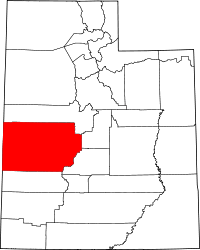 | |
| Towns | ||
| CDPs | ||
| Unincorporated communities | ||
| Ghost towns | ||
| Indian reservation | ||
| Footnotes | ‡This populated place also has portions in an adjacent county or counties | |
This article is issued from
Wikipedia.
The text is licensed under Creative Commons - Attribution - Sharealike.
Additional terms may apply for the media files.