National Register of Historic Places listings in Wayne County, Utah
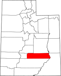
Location of Wayne County in Utah
This is a list of the National Register of Historic Places listings in Wayne County, Utah.
This is intended to be a complete list of the properties and districts on the National Register of Historic Places in Wayne County, Utah, United States. Latitude and longitude coordinates are provided for many National Register properties and districts; these locations may be seen together in a map.[1]
There are 21 properties and districts listed on the National Register in the county. One other site in the county was once listed, but has since been removed.
- This National Park Service list is complete through NPS recent listings posted October 11, 2018.[2]
Current listings
| [3] | Name on the Register[4] | Image | Date listed[5] | Location | City or town | Description |
|---|---|---|---|---|---|---|
| 1 | Elijah Cutler Behunin Cabin | 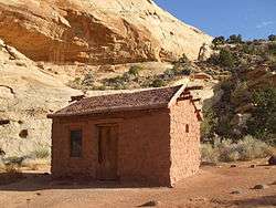 |
September 13, 1999 (#99001094) |
State Route 24, 1.5 miles (2.4 km) southeast of the tip of Horse Mesa 38°16′56″N 111°10′12″W / 38.282222°N 111.17°W |
Torrey | |
| 2 | Bull Creek Archeological District | April 30, 1981 (#81000586) |
Address Restricted[6] |
Hanksville | ||
| 3 | Cathedral Valley Corral | 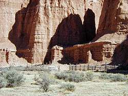 |
September 13, 1999 (#99001093) |
Middle Desert, southeast of the confluence of Cathedral Mountain and Cathedral Valley 38°29′05″N 111°20′58″W / 38.484722°N 111.349444°W |
Torrey | |
| 4 | Civilian Conservation Corps Powder Magazine | 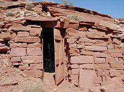 |
September 13, 1999 (#99001090) |
South of the Fremont River, north of Cuts Canyon 38°16′33″N 111°15′04″W / 38.275833°N 111.251111°W |
Torrey | |
| 5 | Cowboy Caves | August 27, 1980 (#80003993) |
Address Restricted[6] |
Green River | ||
| 6 | D.C.C. & P. Inscription "B" | October 7, 1988 (#88001251) |
Confluence vicinity 38°11′17″N 109°53′12″W / 38.188056°N 109.886667°W |
Moab | ||
| 7 | Fruita Rural Historic District | 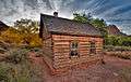 |
March 25, 1997 (#97000246) |
Roughly along State Route 24 from Sulphur Creek to Hickman Natural Bridge 38°17′06″N 111°15′07″W / 38.285°N 111.251944°W |
Fruita | |
| 8 | Fruita Schoolhouse | 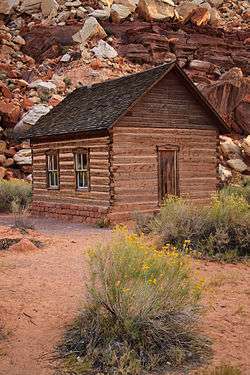 |
February 23, 1972 (#72000098) |
Capitol Reef National Park on State Route 24 38°17′17″N 111°14′54″W / 38.2881°N 111.2482°W |
Fruita | |
| 9 | Grover School | 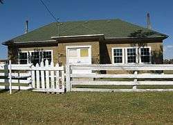 |
April 9, 1986 (#86000753) |
W. 100 North St. 38°13′47″N 111°21′02″W / 38.229722°N 111.350556°W |
Grover | |
| 10 | Hanks' Dugouts | September 13, 1999 (#99001095) |
Confluence of Pleasant Creek and South Draw 38°10′39″N 111°11′03″W / 38.1775°N 111.184167°W |
Torrey | ||
| 11 | Hanksville Meetinghouse-School | December 18, 1990 (#90001825) |
100 S. Center St. 38°22′21″N 110°42′51″W / 38.3725°N 110.714167°W |
Hanksville | ||
| 12 | Harvest Scene Pictograph | April 1, 1975 (#75000241) |
Address Restricted[6] |
Green River | ||
| 13 | Horseshoe Canyon Archeological District | 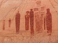 |
February 23, 1972 (#72000099) |
Horseshoe Canyon Detached Unit, Canyonlands National Park Coordinates missing |
Green River and Hanksville | Originally listed as "Horseshoe (Barrier Canyon Pictograph Panels" with a restricted address; current address represents the Archeological District boundary increase of January 24, 2012 (#11001044) |
| 14 | Charles W. and Leah Lee House | 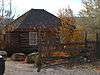 |
November 15, 1996 (#96001325) |
277 W. 100 North 38°18′02″N 111°25′33″W / 38.300556°N 111.425833°W |
Torrey | |
| 15 | Loa Tithing Office | 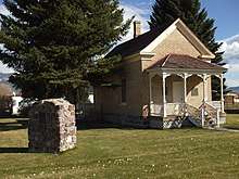 |
March 28, 1985 (#85000687) |
100 West and Center St. 38°24′07″N 111°38′38″W / 38.401944°N 111.643889°W |
Loa | |
| 16 | Lesley Morrell Line Cabin and Corral | 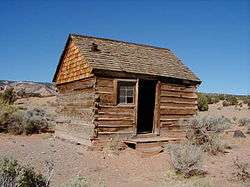 |
September 13, 1999 (#99001096) |
Confluence of Middle Desert Wash and Cathedral Valley 38°29′02″N 111°21′55″W / 38.483889°N 111.365278°W |
Torrey | |
| 17 | Hans Peter Nielson Gristmill | 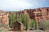 |
June 18, 1975 (#75001835) |
3 miles (4.8 km) southeast of Bicknell 38°18′29″N 111°30′38″W / 38.308056°N 111.510556°W |
Bicknell | |
| 18 | Oyler Mine | 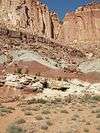 |
September 14, 1999 (#99001092) |
Confluence of Grand Wash and Cohab Canyon 38°15′33″N 111°13′51″W / 38.259167°N 111.230833°W |
Torrey | |
| 19 | Pioneer Register | 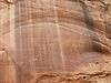 |
September 13, 1999 (#99001097) |
Southwest of the confluence of Capitol Wash and Waterpocket Canyon 38°12′41″N 111°09′36″W / 38.211389°N 111.16°W |
Torrey | |
| 20 | Teasdale Tithing Granary | 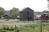 |
March 28, 1985 (#85000688) |
Off State Route 117 38°17′03″N 111°28′26″W / 38.284167°N 111.473889°W |
Teasdale | |
| 21 | Torrey Log Church-Schoolhouse | 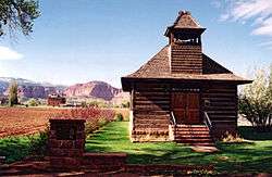 |
May 14, 1993 (#93000411) |
Approximately 49 E. Main St. 38°17′57″N 111°25′10″W / 38.299167°N 111.419444°W |
Torrey |
Former listing
| [3] | Name on the Register | Image | Date listed | Date removed | Location | City or town | Summary |
|---|---|---|---|---|---|---|---|
| 1 | Wayne County High School | April 1, 1985 (#85000821) | December 4, 1991 | 55 N. Center St. 38°20′30″N 111°32′40″W / 38.3417°N 111.5444°W |
Bicknell |
See also
References
- ↑ The latitude and longitude information provided in this table was derived originally from the National Register Information System, which has been found to be fairly accurate for about 99% of listings. For about 1% of NRIS original coordinates, experience has shown that one or both coordinates are typos or otherwise extremely far off; some corrections may have been made. A more subtle problem causes many locations to be off by up to 150 yards, depending on location in the country: most NRIS coordinates were derived from tracing out latitude and longitudes from USGS topographical quadrant maps created under the North American Datum of 1927, which differs from the current, highly accurate WGS84 GPS system used by most on-line maps. Chicago is about right, but NRIS longitudes in Washington are higher by about 4.5 seconds, and are lower by about 2.0 seconds in Maine. Latitudes differ by about 1.0 second in Florida. Some locations in this table may have been corrected to current GPS standards.
- ↑ "National Register of Historic Places: Weekly List Actions". National Park Service, United States Department of the Interior. Retrieved on October 11, 2018.
- 1 2 Numbers represent an ordering by significant words. Various colorings, defined here, differentiate National Historic Landmarks and historic districts from other NRHP buildings, structures, sites or objects.
- ↑ National Park Service (2008-04-24). "National Register Information System". National Register of Historic Places. National Park Service.
- ↑ The eight-digit number below each date is the number assigned to each location in the National Register Information System database, which can be viewed by clicking the number.
- 1 2 3 Some listings on the NRHP are highly sensitive sites and may be subject to looting or vandalism. The NRHP lists this site as "Address Restricted."
External links
![]()
 |  | ||
| Topics | |
|---|---|
| Lists by states |
|
| Lists by insular areas | |
| Lists by associated states | |
| Other areas | |
| |
Municipalities and communities of Wayne County, Utah, United States | ||
|---|---|---|
| Towns | | |
| CDPs | ||
| Unincorporated communities | ||
| Ghost towns | ||
This article is issued from
Wikipedia.
The text is licensed under Creative Commons - Attribution - Sharealike.
Additional terms may apply for the media files.