Border, Utah
| Border, Utah | |
|---|---|
| Unincorporated community | |
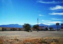 Motel in Border, October 2007 | |
| Etymology: Nevada-Utah border | |
 Border, Utah Location of Border within the State of Utah | |
| Coordinates: 39°03′24″N 114°02′57″W / 39.05667°N 114.04917°WCoordinates: 39°03′24″N 114°02′57″W / 39.05667°N 114.04917°W | |
| Country | United States |
| State | Utah |
| County | Millard County |
| Time zone | UTC-7 (Mountain (MST)) |
| • Summer (DST) | UTC-6 (MDT) |
| ZIP code | 84728 |
Border is an unincorporated community on the western edge of Millard County, Utah, United States, on the Nevada state line. The community is located 88 miles (142 km) west of Delta, Utah and 64 miles (103 km) east of Ely, Nevada.[1][2]U.S. Route 6/U.S. Route 50 passes through the community.
See also
![]()
References
- ↑ Carlisle, Nate (21 Jan 2006). "Sheepherders gather to spin yarns: Border Inn's annual get-together a big hit with range workers". The Salt Lake Tribune. Salt Lake City: Huntsman Family Investments, LLC. Retrieved 2 Feb 2018.
- ↑ Draper, Dean (26 Jan 2006). "Sheepherders flock to party on West Desert". greatbasinheritage.org. Archived from the original on 4 Jul 2007. Retrieved 2 Feb 2018 – via web.archive.org.
External links
![]()
Municipalities and communities of Millard County, Utah, United States | ||
|---|---|---|
| Cities | 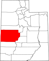 | |
| Towns | ||
| CDPs | ||
| Unincorporated communities | ||
| Ghost towns | ||
| Indian reservation | ||
| Footnotes | ‡This populated place also has portions in an adjacent county or counties | |
This article is issued from
Wikipedia.
The text is licensed under Creative Commons - Attribution - Sharealike.
Additional terms may apply for the media files.