Sullivan, New York
- There is also a Sullivan County in New York.
Coordinates: 43°4′N 75°52′W / 43.067°N 75.867°W
| Sullivan, New York | |
|---|---|
| Town | |
 Sullivan Free Library | |
 Sullivan, New York Location within the state of New York | |
| Coordinates: 43°4′N 75°52′W / 43.067°N 75.867°W | |
| Country | United States |
| State | New York |
| County | Madison |
| Government | |
| • Type | Town Council |
| • Town Supervisor | John M. Becker (R) |
| • Town Council |
Members' List
|
| Area[1] | |
| • Total | 73.35 sq mi (189.96 km2) |
| • Land | 73.15 sq mi (189.45 km2) |
| • Water | 0.20 sq mi (0.52 km2) |
| Elevation | 410 ft (120 m) |
| Population (2010) | |
| • Total | 15,339 |
| • Estimate (2016)[2] | 15,225 |
| • Density | 208.14/sq mi (80.36/km2) |
| Time zone | UTC-5 (Eastern (EST)) |
| • Summer (DST) | UTC-4 (EDT) |
| ZIP code | 13030, 13037 |
| Area code(s) | 315 |
| FIPS code | 36-053-71993 |
| GNIS feature ID | 0979535 |
| Website | Town of Sullivan government site |
Sullivan is a town in Madison County, New York, United States. The population was 15,339 at the 2010 census. The town is named after General John Sullivan.
The Town of Sullivan is located in the northwest corner of the county.
History
Settlement began around 1790. The town was established in 1803 from the Town of Cazenovia. In 1809, the town was partitioned to form the Town of Lenox.
The Chittenango Landing Dry Dock Complex was listed on the National Register of Historic Places in 1992.[3]
Geography
According to the United States Census Bureau, the town has a total area of 73.6 square miles (190.5 km²), of which, 73.4 square miles (190.0 km²) is land and 0.2 square miles (0.5 km²) (0.27%) is water.
The northern border of the town is Oneida Lake, and the west border is the Chittenango Creek.
The New York State Thruway (Interstate 90) passes across the town.
Demographics
| Historical population | |||
|---|---|---|---|
| Census | Pop. | %± | |
| 1820 | 2,932 | — | |
| 1830 | 4,077 | 39.1% | |
| 1840 | 4,390 | 7.7% | |
| 1850 | 4,764 | 8.5% | |
| 1860 | 5,233 | 9.8% | |
| 1870 | 4,921 | −6.0% | |
| 1880 | 4,803 | −2.4% | |
| 1890 | 4,046 | −15.8% | |
| 1900 | 3,778 | −6.6% | |
| 1910 | 3,367 | −10.9% | |
| 1920 | 3,002 | −10.8% | |
| 1930 | 3,383 | 12.7% | |
| 1940 | 3,775 | 11.6% | |
| 1950 | 4,905 | 29.9% | |
| 1960 | 9,369 | 91.0% | |
| 1970 | 11,969 | 27.8% | |
| 1980 | 13,371 | 11.7% | |
| 1990 | 14,622 | 9.4% | |
| 2000 | 14,991 | 2.5% | |
| 2010 | 15,339 | 2.3% | |
| Est. 2016 | 15,225 | [2] | −0.7% |
| U.S. Decennial Census[4] | |||
At the 2000 census,[5] there were 14,991 people, 5,688 households and 4,169 families residing in the town. The population density was 204.3 per square mile (78.9/km²). There were 6,209 housing units at an average density of 84.6 per square mile (32.7/km²). The racial makeup of the town was 98.25% White, 0.33% African American, 0.36% Native American, 0.23% Asian, 0.13% from other races, and 0.71% from two or more races. Hispanic or Latino of any race were 0.54% of the population.
There were 5,688 households of which 35.6% had children under the age of 18 living with them, 57.9% were married couples living together, 10.7% had a female householder with no husband present, and 26.7% were non-families. 21.0% of all households were made up of individuals and 7.6% had someone living alone who was 65 years of age or older. The average household size was 2.62 and the average family size was 3.03.
27.1% of the population were under the age of 18, 6.2% from 18 to 24, 30.3% from 25 to 44, 25.3% from 45 to 64, and 11.1% who were 65 years of age or older. The median age was 38 years. For every 100 females, there were 95.9 males. For every 100 females age 18 and over, there were 94.5 males.
The median household income was $44,468 and the median family income was $50,262. Males had a median income of $36,587 and females $25,881. The per capita income was $20,982. About 4.8% of families and 7.0% of the population were below the poverty line, including 6.8% of those under age 18 and 7.6% of those age 65 or over.
Communities and locations in Sullivan
- Blakeslea – A hamlet in the southeast corner of the town.
- Bolivar – A hamlet northeast of Chittenango village.
- Bridgeport – A hamlet in the northwest of the town by the town line on NY-31 at the Chittenango Creek.
- Chittenango – The Village of Chittanango and the location of the town government is in the south part of the town.
- Chittenango Creek – A stream that forms the northwest boundary of the town.
- Chittenango Springs – A hamlet south of Chittenango village on Route 13.
- East Boston – A location near the east town line.
- Eaton Corners – A location south of Lakeport.
- Fyler Settlement – a hamlet in the northwest part of the town.
- Gees Corner – A location in the northeast part of the town.
- Lake Oneida Beach West – A lakeside hamlet on the shore of Oneida Lake.
- Lakeport – A hamlet on Oneida Lake and Route 31.
- Messenger Bay – A lakeside hamlet in the northeast corner of the town.
- North Chittenango – A hamlet south of the Thruway on Lakeport Road.
- Oneida Lake Beach West – A lakeside hamlet in the north part of the town. The Oneida Lake Congregational Church was listed on the National Register of Historic Places in 2006.[3]
- Peck Corner – A location in the northwest part of the town at County Routes 1 and 4.
- Sullivan – A hamlet east of Chittenango village on Route 5 and 13.
- Weaver Corner – A location near Chittenango Creek in the northwest part of the town.
Transportation
Luther Airport is located one nautical mile (1.85 km) east of the central business district of Chittenango.[6]
Notable residents
- Augustus and John Allen, founders of Houston, Texas[7]
Gallery
.jpg)
.jpg)
.jpg)
.jpg)
.jpg)
See also
References
- ↑ "2016 U.S. Gazetteer Files". United States Census Bureau. Retrieved Jul 5, 2017.
- 1 2 "Population and Housing Unit Estimates". Retrieved June 9, 2017.
- 1 2 National Park Service (2009-03-13). "National Register Information System". National Register of Historic Places. National Park Service.
- ↑ "Census of Population and Housing". Census.gov. Retrieved June 4, 2015.
- ↑ "American FactFinder". United States Census Bureau. Retrieved January 31, 2008.
- ↑ "FAA Airport Master Record". Federal Aviation Administration. 8 April 2010. Archived from the original (PDF) on 22 October 2012. .
- ↑ "Historical Marker Detail for Allen, John Kirby, (1810 - 1838) Co-Founder of Houston". Houston, Texas: Harris County Historical Commission. Retrieved 2012-08-31.
Per the research of Allen descendant, Ralph Dittman, John Kirby Allen was born in Canaseraga Village, Madison County, New York. This is not the same location as the contemporary Canaseraga in Allegany County, New York. The Village of Canaseraga in now Sullivan Village. Canasareaugh, ending with "areaugh", is a misspelling of the village name. In an interview given to the Houston Daily Post in 1895 Charlotte Baldwin Allen refers to his birthplace as Orrville. Charlotte Allen was 90 years of age at the time of the Houston Daily Post interview, and died the following month. Dittman's research indicates that John Kirby moved to Orrville at the age of seven to live with an uncle. Orrville was renamed DeWitt in 1825.
| Wikimedia Commons has media related to Sullivan, New York. |
External links
Municipalities and communities of Madison County, New York, United States | ||
|---|---|---|
| City | 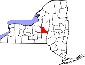 | |
| Towns | ||
| Villages | ||
| CDP | ||
| Other hamlets | ||
| Indian reservations | ||
| Footnotes | ‡This populated place also has portions in another county or counties | |