| [2] |
Name on the Register[3] |
Image |
Date listed[4] |
Location |
City or town |
Description |
|---|
| 1 |
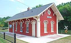
Ann Arbor Railway Station |
|
May 6, 1971
(#71000405) |
126 Wetmore St.
42°36′34″N 83°55′46″W / 42.609444°N 83.929444°W / 42.609444; -83.929444 (Ann Arbor Railway Station) |
Howell |
|
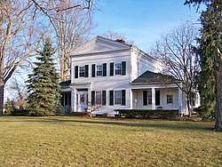
| 2 |
Bingham House |
|
October 18, 1972
(#72000635) |
13270 Silver Lake Rd.
42°29′51″N 83°41′01″W / 42.4974655°N 83.6836954°W / 42.4974655; -83.6836954 (Bingham House) |
Brighton |
|
| 3 |
Jacob Fishbeck Farmstead |
|
April 2, 2003
(#03000178) |
5151 Crooked Lake Rd.
42°33′28″N 83°51′03″W / 42.557778°N 83.850833°W / 42.557778; -83.850833 (Jacob Fishbeck Farmstead) |
Genoa Township |
|
| 4 |
John H. and Martha Durfee Galloway House |
|
November 15, 2006
(#06001030) |
216 Higgins St.
42°36′33″N 83°55′35″W / 42.609167°N 83.926389°W / 42.609167; -83.926389 (John H. and Martha Durfee Galloway House) |
Howell |
|
| 5 |
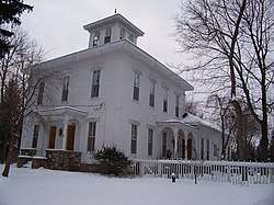
Frank J. Hecox House |
|
July 22, 1994
(#94000745) |
3720 W. Grand River Ave., Howell Township
42°37′43″N 83°59′14″W / 42.628611°N 83.987222°W / 42.628611; -83.987222 (Frank J. Hecox House) |
Howell |
|
| 6 |
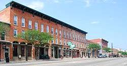
Howell Downtown Historic District |
|
February 27, 1987
(#86003363) |
Roughly bounded by Clinton, Barnard, Sibley, and Chestnut Sts.
42°36′27″N 83°55′49″W / 42.6075°N 83.930278°W / 42.6075; -83.930278 (Howell Downtown Historic District) |
Howell |
|
| 7 |
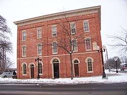
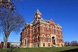
Livingston County Courthouse |
|
August 13, 1976
(#76001031) |
Grand River Ave.
42°36′26″N 83°55′41″W / 42.607222°N 83.928056°W / 42.607222; -83.928056 (Livingston County Courthouse) |
Howell |
|
| 8 |
George Louk Farm |
|
June 15, 1995
(#95000285) |
1885 Tooley Rd., Howell Township
42°37′40″N 83°58′34″W / 42.627778°N 83.976111°W / 42.627778; -83.976111 (George Louk Farm) |
Howell |
|
| 9 |
Alonzo W. Olds House |
|
May 5, 1972
(#72000636) |
10084 Rushton Rd.
42°27′28″N 83°41′49″W / 42.457778°N 83.696944°W / 42.457778; -83.696944 (Alonzo W. Olds House) |
Rushton |
|
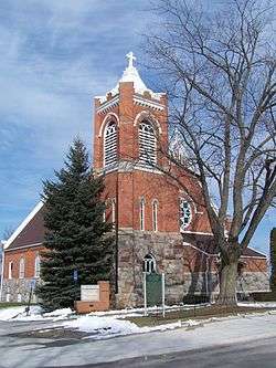
| 10 |
St. Augustine Catholic Church and Cemetery |
|
July 25, 1996
(#96000802) |
6481 Faussett Rd., Deerfield Township
42°42′21″N 83°49′20″W / 42.705833°N 83.822222°W / 42.705833; -83.822222 (St. Augustine Catholic Church and Cemetery) |
Hartland |
|
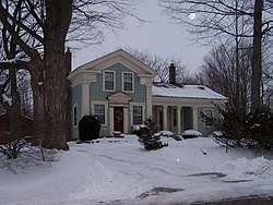
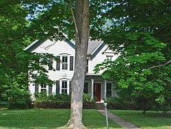
| 11 |
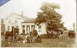
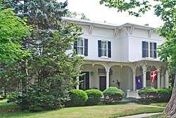
William K. and Nellie (Harper) Sexton House |
|
September 30, 2013
(#13000797) |
205 Mason Road (Marion Township)
42°36′00″N 83°56′08″W / 42.599891°N 83.935675°W / 42.599891; -83.935675 (William K. and Nellie (Harper) Sexton House) |
Howell vicinity |
|
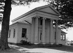
| 12 |
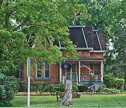
Timothy and Lucretia Jones Warner Homestead |
|
September 8, 2011
(#11000635) |
4001 Pleasant Valley Rd. (Brighton Township)
42°32′45″N 83°42′51″W / 42.54584°N 83.71417°W / 42.54584; -83.71417 (Timothy and Lucretia Jones Warner Homestead) |
Brighton vicinity |
|
| 13 |
Western House |
|
April 17, 1986
(#86000806) |
500 W. Main St.
42°31′46″N 83°47′08″W / 42.529444°N 83.785556°W / 42.529444; -83.785556 (Western House) |
Brighton |
|
| 14 |
August Westphal Farmstead |
|
September 12, 1985
(#85002151) |
6430 Brighton Rd.
42°31′39″N 83°49′27″W / 42.5275°N 83.824167°W / 42.5275; -83.824167 (August Westphal Farmstead) |
Brighton |
|
_Sexton_House_-_facade.jpg)