| [2] |
Name on the Register[3] |
Image |
Date listed[4] |
Location |
City or town |
Description |
|---|
| 1 |
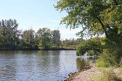
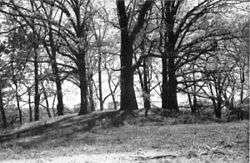
Battle Point Site |
|
August 14, 1973
(#73000956) |
Battle Point, Grand River[5]
43°02′20″N 86°08′40″W / 43.038889°N 86.144444°W / 43.038889; -86.144444 (Battle Point Site) |
Crockery Township |
|
| 2 |
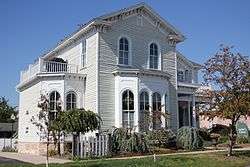
Aloys Bilz House |
|
December 14, 1987
(#87002139) |
107 S. Division St.
43°04′34″N 86°12′03″W / 43.076111°N 86.200833°W / 43.076111; -86.200833 (Aloys Bilz House) |
Spring Lake |
|
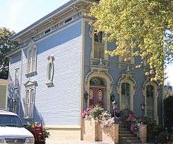
| 3 |
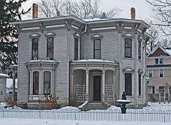
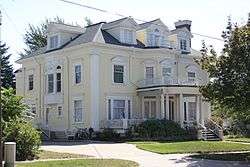
Isaac Cappon House |
|
January 26, 1984
(#84001478) |
228 W. 9th St.
42°47′21″N 86°07′04″W / 42.789167°N 86.117778°W / 42.789167; -86.117778 (Isaac Cappon House) |
Holland |
|
| 4 |
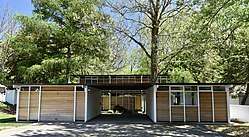
Max and Esther De Pree House |
|
April 17, 2017
(#100000886) |
279 S. Division St.
42°48′24″N 86°00′17″W / 42.806627°N 86.004833°W / 42.806627; -86.004833 (Max and Esther De Pree House) |
Zeeland |
|
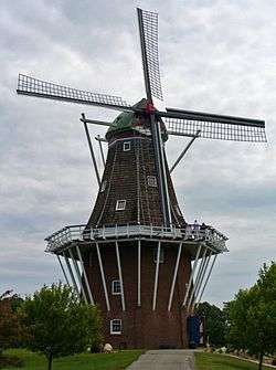
| 4 |
De Zwaan Windmill |
|
April 17, 2018
(#100002333) |
Windmill Island Gardens, 1 Lincoln Ave.
42°47′58″N 86°05′45″W / 42.79947°N 86.0957°W / 42.79947; -86.0957 (De Zwaan Windmill) |
Holland |
|
| 4 |
Edward P. Ferry House |
|
March 19, 1982
(#82002860) |
514 Lafayette St.
43°03′35″N 86°13′38″W / 43.059722°N 86.227222°W / 43.059722; -86.227222 (Edward P. Ferry House) |
Grand Haven |
|
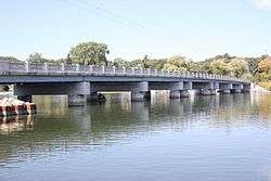
| 5 |
Fruitport Road–Pettys Bayou Bridge |
|
December 17, 1999
(#99001535) |
Fruitport Rd. over Pettys Bayou
43°05′22″N 86°10′31″W / 43.089444°N 86.175278°W / 43.089444; -86.175278 (Fruitport Road–Pettys Bayou Bridge) |
Spring Lake Township |
|
| 6 |
Egbert H. Gold Estate |
|
December 27, 1984
(#84000548) |
1116 Marigold Ln.
42°46′51″N 86°09′21″W / 42.780833°N 86.155833°W / 42.780833; -86.155833 (Egbert H. Gold Estate) |
Holland |
|
| 7 |
Grand Haven Historic District |
|
September 6, 2016
(#16000584) |
Washington Ave, adjacent Sts Harbor Dr. through 600 blks.
43°03′53″N 86°14′01″W / 43.064734°N 86.233632°W / 43.064734; -86.233632 (Grand Haven Historic District) |
Grand Haven |
|
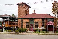
| 8 |
Grand Rapids, Grand Haven and Muskegon Railway Depot |
|
February 6, 1973
(#73002294) |
363 W. Main St.
43°03′51″N 85°56′13″W / 43.064203°N 85.937017°W / 43.064203; -85.937017 (Grand Rapids, Grand Haven and Muskegon Railway Depot) |
Coopersville |
|
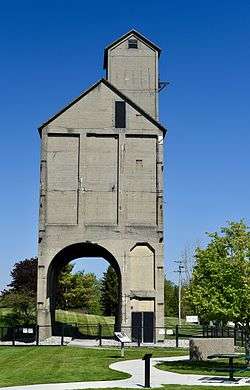
| 9 |
Grand Trunk Western Railroad Grand Haven Coal Tipple |
|
September 6, 2016
(#16000583) |
300 Block of N. Harbor Dr. in Chinook Pier Park
43°04′05″N 86°13′51″W / 43.068080°N 86.230757°W / 43.068080; -86.230757 (Grand Trunk Western Railroad Grand Haven Coal Tipple) |
Grand Haven |
|
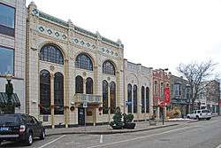
| 10 |
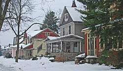
Holland Downtown Historic District |
|
October 4, 1990
(#90001534) |
Roughly Eighth St. from just east of College Ave. to River Ave. and River Ave. from Ninth St. to just north of Eighth St.
42°47′24″N 86°06′26″W / 42.79°N 86.107222°W / 42.79; -86.107222 (Holland Downtown Historic District) |
Holland |
|
| 11 |
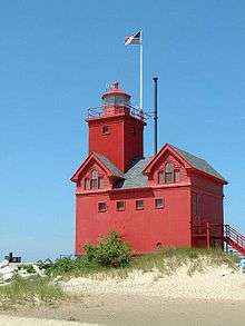
Holland Harbor Lighthouse |
|
July 20, 1978
(#78001509) |
South Pier, Holland Harbor
42°46′22″N 86°12′44″W / 42.772778°N 86.212222°W / 42.772778; -86.212222 (Holland Harbor Lighthouse) |
Holland |
|
| 12 |
Holland Historic District |
|
May 12, 1983
(#83000889) |
11th, 12th, 13th Sts., and Washington, Maple, and Pine Aves.; also roughly bounded by River Ave., Pine Ave., 16th St., 14th St., Columbia Ave., 13th St., Central Ave., and 10th St.
42°47′12″N 86°06′48″W / 42.786667°N 86.113333°W / 42.786667; -86.113333 (Holland Historic District) |
Holland |
Second set of boundaries represents a boundary increase of August 10, 1990 |
| 13 |
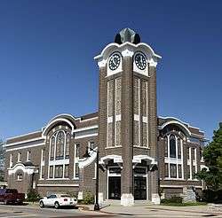
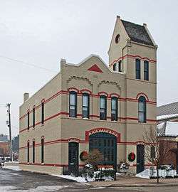
Holland Old City Hall and Fire Station |
|
January 11, 1985
(#85000063) |
108 E. 8th St.
42°47′24″N 86°06′08″W / 42.79°N 86.102222°W / 42.79; -86.102222 (Holland Old City Hall and Fire Station) |
Holland |
|
| 14 |
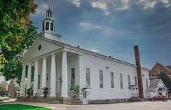
Holland Reformed Protestant Dutch Church |
|
August 23, 1990
(#90001243) |
57 E. 10th St.
42°47′20″N 86°06′17″W / 42.788882°N 86.104833°W / 42.788882; -86.104833 (Holland Reformed Protestant Dutch Church) |
Holland |
Also known as the Pillar Church |
| 15 |
Hudsonville Christian School |
|
March 27, 2008
(#08000224) |
5692 School Ave.
42°52′20″N 85°51′53″W / 42.872222°N 85.864722°W / 42.872222; -85.864722 (Hudsonville Christian School) |
Hudsonville |
|
| 16 |
Thomas and Anna Morrissey House |
|
March 29, 1999
(#99000337) |
190 W. 9th St.
42°47′21″N 86°06′58″W / 42.789167°N 86.116111°W / 42.789167; -86.116111 (Thomas and Anna Morrissey House) |
Holland |
|
| 17 |
Olive Township District No. 1 School |
|
August 14, 1998
(#98001061) |
11611 Stanton St.
42°56′11″N 86°04′21″W / 42.936389°N 86.0725°W / 42.936389; -86.0725 (Olive Township District No. 1 School) |
Olive Township |
|
| 18 |
Ottawa Beach Historic District |
|
April 14, 1995
(#95000451) |
Ottawa Beach Rd.
42°46′34″N 86°12′22″W / 42.776111°N 86.206111°W / 42.776111; -86.206111 (Ottawa Beach Historic District) |
Park Township |
|
| 19 |
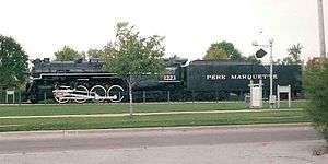
Pere Marquette Railway Locomotive #1223 |
|
December 7, 2000
(#00001490) |
Chinook Pier Park, Jackson Ave.
43°04′04″N 86°13′48″W / 43.067778°N 86.23°W / 43.067778; -86.23 (Pere Marquette Railway Locomotive #1223) |
Grand Haven |
|
| 20 |
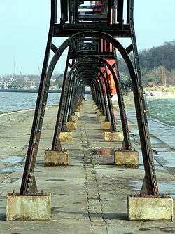
Piers and Revetments at Grand Haven, Michigan |
|
October 23, 1995
(#95001161) |
Mouth of Grand R.
43°03′32″N 86°15′22″W / 43.058889°N 86.256111°W / 43.058889; -86.256111 (Piers and Revetments at Grand Haven, Michigan) |
Grand Haven |
|
| 21 |
Nathaniel and Esther (Savidge) Robbins House |
|
April 16, 2009
(#09000203) |
20 S. 5th Ave.
43°03′45″N 86°13′35″W / 43.062369°N 86.226294°W / 43.062369; -86.226294 (Nathaniel and Esther (Savidge) Robbins House) |
Grand Haven |
|
| 22 |
Spoonville Site |
|
March 30, 1973
(#73002158) |
Crockery Creek and Grand River[5]
43°02′40″N 86°04′30″W / 43.044444°N 86.075°W / 43.044444; -86.075 (Spoonville Site) |
Crockery Township |
|
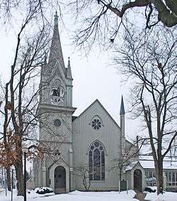
| 23 |
Third Reformed Church of Holland |
|
April 16, 1971
(#71000418) |
110 W. 12th St.
42°47′07″N 86°06′45″W / 42.785278°N 86.1125°W / 42.785278; -86.1125 (Third Reformed Church of Holland) |
Holland |
|
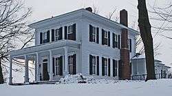
| 24 |
Benjamin Van Raalte House |
|
December 4, 1989
(#89000790) |
1076 Sixteenth St.
42°46′53″N 86°03′43″W / 42.781389°N 86.061944°W / 42.781389; -86.061944 (Benjamin Van Raalte House) |
Holland |
|