National Register of Historic Places listings in Jackson County, Michigan

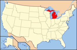
Location of Jackson County in Michigan
This is a list of the National Register of Historic Places listings in Jackson County, Michigan.
This is intended to be a complete list of the properties and districts on the National Register of Historic Places in Jackson County, Michigan, United States. Latitude and longitude coordinates are provided for many National Register properties and districts; these locations may be seen together in a map.[1]
There are 29 properties and districts listed on the National Register in the county.
- This National Park Service list is complete through NPS recent listings posted October 4, 2018.[2]
Current listings
| [3] | Name on the Register[4] | Image | Date listed[5] | Location | City or town | Description |
|---|---|---|---|---|---|---|
| 1 | Clark-Stringham Site | June 19, 1973 (#73002154) |
Address Restricted |
Jackson | ||
| 2 | Collins Manufacturing-Jackson Automobile Company Complex | 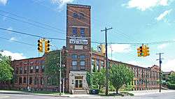 |
July 9, 1993 (#93000622) |
2301 E. Michigan Ave. 42°15′09″N 84°22′32″W / 42.2525°N 84.375556°W |
Jackson | |
| 3 | Concord Village Historic District | 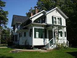 |
July 25, 1996 (#96000810) |
Roughly Hanover St. from Spring to Michigan Sts. and N. Main St. from Railroad to Monroe Sts. 42°10′38″N 84°38′35″W / 42.177222°N 84.643056°W |
Concord | |
| 4 | Denton Road-Sparks Foundation Park Pond Bridge | 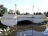 |
January 28, 2000 (#99001676) |
Denton Rd. over Sparks Foundation Park Pond 42°13′38″N 84°25′55″W / 42.227222°N 84.431944°W |
Jackson | |
| 5 | First Congregational Church | 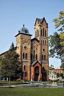 |
July 10, 2017 (#100001294) |
120 N. Jackson St. 42°14′54″N 84°24′32″W / 42.248209°N 84.408783°W |
Jackson | |
| 6 | Ford Motor Company Brooklyn Plant | 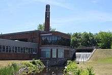 |
January 12, 2017 (#100000532) |
221 Mill St. 42°06′35″N 84°14′43″W / 42.109668°N 84.245258°W |
Brooklyn | |
| 7 | Grass Lake Public School | 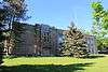 |
May 31, 1984 (#84001693) |
661 E. Michigan Ave. 42°15′06″N 84°12′16″W / 42.251667°N 84.204444°W |
Grass Lake | |
| 8 | Hanover High School Complex | 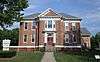 |
December 12, 2012 (#12001030) |
105 Fairview St. 42°06′07″N 84°32′50″W / 42.1020°N 84.5473°W |
Hanover | Currently houses the Lee Conklin Antique Reed Organ & History Museum |
| 9 | Hebrew Cemetery | 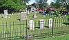 |
June 24, 2009 (#09000474) |
420 N. West Ave. 42°15′09″N 84°25′24″W / 42.25256°N 84.42343°W |
Jackson | |
| 10 | Gordon Hitt Farmstead | 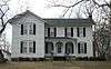 |
July 22, 1994 (#94000743) |
4561 N. Lake Rd. 42°07′27″N 84°20′04″W / 42.1241°N 84.3345°W |
Columbia Township | |
| 11 | Jackson District Library | March 10, 1980 (#80001873) |
244 W. Michigan St. 42°14′53″N 84°24′40″W / 42.248056°N 84.411111°W |
Jackson | ||
| 12 | James M. Jameson Farm | 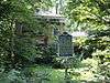 |
July 15, 1980 (#80001875) |
East of Springport at 10220 N. Parma Rd. 42°22′49″N 84°36′02″W / 42.3802°N 84.6006°W |
Springport | |
| 13 | Frederick A., Jr. and Caroline Hewett Kennedy Farm | December 21, 2000 (#00000643) |
8490 Hanover Rd. 42°06′05″N 84°33′56″W / 42.1013°N 84.5656°W |
Hanover Township | ||
| 14 | Kentucky Homestead | 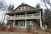 |
July 1, 1994 (#94000663) |
3740 Ocean Beach Rd. 42°07′25″N 84°18′13″W / 42.1235°N 84.3035°W |
Columbia Township | Moved to a county park on the northeast side of Clark Lake. Currently used as the Clark Lake Community Center.[6] |
| 15 | M-50-Sandstone Creek Bridge | 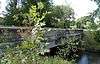 |
January 14, 2000 (#99001674) |
M-50 over Sandstone Creek 42°22′23″N 84°32′42″W / 42.373056°N 84.545°W |
Tompkins Township | |
| 16 | Mann House | |
October 15, 1970 (#70000273) |
205 Hanover St. 42°10′40″N 84°38′36″W / 42.1778°N 84.6432°W |
Concord | |
| 17 | Michigan Central Railroad Jackson Depot | December 12, 2002 (#02001504) |
501 E. Michigan Ave., 42°14′52″N 84°23′58″W / 42.247778°N 84.399444°W |
Jackson | ||
| 18 | Michigan State Prison | 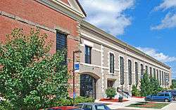 |
August 10, 1979 (#79001156) |
Armory Court and Cooper St. 42°15′27″N 84°24′21″W / 42.2575°N 84.405833°W |
Jackson | |
| 19 | Michigan Theater | 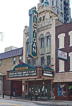 |
May 8, 1980 (#80001874) |
124 N. Mechanic St. 42°14′53″N 84°24′22″W / 42.248056°N 84.406111°W |
Jackson | |
| 20 | Mill Street-South Branch Raisin River Bridge | 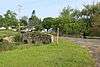 |
January 14, 2000 (#99001675) |
Mill St. over the South Branch of the Raisin River 42°06′36″N 84°14′44″W / 42.11°N 84.245556°W |
Brooklyn | |
| 21 | Otsego Hotel | 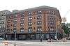 |
April 20, 2015 (#15000158) |
102–106 Francis St. 42°14′50″N 84°24′16″W / 42.247174°N 84.404413°W |
Jackson | |
| 22 | Paddock-Hubbard House |  |
December 9, 1994 (#94001429) |
317 Hanover St. 42°10′40″N 84°38′25″W / 42.1779°N 84.6403°W |
Concord | |
| 23 | Peoples National Bank Building | 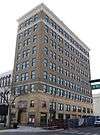 |
December 2, 2014 (#14000977) |
101 E. Michigan Ave. 42°14′50″N 84°24′21″W / 42.2473°N 84.4057°W |
Jackson | |
| 24 | Hugh H. Richard House | 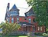 |
December 2, 1993 (#93001352) |
505 Wildwood Ave. 42°14′53″N 84°25′01″W / 42.248056°N 84.416944°W |
Jackson | |
| 25 | Ella Sharp House | 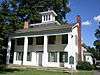 |
August 25, 1972 (#72000622) |
3225 4th St. 42°12′54″N 84°25′04″W / 42.2149°N 84.4179°W |
Jackson | |
| 26 | Siebold Farm/Ruehle (Realy) Farm |  |
March 30, 1973 (#73000952) |
9998 Waterloo-Munith Rd. 42°22′46″N 84°10′48″W / 42.379444°N 84.18°W |
Waterloo Township | |
| 27 | Stone Post Office | 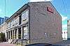 |
March 16, 1972 (#72000623) |
Rear of 125 N. Jackson St. 42°14′51″N 84°24′32″W / 42.2475°N 84.408889°W |
Jackson | |
| 28 | Henry and Aurora (Walker) Vinkle House | July 31, 2017 (#100001391) |
371 W. Michigan Ave. 42°14′56″N 84°13′07″W / 42.248983°N 84.2187°W |
Grass Lake | Also known as the Coe House | |
| 29 | Andrew Wilcox House | 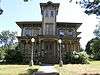 |
December 14, 1987 (#87002138) |
231 E. High St. 42°13′58″N 84°23′54″W / 42.2328°N 84.3984°W |
Jackson |
Former listing
| [3] | Name on the Register | Image | Date listed | Date removed | Location | City or town | Summary |
|---|---|---|---|---|---|---|---|
| 1 | Sidney T. Smith House | 1972 (#72001590) | 1978 | Michigan Ave. 42°15′54″N 84°08′53″W / 42.265°N 84.14805°W |
Grass Lake | Demolished. |
See also
| Wikimedia Commons has media related to National Register of Historic Places in Jackson County, Michigan. |
References
- ↑ The latitude and longitude information provided in this table was derived originally from the National Register Information System, which has been found to be fairly accurate for about 99% of listings. For about 1% of NRIS original coordinates, experience has shown that one or both coordinates are typos or otherwise extremely far off; some corrections may have been made. A more subtle problem causes many locations to be off by up to 150 yards, depending on location in the country: most NRIS coordinates were derived from tracing out latitude and longitudes from USGS topographical quadrant maps created under the North American Datum of 1927, which differs from the current, highly accurate WGS84 GPS system used by most on-line maps. Chicago is about right, but NRIS longitudes in Washington are higher by about 4.5 seconds, and are lower by about 2.0 seconds in Maine. Latitudes differ by about 1.0 second in Florida. Some locations in this table may have been corrected to current GPS standards.
- ↑ "National Register of Historic Places: Weekly List Actions". National Park Service, United States Department of the Interior. Retrieved on October 4, 2018.
- 1 2 Numbers represent an ordering by significant words. Various colorings, defined here, differentiate National Historic Landmarks and historic districts from other NRHP buildings, structures, sites or objects.
- ↑ National Park Service (2008-04-24). "National Register Information System". National Register of Historic Places. National Park Service.
- ↑ The eight-digit number below each date is the number assigned to each location in the National Register Information System database, which can be viewed by clicking the number.
- ↑ "Clake Lake Community Center". Retrieved January 29, 2016.
| Lists by county |
|   |
|---|---|---|
| Other lists |
| |
Municipalities and communities of Jackson County, Michigan, United States | ||
|---|---|---|
| City | | |
| Villages | ||
| Charter townships | ||
| General law townships | ||
| CDPs | ||
| Other unincorporated communities | ||
| Footnotes | ‡This populated place also has portions in an adjacent county or counties | |
This article is issued from
Wikipedia.
The text is licensed under Creative Commons - Attribution - Sharealike.
Additional terms may apply for the media files.