National Register of Historic Places listings in Calhoun County, Michigan
The following is a list of Registered Historic Places in Calhoun County, Michigan.
- This National Park Service list is complete through NPS recent listings posted October 4, 2018.[1]
| [2] | Name on the Register[3] | Image | Date listed[4] | Location | City or town | Description |
|---|---|---|---|---|---|---|
| 1 | 12 Mile Road- Kalamazoo River Bridge | December 22, 1999 (#99001610) |
12 Mile Rd. over Kalamazoo River 42°16′12″N 85°03′41″W / 42.27°N 85.0615°W |
Marshall | ||
| 2 | 23 Mile Road-Kalamazoo River Bridge | 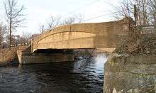 |
December 22, 1999 (#99001611) |
23 Mile Rd. over Kalamazoo River 42°16′06″N 84°50′52″W / 42.268333°N 84.847778°W |
Marengo | |
| 3 | Advent Historic District | 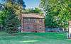 |
June 30, 1994 (#94000623) |
Roughly bounded by N. Washington Ave., Champion St., Hubbard St. and Greenwood Ave. 42°19′49″N 85°11′44″W / 42.330278°N 85.195556°W |
Battle Creek | |
| 4 | Adam C. Arnold Block | March 24, 1983 (#83000839) |
12-14 E. State St. 42°19′09″N 85°10′54″W / 42.319167°N 85.181667°W |
Battle Creek | This building has been demolished.[5] | |
| 5 | Battle Creek City Hall | 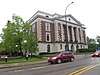 |
April 5, 1984 (#84001377) |
103 E. Michigan Ave. 42°19′00″N 85°10′46″W / 42.316667°N 85.179444°W |
Battle Creek | |
| 6 | Battle Creek Post Office | 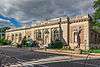 |
August 21, 1972 (#72000597) |
67 E. Michigan St. 42°19′02″N 85°10′48″W / 42.317222°N 85.18°W |
Battle Creek | |
| 7 | Battle Creek Sanitarium | _001.jpg) |
July 30, 1974 (#74000980) |
74 N. Washington St. 42°19′37″N 85°11′16″W / 42.326944°N 85.187778°W |
Battle Creek | Once known as Western Health Reform Institute. Listed as "Federal Center" originally, the name was changed in 2012 with a boundary increase (January 27, 2012) |
| 8 | Boys' Club Building | 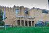 |
May 19, 2004 (#04000457) |
115 West St. 42°19′35″N 85°10′58″W / 42.326525°N 85.1828°W |
Battle Creek | |
| 9 | Harold C. Brooks House | 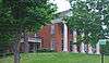 |
July 8, 1970 (#70000266) |
310 N. Kalamazoo Ave. 42°16′28″N 84°57′50″W / 42.274444°N 84.963889°W |
Marshall | Boundary increase (added 1984-04-19): 310 N. Kalamazoo Ave. Also known as the Jabez S. Fitch House. |
| 10 | James and Anne Atmore Bryant Farmstead | June 20, 2002 (#02000667) |
12557 L Dr. N. (Convis Township) 42°20′01″N 85°03′05″W / 42.333611°N 85.051389°W |
Wattles Park | ||
| 11 | Camp Custer Veterans Administration Hospital-United States Veterans Hospital No. 100 | 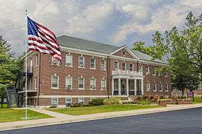 |
May 17, 2012 (#12000282) |
5500 Armstrong Rd. 42°20′36″N 85°17′29″W / 42.343471°N 85.291384°W |
Battle Creek | part of the United States Second Generation Veterans Hospitals Multiple Property Submission |
| 12 | Capitol Hill School | 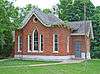 |
March 16, 1972 (#72000598) |
603 Washington St. 42°15′52″N 84°57′10″W / 42.264444°N 84.952778°W |
Marshall | |
| 13 | Central National Tower | .jpg) |
March 20, 2008 (#08000218) |
70 W. Michigan Ave. 42°19′17″N 85°11′03″W / 42.321389°N 85.184167°W |
Battle Creek | |
| 14 | City Hall Historic District | 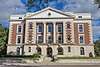 |
April 4, 1996 (#96000366) |
E. Michigan Ave., from Monroe to Jay Sts. 42°19′01″N 85°10′47″W / 42.316944°N 85.179722°W |
Battle Creek | |
| 15 | Cortright-Van Patten Mill | August 31, 1979 (#79001150) |
109 Byron St. 42°08′47″N 84°48′10″W / 42.146389°N 84.802778°W |
Homer | Burned down completely in fire on May 16, 2010. The mill was in operation until the 1970s. In 1974 it was purchased by James L. Miller and converted into a dinner theater. John and Alice Blakemore bought the building in 1996 and opened it as a restaurant. In 2006, new owners Lance and Susan Cuffle opened a bar and restaurant and operated a seasonal haunted house.[6][7] | |
| 16 | Emporium | 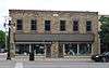 |
August 9, 1979 (#79001151) |
154-156 W. Michigan Ave. 42°16′20″N 84°57′35″W / 42.272222°N 84.959722°W |
Marshall | |
| 17 | Gardner House | 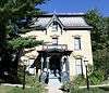 |
May 6, 1971 (#71000383) |
509 S. Superior St. 42°14′30″N 84°45′10″W / 42.2416°N 84.7527°W |
Albion | |
| 18 | Governor's Mansion | 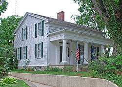 |
January 8, 1975 (#75000939) |
621 S. Marshall Ave. 42°15′54″N 84°57′16″W / 42.265°N 84.954444°W |
Marshall | |
| 19 | Homer Village Historic District | 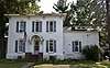 |
July 25, 1996 (#96000805) |
Roughly bounded by Leigh, Burgess, Hamilton, School, and Byron Sts. 42°08′39″N 84°48′27″W / 42.144167°N 84.8075°W |
Homer | |
| 20 | Honolulu House | 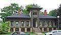 |
July 8, 1970 (#70000267) |
107 N. Kalamazoo St. 42°16′22″N 84°57′52″W / 42.272778°N 84.964444°W |
Marshall | |
| 21 | Joy House | 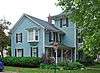 |
April 19, 1972 (#72000599) |
224 N. Kalamazoo Ave. 42°16′25″N 84°57′49″W / 42.273611°N 84.963611°W |
Marshall | |
| 22 | W. K. Kellogg House | 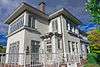 |
April 18, 1985 (#85000838) |
256 W. Van Buren St. 42°19′31″N 85°11′20″W / 42.325278°N 85.188889°W |
Battle Creek | |
| 23 | Isaac Lockwood House |  |
July 22, 1994 (#94000748) |
14011 Verona Rd., Marshall Township 42°17′32″N 85°01′23″W / 42.292222°N 85.023056°W |
Marshall | |
| 24 | Maple Street Historic District | 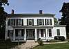 |
July 25, 1996 (#96000806) |
161-342 Capital Ave., NE. 42°19′22″N 85°10′23″W / 42.322778°N 85.173056°W |
Battle Creek | |
| 25 | Marshall Avenue Bridge |  |
September 24, 2001 (#01001021) |
Marshall Ave. over Rice Cr. 42°16′02″N 84°57′15″W / 42.2672373°N 84.9543022°W |
Marshall | |
| 26 | Marshall Michigan Historic Landmark District | July 17, 1991 (#91002053) |
Roughly bounded by Plum St., East Dr., Forest St. and Hanover St. 42°16′27″N 84°57′48″W / 42.274167°N 84.963333°W |
Marshall | ||
| 27 | Masonic Temple Building | 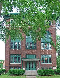 |
September 29, 1988 (#88001836) |
115 E. Green St. 42°16′17″N 84°57′29″W / 42.271389°N 84.958056°W |
Marshall | |
| 28 | Merritt Woods Historic District |  |
June 17, 1994 (#94000622) |
Roughly bounded by Orchard, Emmett and Chestnut Sts. and northernmost parts of Woodmer Dr. and Crest Dr. 42°19′51″N 85°10′19″W / 42.330833°N 85.171944°W |
Battle Creek | |
| 29 | National House | 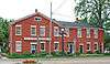 |
January 3, 1978 (#78001493) |
102 S. Parkview 42°16′19″N 84°57′52″W / 42.271944°N 84.964444°W |
Marshall | |
| 30 | Oakhill |  |
December 31, 1974 (#74000981) |
410 N. Eagle St. 42°16′40″N 84°57′21″W / 42.277778°N 84.955833°W |
Marshall | |
| 31 | Penn Central Railway Station | 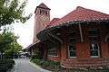 |
April 16, 1971 (#71000384) |
W. Van Buren 42°19′17″N 85°10′54″W / 42.321389°N 85.181667°W |
Battle Creek | |
| 32 | Penniman Castle | 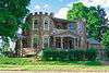 |
May 2, 2001 (#01000457) |
443 Main St. 42°18′21″N 85°10′12″W / 42.305833°N 85.17°W |
Battle Creek | |
| 33 | Pine Creek Potawatomi Reservation | 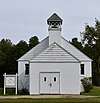 |
March 30, 1973 (#73000946) |
1 mi (1.6 km) west of Athens 42°06′15″N 85°15′32″W / 42.104167°N 85.258889°W |
Athens | |
| 34 | William Prindle Livery Stable | 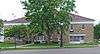 |
August 19, 1982 (#82002829) |
323 W. Michigan Ave. 42°16′17″N 84°57′50″W / 42.271389°N 84.963889°W |
Marshall | |
| 35 | Eugene P. Robertson House | 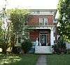 |
February 8, 1988 (#88000028) |
412 S. Clinton St. 42°14′33″N 84°45′17″W / 42.2424°N 84.7548°W |
Albion | |
| 36 | Roosevelt Community House | August 20, 2001 (#01000653) |
117 Evergreen Rd. 42°19′51″N 85°15′49″W / 42.330721°N 85.263584°W |
Springfield | Building was demolished April, 2016 | |
| 37 | Stonehall | 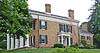 |
June 28, 1972 (#72000600) |
303 N. Kalamazoo St. 42°16′27″N 84°57′52″W / 42.274167°N 84.964444°W |
Marshall | |
| 38 | Stow-Hasbrouck House | 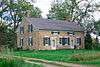 |
December 2, 1993 (#93001361) |
17051 16 Mile Rd., Convis Township 42°20′34″N 84°59′05″W / 42.342778°N 84.984722°W |
Marshall | |
| 39 | Superior Street Commercial Historic District | 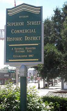 |
August 18, 1997 (#97000626) |
Roughly bounded by the Kalamazoo River, Cass, Elm, Eaton and Vine Sts. 42°14′40″N 84°45′13″W / 42.244444°N 84.753611°W |
Albion | |
| 40 | Van Buren Street Historic District | April 4, 1996 (#96000367) |
Roughly, Van Buren St. from Capital and Cherry Sts. to Calhoun St. and North Ave. 42°19′22″N 85°10′51″W / 42.322778°N 85.180833°W |
Battle Creek | ||
| 41 | Wagner's Block |  |
October 7, 1971 (#71000385) |
143 W. Michigan Ave. 42°16′18″N 84°57′35″W / 42.271667°N 84.959722°W |
Marshall | |
| 42 | Frank and Dorothy Ward House |  |
September 10, 2014 (#14000562) |
257 Lakeshore Dr. 42°17′14″N 85°13′07″W / 42.2871°N 85.2185°W |
Battle Creek | |
| 43 | Wright-Brooks House |  |
March 16, 1972 (#72000601) |
122 N. High St. 42°16′22″N 84°57′12″W / 42.272778°N 84.953333°W |
Marshall |
Former listings
| [2] | Name on the Register | Image | Date listed | Date removed | Location | City or town | Summary |
|---|---|---|---|---|---|---|---|
| 1 | Battle Creek Sanitarium | 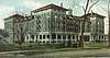 |
unknown (#78001492) | April 18, 1988 | 197 N. Washington Ave. 42°19′37″N 85°11′16″W / 42.326944°N 85.187778°W |
Battle Creek | The former Phelps Sanitarium was purchased by the Battle Creek Sanitarium. |
See also
| Wikimedia Commons has media related to National Register of Historic Places in Calhoun County, Michigan. |
References
- ↑ "National Register of Historic Places: Weekly List Actions". National Park Service, United States Department of the Interior. Retrieved on October 4, 2018.
- 1 2 Numbers represent an ordering by significant words. Various colorings, defined here, differentiate National Historic Landmarks and historic districts from other NRHP buildings, structures, sites or objects.
- ↑ National Park Service (2008-04-24). "National Register Information System". National Register of Historic Places. National Park Service.
- ↑ The eight-digit number below each date is the number assigned to each location in the National Register Information System database, which can be viewed by clicking the number.
- ↑ Arnold, Adam C., Block (Demolished) from the state of Michigan.
- ↑ "Homer Mill fire 'completely devastating' for employees and community; cause of blaze unknown", Aaron Aupperlee, Jackson Citizen Patriot, May 17, 2010
- ↑ "Officers continue to investigate fire at Homer Mill", Danielle Quisenberry, Jackson Citizen Patriot, May 31, 2010
| Lists by county |
|   |
|---|---|---|
| Other lists |
| |
Municipalities and communities of Calhoun County, Michigan, United States | ||
|---|---|---|
| Cities |  | |
| Villages | ||
| Charter townships | ||
| General law townships | ||
| CDPs | ||
| Other unincorporated communities | ||
| Indian reservation | ||
| Footnotes | ‡This populated place also has portions in an adjacent county or counties | |
This article is issued from
Wikipedia.
The text is licensed under Creative Commons - Attribution - Sharealike.
Additional terms may apply for the media files.