National Register of Historic Places listings in Saginaw County, Michigan
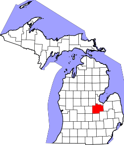
Location of Saginaw County in Michigan
This is a list of the National Register of Historic Places listings in Saginaw County, Michigan.
This is intended to be a complete list of the properties and districts on the National Register of Historic Places in Saginaw County, Michigan, United States. Latitude and longitude coordinates are provided for many National Register properties and districts; these locations may be seen together in a map.[1]
There are 41 properties and districts listed on the National Register in the county.
- This National Park Service list is complete through NPS recent listings posted October 4, 2018.[2]
Current listings
| [3] | Name on the Register[4] | Image | Date listed[5] | Location | City or town | Description |
|---|---|---|---|---|---|---|
| 1 | Bearinger Building | 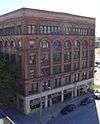 |
July 9, 1982 (#82002861) |
124 N. Franklin St. 43°26′02″N 83°56′14″W / 43.4339°N 83.9372°W |
Saginaw | |
| 2 | Bliss Park | 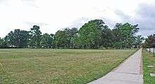 |
December 7, 1995 (#95001424) |
SW of jct. of Houghton St. and N. Michigan Ave. 43°25′42″N 83°57′13″W / 43.4283°N 83.9536°W |
Saginaw | |
| 3 | Abel Brockway House | 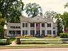 |
July 9, 1982 (#82002862) |
1631 Brockway St. 43°25′03″N 83°59′00″W / 43.4175°N 83.9833°W |
Saginaw | |
| 4 | Bugai Site (20SA215) | October 29, 1982 (#82000543) |
Address Restricted |
Bridgeport | ||
| 5 | Castle Station | 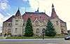 |
January 13, 1972 (#72000652) |
S. Jefferson at Federal St. 43°25′52″N 83°56′08″W / 43.4311°N 83.9355°W |
Saginaw | Now known as Castle Museum of Saginaw County History |
| 6 | Center Road – Tittabawassee River Bridge | November 30, 1999 (#99001458) |
Center Rd. over Tittabawassee River 43°23′37″N 84°00′54″W / 43.3936°N 84.0149°W |
James Township | Demolished in November 2009 and subsequently replaced.[6] | |
| 7 | Central Warehouse | 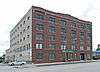 |
July 9, 1982 (#82002864) |
1800 N. Michigan Ave. 43°26′01″N 83°56′56″W / 43.4336°N 83.9489°W |
Saginaw | |
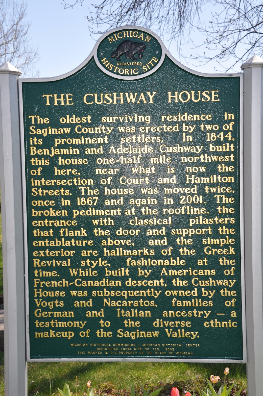
| 8 | Benjamin Cushway House | 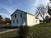 |
July 9, 1982 (#82002865) |
Rust Ave. and Fordney St. 43°24′38″N 83°57′40″W / 43.4106°N 83.9610°W |
Saginaw | At the time of National Register listing, the Cushway House was located at 1404 S. Fayette Street, 43°24′35″N 83°58′32″W / 43.4096°N 83.9755°W. It was relocated to its current location in 2001.[7] |
| 9 | Davis Carriage House | 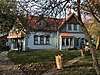 |
July 9, 1982 (#82002863) |
519 N. Fayette St. 43°25′17″N 83°57′40″W / 43.4213°N 83.9611°W |
Saginaw | |
| 10 | East Genesee Historic Business District | 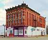 |
July 9, 1982 (#82002866) |
Along E. Genesee Ave., bounded by Federal, Weadock, 2nd and Janes Sts. 43°25′49″N 83°55′58″W / 43.4302°N 83.9327°W |
Saginaw | |
| 11 | East Saginaw Historic Business District | 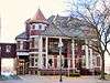 |
July 9, 1982 (#82002867) |
Roughly bounded by Federal, N. Water, N. Washington and N. Franklin Sts. 43°26′00″N 83°56′20″W / 43.4333°N 83.9390°W |
Saginaw | |
| 12 | Flint and Pere Marquette Railroad East Saginaw Depot | 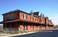 |
November 29, 1996 (#96001378) |
501 Potter St. 43°26′27″N 83°55′59″W / 43.4408°N 83.9330°W |
Saginaw | |
| 13 | Fosters Site (20SA74) | October 29, 1982 (#82000544) |
Address Restricted |
Fosters | ||
| 14 | The Grove | .jpg) |
July 9, 1982 (#82002868) |
S. Washington Ave. 43°24′58″N 83°57′04″W / 43.4161°N 83.9511°W |
Saginaw | |
| 15 | Gugel Bridge | 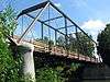 |
March 15, 2000 (#00000217) |
Beyer Rd. at the Cass River 43°19′45″N 83°46′35″W / 43.3291°N 83.7764°W |
Frankenmuth Township | |
| 16 | House at 1514 N. Michigan Street | 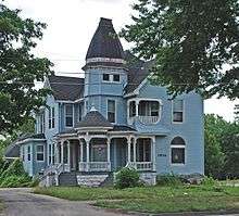 |
July 9, 1982 (#82002869) |
1514 N. Michigan Ave. 43°25′47″N 83°57′02″W / 43.42965°N 83.9505°W |
Saginaw | |
| 17 | Mahoney Site (20SA193) | October 29, 1982 (#82000545) |
Address Restricted |
St. Charles | ||
| 18 | Michigan Bell Building | 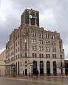 |
July 9, 1982 (#82002870) |
309 S. Washington Ave. 43°25′50″N 83°56′25″W / 43.4306°N 83.9403°W |
Saginaw | |
| 19 | Morseville Bridge | April 5, 1990 (#90000573) |
Burt Rd. at Flint River 43°14′12″N 83°52′06″W / 43.2367°N 83.8682°W |
Taymouth Township | ||
| 20 | Mower Road – Cole Drain Bridge | December 17, 1999 (#99001537) |
Mower Rd. over Cole Drain 43°19′39″N 83°58′07″W / 43.3276°N 83.9686°W |
Spaulding Township | ||
| 21 | North Jefferson Avenue Historic District | July 9, 1982 (#82002871) |
Carroll and Jefferson Aves. 43°26′19″N 83°56′05″W / 43.4386°N 83.9348°W |
Saginaw | ||
| 22 | North Michigan Avenue Historic District | July 9, 1982 (#82002872) |
Roughly bounded by Monroe, Fayette, N. Hamilton and W. Remington Sts. 43°25′21″N 83°57′24″W / 43.4225°N 83.9568°W |
Saginaw | ||
| 23 | Parshallburg Bridge | 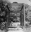 |
October 12, 1994 (#94001168) |
Ditch Rd. over the Shiawassee River, Chesaning Township 43°08′39″N 84°08′06″W / 43.1441°N 84.1351°W |
Oakley | Relocated to Chesaning in 1999, destroyed by flood in 2008.[8] |
| 24 | Passolt House | 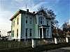 |
October 18, 1972 (#72000653) |
1105 S. Jefferson Ave. 43°25′15″N 83°56′27″W / 43.4209°N 83.9407°W |
Saginaw | |
| 25 | Charles Peters Sr. House | 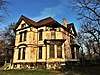 |
July 9, 1982 (#82002873) |
130 N. 6th Ave. 43°25′58″N 83°55′34″W / 43.432766°N 83.925985°W |
Saginaw | |
| 26 | Roethke Houses | 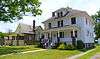 |
June 8, 2001 (#00001485) |
1759 and 1805 Gratiot Ave. 43°24′53″N 83°59′15″W / 43.4148°N 83.98745°W |
Saginaw | |
| 27 | Russell Sackett House | 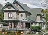 |
July 9, 1982 (#82002874) |
1604 Court St. 43°25′28″N 83°58′23″W / 43.4245°N 83.9731°W |
Saginaw | |
| 28 | Saginaw Armory | 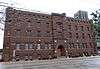 |
March 13, 2002 (#02000161) |
234 S. Water St. 43°25′53″N 83°56′27″W / 43.4313°N 83.9407°W |
Saginaw | |
| 29 | Saginaw Central City Historic Residential District | 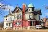 |
February 1, 1979 (#79001168) |
Roughly bounded by Federal Ave., S. Baum St., Park Ave., and Simoneau St. 43°25′37″N 83°56′02″W / 43.426944°N 83.933889°W |
Saginaw | |
| 30 | Saginaw City Historic Business District | July 9, 1982 (#82002876) |
Roughly bounded by Saginaw River, S. Michigan, Cleveland and Van Buren Aves. 43°25′01″N 83°57′49″W / 43.4170°N 83.9635°W |
Saginaw | ||
| 31 | Saginaw County Fairgrounds Main Gate | 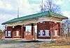 |
December 16, 2014 (#14001045) |
2701 E. Genesee Ave. 43°24′26″N 83°55′02″W / 43.4073°N 83.9171°W |
Saginaw | |
| 32 | Saginaw News Building | December 13, 2016 (#16000838) |
203 S. Washington Ave. 43°25′54″N 83°56′25″W / 43.431756°N 83.940215°W |
Saginaw | ||
| 33 | Schmidt Site | July 27, 1973 (#73000958) |
Address Restricted[9] 43°20′50″N 83°55′10″W / 43.347222°N 83.919444°W |
Bridgeport | Also designated 20SA192 | |
| 34 | Schultz Site (20SA2) Green Point Site (20SA1) | December 8, 1978 (#78002843) |
Near Tittabawassee River and Shiawassee River[10] 43°23′10″N 83°58′10″W / 43.386111°N 83.969444°W |
Spaulding Township | ||
| 35 | South Jefferson Avenue Historic District | 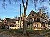 |
July 9, 1982 (#82002877) |
Off M-13 43°25′02″N 83°56′28″W / 43.4172°N 83.9410°W |
Saginaw | |
| 36 | South Michigan Avenue Historic District | July 9, 1982 (#82002878) |
Roughly bounded by Fayette, Lyon, Lee and S. Hamilton Sts. 43°24′44″N 83°58′14″W / 43.4122°N 83.9706°W |
Saginaw | ||
| 37 | St. John's Episcopal Church | 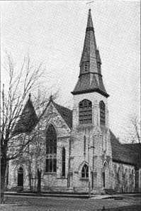 |
July 9, 1982 (#82002879) |
509 Hancock St. 43°25′07″N 83°57′50″W / 43.4185°N 83.9640°W |
Saginaw | |
| 38 | State Street Bridge | 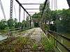 |
November 29, 1995 (#95001391) |
State St. (Fort Rd.) over the Cass River 43°21′29″N 83°52′57″W / 43.3581°N 83.8826°W |
Bridgeport | |
| 39 | Wenzel House | 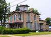 |
July 9, 1982 (#82002880) |
1203 S. Fayette St. 43°24′40″N 83°58′28″W / 43.4112°N 83.9744°W |
Saginaw | |
| 40 | West Side Historic Residential District | July 9, 1982 (#82002881) |
Roughly bounded by Mason, Madison, Harrison and Lyon Sts. 43°25′13″N 83°58′06″W / 43.4203°N 83.9683°W |
Saginaw | ||
| 41 | Ammi and William Wright House | 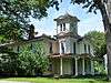 |
July 9, 1982 (#82002882) |
207 Garden Lane 43°24′50″N 83°59′08″W / 43.4139°N 83.9856°W |
Saginaw |
See also
| Wikimedia Commons has media related to National Register of Historic Places in Saginaw County, Michigan. |
References
- ↑ The latitude and longitude information provided in this table was derived originally from the National Register Information System, which has been found to be fairly accurate for about 99% of listings. For about 1% of NRIS original coordinates, experience has shown that one or both coordinates are typos or otherwise extremely far off; some corrections may have been made. A more subtle problem causes many locations to be off by up to 150 yards, depending on location in the country: most NRIS coordinates were derived from tracing out latitude and longitudes from USGS topographical quadrant maps created under the North American Datum of 1927, which differs from the current, highly accurate WGS84 GPS system used by most on-line maps. Chicago is about right, but NRIS longitudes in Washington are higher by about 4.5 seconds, and are lower by about 2.0 seconds in Maine. Latitudes differ by about 1.0 second in Florida. Some locations in this table may have been corrected to current GPS standards.
- ↑ "National Register of Historic Places: Weekly List Actions". National Park Service, United States Department of the Interior. Retrieved on October 4, 2018.
- ↑ Numbers represent an ordering by significant words. Various colorings, defined here, differentiate National Historic Landmarks and historic districts from other NRHP buildings, structures, sites or objects.
- ↑ National Park Service (2008-04-24). "National Register Information System". National Register of Historic Places. National Park Service.
- ↑ The eight-digit number below each date is the number assigned to each location in the National Register Information System database, which can be viewed by clicking the number.
- ↑ "Center Road Bridge", HistoricBridges.org, archived from the original on July 7, 2015, retrieved July 6, 2015 .
- ↑ Michigan Historical Commission, Michigan Historical Center (2005). The Cushway House (Michigan Historical Marker). Saginaw, MI: Michigan Department of Natural Resources. Retrieved July 16, 2015.
- ↑ "Parshallburg Bridge (Ditch Road Bridge)", HistoricBridges.org, archived from the original on July 9, 2015, retrieved July 7, 2015 .
- ↑ The Schmidt Site is listed as "address restricted," but references (Julie Stein (1974), The Schmidt Site: A Geologic Report, Western Michigan University ) show the location. Geo-coordinates are approximate.
- ↑ The Schultz Site and Green Point Sites are listed as "address resticted;" however, references (William A. Lovis; Kathryn C. Egan-Bruhy; Beverley A. Smith; G. William Monaghan (October 2001), "Wetlands and Emergent Horticultural Economies in the Upper Great Lakes: A New Perspective from the Schultz Site", American Antiquity, 66 (4): 615–632 ) show the location near the confluence of the Tittabawassee and Shiawassee. Geocoordinates are approximate.
External links
- Michigan State Historic Preservation Office
- National Park Service, National Register of Historic Places site
Municipalities and communities of Saginaw County, Michigan, United States | ||
|---|---|---|
| Cities | | |
| Villages | ||
| Charter townships | ||
| General law townships | ||
| CDPs | ||
| Other communities |
| |
| Footnotes | ‡This populated place also has portions in an adjacent county or counties | |
| Topics |  | |
|---|---|---|
| Historic places in central city | ||
| Historic places by county in MSA | ||
| Historic places by county in CSA | ||
| Topics | |
|---|---|
| Lists by states |
|
| Lists by insular areas | |
| Lists by associated states | |
| Other areas | |
| |
This article is issued from
Wikipedia.
The text is licensed under Creative Commons - Attribution - Sharealike.
Additional terms may apply for the media files.