| [2] |
Name on the Register[3] |
Image |
Date listed[4] |
Location |
City or town |
Description |
|---|
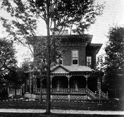
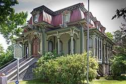
| 1 |
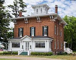
Ezra E. and Florence (Holmes) Beardsley House |
|
April 20, 2015
(#15000157) |
1063 Holmes Rd
41°51′39″N 85°14′08″W / 41.860702°N 85.235505°W / 41.860702; -85.235505 (Ezra E. and Florence (Holmes) Beardsley House) |
Bronson Township |
|
| 2 |
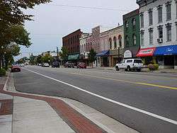
Coldwater Downtown Historic District |
|
July 26, 1990
(#90001124) |
W. Chicago St. from Division to Clay Sts.
41°56′28″N 85°00′14″W / 41.941111°N 85.003889°W / 41.941111; -85.003889 (Coldwater Downtown Historic District) |
Coldwater |
|
| 3 |
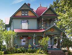
Benedict Doll House |
|
August 20, 1990
(#90001238) |
665 W. Chicago St.
41°56′40″N 85°01′42″W / 41.9445°N 85.028333°W / 41.9445; -85.028333 (Benedict Doll House) |
Coldwater |
|
| 4 |
East Chicago Street Historic District |
|
May 12, 1975
(#75000937) |
Chicago St. from Wright St. to Division St. including parks
41°56′21″N 84°59′40″W / 41.939167°N 84.994444°W / 41.939167; -84.994444 (East Chicago Street Historic District) |
Coldwater |
Boundary increase I (added 1990-08-06): Roughly, Pearl St. between Hudson and Lincoln Sts.
Boundary increase II (added 1990-08-06): Roughly, Church St. from Jefferson to Daugherty Sts., Hull St. from Morse St. to Park Pl., and Park from Church to Hull |
| 5 |
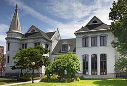
First Presbyterian Church |
|
July 31, 1986
(#86002111) |
52 Marshall St.
41°56′32″N 85°00′01″W / 41.942222°N 85.000278°W / 41.942222; -85.000278 (First Presbyterian Church) |
Coldwater |
|
| 6 |
Abram C. Fisk House |
|
January 12, 1990
(#89002306) |
867 E. Chicago Rd.
41°56′06″N 84°57′52″W / 41.935°N 84.964444°W / 41.935; -84.964444 (Abram C. Fisk House) |
Coldwater |
|
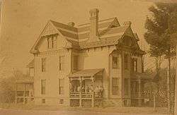
| 7 |
Lanphere-Pratt House |
|
August 20, 1990
(#90001237) |
90 Division St.
41°56′16″N 85°00′08″W / 41.937778°N 85.002222°W / 41.937778; -85.002222 (Lanphere-Pratt House) |
Coldwater |
|
| 8 |
Marshall Street Historic District |
|
August 9, 1990
(#90001123) |
Roughly bounded by Taylor, Hull, N. Hudson, Montgomery and Clay Sts.
41°56′44″N 85°00′07″W / 41.945556°N 85.001944°W / 41.945556; -85.001944 (Marshall Street Historic District) |
Coldwater |
|
| 9 |
South Monroe Street Historic District |
|
July 26, 1990
(#90001121) |
89-175 and 90-146 S. Monroe St. and 17 Park Ave.
41°56′13″N 85°00′14″W / 41.936944°N 85.003889°W / 41.936944; -85.003889 (South Monroe Street Historic District) |
Coldwater |
|
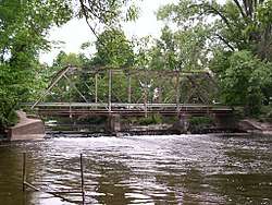
| 10 |
Stancer Road–North Coldwater River Bridge |
|
December 22, 1999
(#99001608) |
Stancer Rd. over N. Coldwater R.
42°01′17″N 85°05′27″W / 42.021389°N 85.090833°W / 42.021389; -85.090833 (Stancer Road–North Coldwater River Bridge) |
Union Township |
|
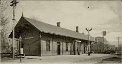
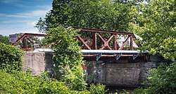
| 11 |
US-12–Coldwater River Bridge |
|
December 22, 1999
(#99001609) |
Old US 12 over Coldwater River
41°56′40″N 85°01′52″W / 41.944444°N 85.031111°W / 41.944444; -85.031111 (US-12–Coldwater River Bridge) |
Coldwater |
|
| 12 |
West Pearl Street Historic District |
|
July 26, 1990
(#90001122) |
155-225 and 160-208 W. Pearl St.
41°56′26″N 85°00′32″W / 41.940556°N 85.008889°W / 41.940556; -85.008889 (West Pearl Street Historic District) |
Coldwater |
|
| 13 |
Wing House |
|
February 24, 1975
(#75000938) |
27 S. Jefferson St.
41°56′20″N 84°59′51″W / 41.938889°N 84.9975°W / 41.938889; -84.9975 (Wing House) |
Coldwater |
|
.jpg)