Mount Ōdaigahara
| Ōdaigahara-san | |
|---|---|
| 大台ケ原 | |
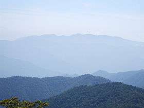 Mount Odaigahara from Mount Hakkyo (2008 September) | |
| Highest point | |
| Elevation | 1,695 m (5,561 ft) |
| Coordinates | 34°07′N 136°02′E / 34.11°N 136.03°E |
| Geography | |
| Location | Mie and Nara, Japan |
Ōdaigahara-san or Ōdaigahara-yama (大台ヶ原山), also Hinode-ga-take or Hide-ga-take (日出ヶ岳) is a mountain in the Daikō Mountain Range and on the border between the prefectures of Mie and Nara, Japan. The mountain is the highest in Mie. In 1980 an area of 36,000 hectares in the region of Mount Ōdaigahara and Mount Ōmine was designated a UNESCO Man and the Biosphere Reserve.[1]
The mountain was also selected by the Tokyo Nichi Nichi Shimbun and Osaka Mainichi Shimbun[2] as one of the 100 Landscapes of Japan in 1927.
See also
References
- ↑ "Biosphere Reserve Information - Mount Odaigahara and Mount Omine". UNESCO. Retrieved 29 April 2011.
- ↑ "日本八景(昭和2年)の選定内容" (PDF). Ministry of the Environment. Retrieved 17 March 2011.
| Wikimedia Commons has media related to Mount Odaigahara. |
| Hokkaidō | |||||||||
|---|---|---|---|---|---|---|---|---|---|
| Tōhoku region Jōshinetsu region |
| ||||||||
| Kantō region | |||||||||
| Chūbu region |
| ||||||||
| Western Japan | |||||||||
| |||||||||
This article is issued from
Wikipedia.
The text is licensed under Creative Commons - Attribution - Sharealike.
Additional terms may apply for the media files.