Katsuragi, Nara
| Katsuragi 葛城市 | |||
|---|---|---|---|
| City | |||
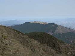 View of Mount Yamato-Katsuragi | |||
| |||
 Location of Katsuragi in Nara Prefecture | |||
 Katsuragi Location in Japan | |||
| Coordinates: 34°29′N 135°44′E / 34.483°N 135.733°ECoordinates: 34°29′N 135°44′E / 34.483°N 135.733°E | |||
| Country | Japan | ||
| Region | Kansai | ||
| Prefecture | Nara Prefecture | ||
| Government | |||
| • Mayor | Yoshihiko Yoshikawa | ||
| Area | |||
| • Total | 33.73 km2 (13.02 sq mi) | ||
| Population (April 1, 2017) | |||
| • Total | 37,235 | ||
| • Density | 1,100/km2 (2,900/sq mi) | ||
| Symbols | |||
| • Tree |
Quercus gilva and camphor laurel | ||
| • Flower |
Peony and chrysanthemum | ||
| • Bird | Japanese bush warbler | ||
| Time zone | UTC+9 (JST) | ||
| City hall address |
166 Kakinomoto, Katsuragi-shi, Nara-ken 639-2195 | ||
| Website |
www | ||

Katsuragi (葛城市 Katsuragi-shi) is a city located in Nara Prefecture, Japan.
As of April 1, 2017, the city has an estimated population of 37,235, and 14,331 households.[1] The population density is 1,100 persons per km2, and the total area is 33.73 km2.
The modern city of Katsuragi was established on October 1, 2004, from the merger of the towns of Shinjō and Taima (both from Kitakatsuragi District).
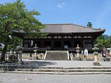
Taima Temple
Neighboring municipalities
Education
Junior high schools
- Shinjo Junior High School
- Hakuhou Junior High School
Elementary schools
- Shinjo Elementary School
- Shinjokita Elementary School
- Oshimi Elementary School
- Iwaki Elementary School
- Taima Elementary School
Transportation
Rail
Road
References
- ↑ "Official website of Katsuragi city" (in Japanese). Japan: Katsuragi City. Retrieved 23 April 2017.
External links
| Wikimedia Commons has media related to Katsuragi, Nara. |
- Katsuragi City official website (in Japanese)

This article is issued from
Wikipedia.
The text is licensed under Creative Commons - Attribution - Sharealike.
Additional terms may apply for the media files.