Batu Pahat District
| Batu Pahat District | ||
|---|---|---|
|
| ||
| Daerah Batu Pahat | ||
| Other transcription(s) | ||
| • Jawi | باتو ڤاهت | |
| • Chinese | 峇株巴辖县 | |
| • Tamil | பத்து பகாட் | |
| ||
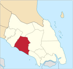 Location of Batu Pahat District in Johor | ||
 Batu Pahat District Location of Batu Pahat District in Malaysia | ||
| Coordinates: 1°55′N 103°0′E / 1.917°N 103.000°ECoordinates: 1°55′N 103°0′E / 1.917°N 103.000°E | ||
| Country |
| |
| State |
| |
| Seat | Batu Pahat (Bandar Penggaram) | |
| Local area government(s) |
Batu Pahat Municipal Council (Batu Pahat West) Yong Peng District Council (Batu Pahat East) | |
| Government | ||
| • District officer | Abdul Han Ramin | |
| Area[1] | ||
| • Total | 1,872.58 km2 (723.01 sq mi) | |
| Population (2010)[2] | ||
| • Total | 398,014 | |
| • Density | 210/km2 (550/sq mi) | |
| Time zone | UTC+8 (MST) | |
| • Summer (DST) | UTC+8 (Not observed) | |
| Postcode | 83xxx | |
| Calling code | +6-07-42 to +6-07-45 | |
| Vehicle registration plates | J | |

The Batu Pahat District is a district in the state of Johor, Malaysia. It lies southeast of Muar, southwest of Kluang, northwest of Pontian, south of Segamat and Tangkak District. The capital of the district is Bandar Penggaram.
Geography
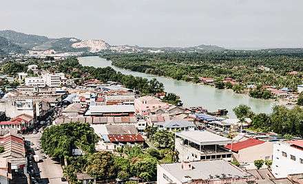
The capital of the district Bandar Penggaram, Batu Pahat is located at 1°51′N 102°56′E / 1.850°N 102.933°E. It is 239 km (150 miles) from Kuala Lumpur. The next nearest town is Muar which is 50 km (30 miles) northwest of Batu Pahat. The town of Kluang is located about 52 km (32 miles) to the northeast. Johor Baru is located about 70 km to 100 km (43 miles to 62 miles) to the southeast of the town.
The district itself borders the districts of Segamat to the north, Kluang to the east, Muar to the west and shares a border in the southeast with the district of Pontian. The coast of the Straits of Melaka lies to the south.
History

The town acquired the name Batu Pahat, which means "chiselled stone", from the quarries near the estuary.[3] There are multiple theories as to the origin of this name. In around 1456, the Siamese army, led by Admiral Awi Di Chu, camped in Batu Pahat before attacking Malacca.[4] Legend has it that the invading Siamese troops were chiselling rocks at a rocky spot in the coastal village of Kampung Minyak Beku, in hope to get fresh water during their retreat from the Melaka troops, led by Tun Perak, the famous Bendahara (Prime Minister) of the Malacca Empire. Another possible explanation for the origin of the name is the fortress ("a famosa") built by the Portuguese after capturing Melaka, which was made from granite rocks taken from the mouth of Sungai Batu Pahat.
Renowned for its salted fish in the past, Batu Pahat was formerly known as Bandar Penggaram, which means "town of salt-makers". In 1893/1894, the present township was founded by Dato' Bentara Luar, Mohamed Salleh bin Perang, acting on the orders of the Sultan of Johor, Sultan Abu Bakar.[5]
Batu Pahat was the location of the headquarters for the 1Bn Fiji Infantry Regiment, serving as part of the Commonwealth forces during the Malayan Emergency, from 1952 to 1956. The 1,600 strong force saw considerable action during the campaign and contributed to the securing of the area during that period.[6]
Today, the ancient well can still be found in Minyak Beku, though little was done to maintain this ancient landmark which gives name to the town. For the town's centennial celebration in the early '90s, a quaint monument depicting a floating hand chiselling a rock was set up in the town square. It became the landmark of the town instantaneously. Currently, the newly refurbished town square is popular with locals on weekend nights and also provides as a venue for many public festive celebrations.
Bandar Penggaram, Batu Pahat is growing rapidly and has now developed to become the second major town in Johor state after Johor Bahru.
Subdivisions and administration
The district is further divided into 14 mukims which are designated with a number (Mukim 1 until 12,17 and 18):[7]
- Lubok (Mukim I) Ditubuhkan 1921
- Bagan (Mukim II) Ditubuhkan 1921
- Peserai (Mukim III) Ditubuhkan 1921
- Simpang Kiri (Mukim IV) Ditubuhkan 1925
- Simpang Kanan (Mukim V) Ditubuhkan 1927
- Linau (Mukim VI) Ditubuhkan 1935
- Tanjung Semberong (Mukim VII) Ditubuhkan 1940
- Sri Gading (Mukim VIII) Ditubuhkan 1942
- Minyak Beku (Mukim IX) Ditubuhkan 1943
- Kampung Bahru (Mukim X) Ditubuhkan 1946
- Sungai Punggor (Mukim XI) Ditubuhkan 1949
- Sungai Kluang (Mukim XII) Ditubuhkan 1952
- Chaah Bahru (Mukim XVII) Ditubuhkan 1957
- Sri Medan (Mukim XVIII) Ditubuhkan 1965
Bandar Penggaram, Batu Pahat is administered by Batu Pahat Municipal Council which was upgraded from the previous District Council (Majlis Daerah Batu Pahat Barat) on 9 June 2001 while Yong Peng is administered by Majlis Daerah Yong Peng or Yong Peng District Council which previous named Majlis Daerah Batu Pahat Timur.
Batu Pahat district has 525 gazetted villages (kampung-kampung pl.) and village-clusters (kampung rangkaian) where smaller villages were annexed to their bigger immediate neighbours for the purpose of administration. The villages are represented by Ketua-Ketua Kampung (village heads), answering to the Penghulu (sub-district chief) administering the sub-district. The sub-district itself however is under the jurisdiction of the Pegawai Daerah (District Officer). The district office of Batu Pahat has five district engineers to oversee all the sub-districts infrastructure.
Growth in small and medium industries such as textiles, garments and electronics helped to boost development, and Batu Pahat was upgraded to town status (Majlis Perbandaran) in 2001, alongside Muar, Kluang and Skudai. As of 2008, the government does not have any plans to upgrade Batu Pahat to a city status (Majlis Bandaraya).
Towns
Demographics
The district of Batu Pahat has a population of about 398,014 local residents.[2] The population growth in 2000 was 1.55%.[8] The most populated mukim is Simpang Kanan with more than 311,862 people and the least populated is Bagan with a population of only 4,692.
The Malays are the majority (51%), while the Chinese (46%) and the Indian (3%).
The major religions are Islam, Buddhism, Christianity, Taoism, Hinduism and Confucianism.
There are two main mosques in Batu Pahat: Masjid Dato' Bentara Luar (located at Jalan Ampuan) and Masjid Sultan Ismail (located at Jalan Kluang). Batu Pahat has over 400 Chinese temples, a reflection of its racial harmony. Some of these temples are beautifully renovated and thus have also become a tourist attraction. Many tourists visit these temples and this has become part of the local economy. A unique Chinese temple located at Bukit Pasir is the Jian Nan Temple. There is also a famous temple located at downtown is the Tian Hou Gong Ma Zor Temple.
Politics
Current election results
.jpg)
.jpg)
Due to electoral division by Election Commission of Malaysia, there are three parliamentary and state constituencies (DUN) dividing Batu Pahat town. There are (P147) Parit Sulong parliamentary seat, (N17) Semerah state seat; (P149) Parliament Sri Gading parliamentary seat, (N21) Parit Yanni state seat and (P150) Batu Pahat parliamentary seat, (N23) Penggaram state seat. (Election Results of the 13th Malaysian General Elections) The last election results listed as below:
'(P150)-Batu Pahat parliament seat'
| Year | Government | Votes | Pct | Opposition | Votes | Pct | Opposition | Votes | Pct | ||||
|---|---|---|---|---|---|---|---|---|---|---|---|---|---|
| 2018 | Haji Mohd Rashid Hasnon (PH) | 45,929 | 56% | Haliza binti Abdullah (BN) | 28,035 | 34% | Dr Mahfodz (PAS) | 8,173 | 10% | ||||
| 2013 | Mohd Idris bin Jusi (PKR) | 38,667 | 51% | Mohd Puad Zarkashi (UMNO) | 36,935 | 49% | |||||||
| 2008 | Mohd Puad Zarkashi (UMNO) | 32,593 | 61% | Muhammad Abdullah (PKR) | 19,625 | 37% | |||||||
| 2004 | Dr Junaidy And Wahab (UMNO) | 38,982 | 78% | Mohamed Hanipa Maidin (PAS) | 9,880 | 20% |
'(N23)-Penggaram state seat'
[Cover most of the area of Batu Pahat town]
| Year | Government | Votes | Pct | Opposition | Votes | Pct | Opposition | Votes | Pct | ||||
|---|---|---|---|---|---|---|---|---|---|---|---|---|---|
| 2018 | Gan Peck Cheng 颜碧贞 (PH) | 26,825 | 64.43% | Kang Beng Kuan 江明光 (BN) | 9,620 | 23.10% | Misran bin Samian (PAS) | 5,185 | 12.47% | ||||
| 2013 | Gan Peck Cheng 颜碧贞 (DAP) | 24,277 | 62% | Dr. King Ban Siang 龚万祥 (MCA) | 14,226 | 37% | |||||||
| 2008 | Datuk Koh Chee Chai 高志财 (MCA) | 12,761 | 47% | Gan Peck Cheng 颜碧贞 (DAP) | 12,186 | 45% | |||||||
| 2004 | Datuk Koh Chee Chai 高志财 (MCA) | 16,845 | 69% | Gan Peck Cheng 颜碧贞 (DAP) | 6,247 | 26% | |||||||
| 1999 | Datuk Seri Dr. Chua Soi Lek 蔡细历 (MCA) | 20,809 | 74% | Gan Peck Cheng 颜碧贞 (DAP) | 7,349 | 26% | |||||||
| 1995 | Datuk Seri Dr. Chua Soi Lek 蔡细历 (MCA) | 20,174 | 77% | Gan Peck Cheng 颜碧贞 (DAP) | 6,137 | 23% |
'(P149)-Sri Gading parliamentary seat'
| Year | Government | Votes | Pct | Opposition | Votes | Pct | Opposition | Votes | Pct | ||||
|---|---|---|---|---|---|---|---|---|---|---|---|---|---|
| 2018 | Dr Shahruddin Salleh (PH) | 21,511 | 49% | AB AZIZ BIN KAPRAWI (BN) | 18,223 | 41% | Haji M Ashari Sidon (PAS) | 4,548 | 10% | ||||
| 2013 | AB AZIZ BIN KAPRAWI (UMNO) | 22,453 | 57% | MOHD KHUZZAN BIN ABU BAKAR (PKR) | 16,692 | 42% | |||||||
| 2008 | Datuk Mohamad Aziz (UMNO) | 19,641 | 68% | Ali Markom (PKR) | 8,767 | 31% | |||||||
| 2004 | Datuk Mohamad Aziz (UMNO) | 21,512 | 80% | Dr Ahmad Faidi Saidi (PKR) | 5,316 | 20% |
'(N21)-Parit Yanni state seat'
[Part of the division in Batu Pahat town e.g.: Taman Maju, Taman Flora Utama, Parit Besar, BP Mall]
| Year | Government | Votes | Pct | Opposition | Votes | Pct | Opposition | Votes | Pct | ||||
|---|---|---|---|---|---|---|---|---|---|---|---|---|---|
| 2018 | AMINOLHUDA BIN HASSAN (PH) | 12,309 | 54% | Soh Lip Yan 蘇立言 (BN) | 7,475 | 33% | Haji Nasir (PAS) | 2,943 | 13% | ||||
| 2013 | AMINOLHUDA BIN HASSAN (PAS) | 11,278 | 52% | TEO YEW CHUAN 张有全 (MCA) | 10,090 | 47% | |||||||
| 2008 | Ng See Tiong 黃世忠 (MCA) | 9,419 | 61% | Hashim Jusoh (PAS) | 5,562 | 37% | |||||||
| 2004 | Ng See Tiong 黃世忠 (MCA) | 10,535 | 76% | Muhamad Yusof Masran (PKR) | 3,259 | 24% |
(P147)-Parit Sulong parliamentary seat
| Year | Government | Votes | Pct | Opposition | Votes | Pct | Opposition | Votes | Pct | ||||
|---|---|---|---|---|---|---|---|---|---|---|---|---|---|
| 2018 | NORAINI BINTI AHMAD (BN) | 24,281 | 49% | Anis Afida (PH) | 18,140 | 37% | Ahmad Rosdi bin Bahari (PAS) | 7,148 | 14% | ||||
| 2013 | NORAINI BINTI AHMAD (UMNO) | 30,258 | 61% | KHAIRUDDIN BIN A RAHIM (PAS) | 18,505 | 38% | |||||||
| 2008 | NORAINI BINTI AHMAD (UMNO) | 26,066 | 66% | Faisal Ali (PAS) | 12,467 | 32% | |||||||
| 2004 | NORAINI BINTI AHMAD (UMNO) | 26,974 | 71% | Suhaizan Kaiat (PAS) | 9,788 | 24% |
(N17)-Semerah state seat
[Part of the division in Batu Pahat town e.g.: Taman Pantai, Jalan Syahbandar, Jalan Rugayah]
| Year | Government | Votes | Pct | Opposition | Votes | Pct | Opposition | Votes | Pct | ||||
|---|---|---|---|---|---|---|---|---|---|---|---|---|---|
| 2018 | Khuzzan Abu Bakar (PH) | 12,619 | 42.85% | MOHD ISMAIL BIN ROSLAN (BN) | 12,521 | 42.51% | Ustaz Wan (PAS) | 4,314 | 14.64% | ||||
| 2013 | MOHD ISMAIL BIN ROSLAN (UMNO) | 14,404 | 55% | MD YSAHRUDIN BIN KUSNI (PKR) | 11,755 | 45% | |||||||
| 2008 | Datuk Ariss Samsudin (UMNO) | 13,156 | 61% | Muhamad Hasmi Hashim (PKR) | 8,082 | 38% | |||||||
| 2004 | Datuk Ariss Samsudin (UMNO) | 15,715 | 74% | Mazlan Aliman (PAS) | 5,046 | 24% |
Economy
The main economy activities in the district are furniture manufacturing, food processing and agritourism.[9] Main industrial towns in the district are Ayer Hitam, Batu Pahat Town, Pekan Sri Wangi, Parit Sulong and Yong Peng. As of 2010, the per capita income was MYR14,122.[10] Local "pasar malam" or night markets are held in residential areas with petty traders setting up stalls and selling a variety of food and daily necessities at bargain prices.
Food
Batu Pahat is a haven for local Malaysian food. The best way to enjoy local Malaysian food, is to savour it with a cup of coffee brewed from locally grown coffee beans. Traditionally, in Malaysia coffee is served in a porcelain cup and saucer, with a small porcelain spoon used to stir your coffee. This has now been replaced in many parts of Malaysia by glasses and plastic spoons, which take away so much of the whole kopi culture. However, in Batu Pahat many eateries, referred to as "Kopitiam", carry on this traditional way of serving coffee. Some of the famous eateries include SJ Corner Kopitiam(角头咖啡店) and Glutton Square(海墘小贩中心). For people whose grown up at Batu Pahat, Hup Seng Ping Pong biscuit from Tongkang Pechah is irreplaceable. It's also a famous biscuit sell to whole Malaysia even whole world- the place have Malaysian.
Batu Pahat is also famous for its nasi bariani. This is a south Indian dish that has long been adopted by local people and now became a signature dish here. The bariani rice is served with either mutton, beef or chicken. Some places also sell vegetarian option. Some famous place for Nasi Bariani is Restoran Bariani Power in Taman Soga near the hospital or Nasi Beriani Md. Shah at the Medan Selera Benteng Peserai.
Batu Pahat is also famous for asam pedas dishes. These are slightly different from the ones served in Malacca. Famous asam pedas outlet is at Jalan Rahmat where there is about 5-6 restaurants all serving asam pedas with different variety in term of opening hours, type of fish and side dishes. Most famous is the first shop Restoran Man Cathays and the next door shop, Asam Pedas Tambak.Warung Mak Siti near Asam Bubuk Estate selling Nasi ayam, Ayam Ungkep and the most top menu soto and now the business take over by Mak Siti sons Fahrul@Abg Fahrul. The hot selling fish is stingray, red snapper, sembilang (a variety of brackish water catfish). One can also have a fish head asam pedas (red snapper). While usually eaten with plain white rice, there is variety of side dishes like bean sprouts, telur masin (salted egg), telur dadar (Malaysian-style omelette), winged bean, or tempeh, all cooked in sambal-like servings. To bring the spiciness into the next level, these food can be eaten with a complimentary sambal belacan.
Shopping
- B.P. Business center (2022)
- Batu Pahat Mall
- SquareOne Mall (Parkson and AEON BiG)
- Summit Parade (Target Supermarket)
- YC Superstore
- Green Point
- Econsave Yong Peng
- Save n' Save
- The Store Batu Pahat
- Nirwana Maju Hypermarket
- Tesco Parit Raja
- Mydin Mall (planning)
Education
In Batu Pahat, there are 24 national secondary schools, 3 independent Chinese secondary schools and a vocational school. Among some of the secondary schools in Batu Pahat are:
- SM Dato' Onn (SMDO)
- SMK Tinggi Batu Pahat 高级中学 (High School Batu Pahat, HSBP)
- Chinese High School
- SMK Convent
- SMK Dato Syed Esa (formerly called SMK Jalan Kolam Air)
- SMK Temenggong Ibrahim (Temenggong Ibrahim Girls' School)
- SMK Munshi Sulaiman
- SMK Dato Bentara Luar
- SMK Datin Onn Jaafar
- SMK Tun Aminah
- SMK Dato' Sulaiman
- SM Teknik
- Maktab Rendah Sains MARA Batu Pahat
- SMK Banang Jaya
- SM Sains Batu Pahat
- SMK Permata Jaya
- SMK Semerah
- SMK Tunku Putra
See also
References
- ↑ "Profil Daerah". ptj.johor.gov.my.
- 1 2 "Population Distribution and Basic Demographic Characteristics, 2010" (PDF). Department of Statistics, Malaysia. Archived from the original (PDF) on 22 May 2014. Retrieved 19 April 2012.
- ↑ Perpustakaan Negara Malaysia Website http://sejarahmalaysia.pnm.my/portalBI/detail.php?ttl_id=8&spesifik_id=82§ion=sm03%5Bpermanent+dead+link%5D
- ↑ "83000 batu pahat, johor » Interesting BP Info".
- ↑ Perpustakaan Negara Malaysia Website "Archived copy". Archived from the original on 13 April 2006. Retrieved 14 April 2006.
- ↑ "YouTube". www.youtube.com.
- ↑ "Kawasan-Kawasan Pentadbiran MPBP - PDF to Flipbook". www.youblisher.com.
- ↑ http://jpbd.johor.gov.my/images/jpbd_DokumenTerbitan/Handbook.pdf
- ↑ "Muafakat ke Arah #Johor Berkemajuan" (PDF). Muafakat Johor (in Malay). Retrieved 17 March 2018.
- ↑ http://jpbd.johor.gov.my/images/jpbd_DokumenTerbitan/Handbook.pdf
External links
| Wikimedia Commons has media related to Batu Pahat. |

- Majlis Perbandaran Batu Pahat
- Ferry Terminal Batu Pahat
- Accommodation
- Batu Pahat Online Portal with maps, news, events and movies
- Batu Pahat Online Directory
- Batu Pahat Online Yellow Pages 峇株吧辖网络黄页
- Batu Pahat Local Web Service
| |
Not Available (★Kangar) | |
| |
| |
☆Kuala Lumpur, Labuan and Putrajaya are Federal Territories (Malaysia) and did not have districts. italics for districts created after 2010 census. | |