Mohawk State Forest
| Mohawk State Forest | |
| Mohawk Mountain State Park | |
| Connecticut State Forest/State Park | |
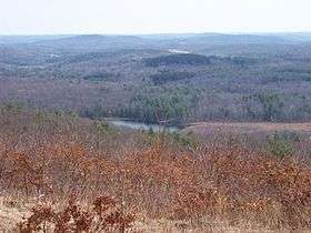 A vista at Mohawk State Forest | |
| Country | |
|---|---|
| State | |
| County | Litchfield |
| Towns | Cornwall, Goshen, Litchfield |
| Elevation | 1,388 ft (423 m) [1] |
| Prominence | 1,680 ft (512 m) Mohawk Mountain[2] |
| Coordinates | 41°49′N 73°17′W / 41.817°N 73.283°WCoordinates: 41°49′N 73°17′W / 41.817°N 73.283°W |
| Area | 4,016 acres (1,625 ha) |
| - State park | 273 acres (110 ha) [3] |
| - State forest | 3,743 acres (1,515 ha) [3] |
| Established | 1921 |
| Management | Connecticut Department of Energy and Environmental Protection |
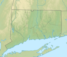 Location in Connecticut | |
| Website: Mohawk State Forest/Mohawk Mountain State Park | |
Mohawk State Forest, also known as Mohawk State Forest/Mohawk Mountain State Park, encompasses over 4,000 acres (1,600 ha) in the towns of Cornwall, Goshen, and Litchfield in the southern Berkshires of Litchfield County, Connecticut. The park and forest are used for hiking, picnicking, and winter sports; they are managed by the Connecticut Department of Energy and Environmental Protection.[4]
History
The forest's name comes indirectly from the Mohawk Indians, who did not live in the area. It is said that local tribes lit fires at the top of the mountain to warn neighboring communities further south of approaching Mohawks. Created with the donation of 2,900 acres (1,200 ha) of land by the White Memorial Trust in 1921, it is the sixth oldest forest in the Connecticut state forest system. The Civilian Conservation Corps was active in the forest during the 1930s.[5]
Points of interest
- Black Spruce Bog
Mohawk State Forest is home to one of the few bogs in Connecticut. Plants such as sheep laurel, leatherleaf, sphagnum moss, sundew, and pitcher plant are found here, with white pine, black spruce, eastern hemlock, and tamarack comprising the overstory. A boardwalk leads visitors into the bog, and there is a separate area for disabled visitors.
- Cunningham Tower
An old, gutted stone tower stands along the blue trail in the northern section of the forest.
- Mohawk Mountain
The top of Mohawk Mountain (elev. 1683 feet) offers sweeping views of the Taconic Mountains and Berkshire Mountains to north and northwest, with peaks well into New York and Massachusetts being visible. On a clear day, Mount Greylock and the eastern Catskills can be seen. The blue-blazed Mattatuck Trail crosses the mountain.
Some peaks visible from the top of the mountain are:
- Bear Mountain (CT)
- Race Mountain (MA)
- Mount Everett (MA)
- Canaan Mountain (CT)
- Cream Hill (CT)
- Wetuwanchu Mountain (CT)
- Mohawk Pond
The southern section of the state forest borders Mohawk Pond, a small kettle pond. It is stocked with brown trout, brook trout, and rainbow trout.
- Red Mountain
Accessible on foot via the blue-blazed Mohawk Trail (formerly the Appalachian Trail), Red Mountain (elev. 1652') occupies the northernmost section of Mohawk State Forest.[6] Due to the shallow bedrock of the peak, the higher elevations of the mountain are home to shrubby oak trees and several scenic views.
Activities and amenities
The area is popular in the winter for cross-country skiing, with skiers and snowboarders using the nearby Mohawk Mountain Ski Area. It is also popular in the fall for leaf-peeping and offers hiking and youth group camping opportunities. It is one of the few forests in Connecticut where hunting is prohibited.[4]
References
- ↑ "Mohawk State Forest". Geographic Names Information System. United States Geological Survey.
- ↑ "Mohawk Mountain". Geographic Names Information System. United States Geological Survey.
- 1 2 "Appendix A: List of State Parks and Forests" (PDF). State Parks and Forests: Funding. Staff Findings and Recommendations. Connecticut General Assembly. January 23, 2014. p. A-2. Retrieved March 20, 2014.
- 1 2 "Mohawk State Forest/Mohawk Mountain State Park". State Parks and Forests. Connecticut Department of Energy and Environmental Protection. July 18, 2016. Retrieved September 28, 2016.
- ↑ "Clues for Mohawk State Forest". Connecticut State Forests Seedling Letterbox Series. Connecticut Department of Energy and Environmental Protection. August 2, 2013. Retrieved September 12, 2017.
- ↑ "Red Mountain". Geographic Names Information System. United States Geological Survey.
External links
- Mohawk State Forest/Mohawk Mountain State Park Connecticut Department of Energy and Environmental Protection
- Mohawk State Forest/Mohawk Mountain State Park Map (north) Connecticut Department of Energy and Environmental Protection
- Mohawk State Forest/Mohawk Mountain State Park Map (south) Connecticut Department of Energy and Environmental Protection
| ||