Housatonic Meadows State Park
| Housatonic Meadows State Park | |
| Connecticut State Park | |
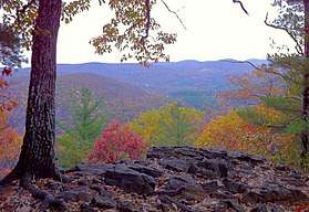 Appalachian Trail's Pine Knob Loop Trail section (in Housatonic Meadows State Park) scenic overlook of the Housatonic River valley in Sharon and Cornwall, CT. | |
| Country | |
|---|---|
| State | |
| County | Litchfield |
| Towns | Cornwall, Sharon |
| Elevation | 518 ft (158 m) [1] |
| Coordinates | 41°50′42″N 73°22′42″W / 41.84500°N 73.37833°WCoordinates: 41°50′42″N 73°22′42″W / 41.84500°N 73.37833°W [1] |
| Area | 452 acres (183 ha) [2] |
| Established | 1927 |
| Management | Connecticut Department of Energy and Environmental Protection |
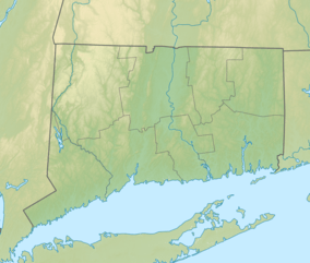 Location in Connecticut | |
| Website: Housatonic Meadows State Park | |
Housatonic Meadows State Park is a public recreation area covering 452 acres (183 ha) along the Housatonic River in the towns of Sharon and Cornwall, Connecticut. The state park offers opportunities for camping, hiking, picnicking, canoeing, and fly-fishing. It is crossed by the Appalachian Trail and is managed by the Connecticut Department of Energy and Environmental Protection.[3]
References
- 1 2 "Housatonic Meadows State Park". Geographic Names Information System. United States Geological Survey.
- ↑ "Appendix A: List of State Parks and Forests" (PDF). State Parks and Forests: Funding. Staff Findings and Recommendations. Connecticut General Assembly. January 23, 2014. p. A-2. Retrieved March 20, 2014.
- ↑ "Housatonic Meadows State Park". State Parks and Forests. Connecticut Department of Energy and Environmental Protection. January 2017. Retrieved October 25, 2017.
External links
- Housatonic Meadows State Park Connecticut Department of Energy and Environmental Protection
- Housatonic Meadows State Park Map Connecticut Department of Energy and Environmental Protection
| Wikimedia Commons has media related to Housatonic Meadows State Park. |
This article is issued from
Wikipedia.
The text is licensed under Creative Commons - Attribution - Sharealike.
Additional terms may apply for the media files.