Lamentation Mountain State Park
| Lamentation Mountain State Park | |
| Connecticut State Park | |
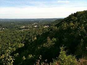 View from high point on Mattabesett ridgeline in Guiffrida Park looking north at Lamentation Mountain (and State Park). | |
| Country | |
|---|---|
| State | |
| County | Hartford |
| Town | Berlin |
| Elevation | 299 ft (91 m) [1] |
| Coordinates | 41°34′44″N 72°45′45″W / 41.57889°N 72.76250°WCoordinates: 41°34′44″N 72°45′45″W / 41.57889°N 72.76250°W [1] |
| Area | 47 acres (19 ha) |
| Established | 1936 |
| Management | Connecticut Department of Energy and Environmental Protection |
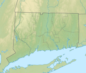 Location in Connecticut | |
| Website: Lamentation Mountain State Park | |
Lamentation Mountain State Park is an undeveloped public recreation area covering 47 acres (19 ha) in the town of Berlin, Connecticut.[2] It entered the roll of state parks in the 1936 edition of the Connecticut Register and Manual.[3] The state park extends for about 0.4 miles (0.64 km) from the Berlin Turnpike up the western flank of Lamentation Mountain to the ridgeline near the Mattabesett Trail. The park offers hiking and scenic vistas.[2]
References
- 1 2 "Lamentation Mountain State Park". Geographic Names Information System. United States Geological Survey.
- 1 2 "Lamentation Mountain State Park". State Parks and Forests. Connecticut Department of Energy and Environmental Protection. Retrieved February 5, 2013.
- ↑ "State Parks". State Register and Manual 1936. State of Connecticut. 1936. p. 129. Retrieved December 6, 2017.
External links
- Lamentation Mountain State Park Connecticut Department of Energy and Environmental Protection
This article is issued from
Wikipedia.
The text is licensed under Creative Commons - Attribution - Sharealike.
Additional terms may apply for the media files.