Minchinabad Tehsil
| Minchinabad Tehsil تحصِيل مِنچِن آباد | ||
|---|---|---|
| Tehsil | ||
| ||
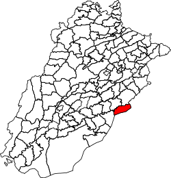 Location of Minchinabad Tehsil in Punjab, Pakistan | ||
| Country |
| |
| Region |
| |
| District | Bahawalnagar | |
| Capital | Minchinabad | |
| Towns | 1 | |
| Union councils | 20 | |
| Government | ||
| • Chairman | Mian Israr Ahmad Paracha | |
| • Vice Chairman | Ameen Khan Bhatti | |
| Area | ||
| • Tehsil | 1,818 km2 (702 sq mi) | |
| Population (2017)[1] | ||
| • Tehsil | 526,428 | |
| • Urban | 72,541 | |
| • Rural | 453,887 | |
| Time zone | UTC+5 (PST) | |
Minchinabad Tehsil (Urdu: تحصِيل مِنچِن آباد), is a tehsil located in Bahawalnagar District, Punjab, Pakistan. The city of Minchinabad is the headquarters of the tehsil which is administratively subdivided into 20 Union Councils.[2]
Geography
Minchinabad Tehsil has an area of 1,818 km2.[3]
Adjacent tehsils
- Depalpur Tehsil, Okara District (north)
- Fazilka Tehsil, Fazilka District, Punjab, India (northeast)
- Sri Ganganagar Tehsil, Sri Ganganagar District, Rajasthan, India (south)
- Karanpur Tehsil, Sri Ganganagar District, Rajasthan, India (southwest)
- Bahawalnagar Tehsil (southwest)
- Pakpattan Tehsil, Pakpattan District (northwest)
Demographics
| Historical population | ||
|---|---|---|
| Year | Pop. | ±% p.a. |
| 1951 | 118,846 | — |
| 1961 | 138,200 | +1.52% |
| 1972 | 185,985 | +2.74% |
| 1981 | 225,838 | +2.18% |
| 1998 | 354,261 | +2.68% |
| 2017 | 526,428 | +2.11% |
| Source: [4][3] | ||
According to the 2017 Census of Pakistan, there are 526,428 people living in Haroonabad Tehsil and 83,173 households.[1] Its population recorded in the 1998 census was 354,261.[3]
References
- 1 2 "DISTRICT AND TEHSIL LEVEL POPULATION SUMMARY WITH REGION BREAKUP: PUNJAB" (PDF). Pakistan Bureau of Statistics. 2018-01-03. Retrieved 2018-04-24.
- ↑ Tehsils & Unions in the District of Bahawalnagar - Government of Pakistan Archived 2012-02-09 at the Wayback Machine.
- 1 2 3 "PLANNING REPORT BAHAWALNAGAR 2008" (PDF). Punjab Municipal Development Fund Company: Punjab Municipal Services Improvement Project (PMSIP). 2008. Retrieved 2018-05-02.
- ↑ "AREA & POPULATION OF ADMINISTRATIVE UNITS BY RURAL/URBAN: 1951-1998 CENSUSES" (PDF). Pakistan Bureau of Statistics. Retrieved 2018-05-14.
External links
This article is issued from
Wikipedia.
The text is licensed under Creative Commons - Attribution - Sharealike.
Additional terms may apply for the media files.