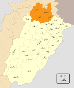
Rawalpindi Division
| Rawalpindi Division | |
|---|---|
 | |
| Area | |
| • Total | 22,255 km2 (8,593 sq mi) |
| Population (2017)[1] | |
| • Total | 10,007,821 |
| • Density | 450/km2 (1,200/sq mi) |
Rawalpindi Division was one of the administrative subdivisions of Punjab Province, Pakistan, forming part of the third tier of government below the federal and provincial levels. Divisions were composed of districts which formed the fourth tier of government, but the local government reform of 2000 abolished administrative divisions and raised the districts to become the new third tier of government[2]
Districts Of Rawalpindi Division
| District | Area (sq mi) | Population (2017) |
|---|---|---|
| Jhelum | 3,587 | 1,222,650 |
| Rawalpindi | 5,286 | 5,405,633 |
| Attock | 6,858 | 1,883,556 |
| Chakwal | 6,524 | 1,495,982 |
| Total | 22,255 | 10,007,821 |
History
British rule
Following the British conquest of the region in 1849, the area around Rawalpindi became a division of the Punjab province of British India, primarily because of the strategic location of the city of Rawalpindi.
The Imperial Gazetteer of India describes the division as follows:
"North-western Division of the Punjab, lying between 31°35' and 34° 1' N. and 70° 37' and 74°29' E. The Commissioner's headquarters are at Rawalpindi and Murree. The total population of the Division increased from 2,520,508 in 1881 to 2,750,713 in 1891, and to 2,799,360 in 1901. Its total area is 15,736 square miles, and the density of the population is 178 persons per square mile, compared with 209 for the Province as a whole"[3]
The division was composed of five districts:
| District | Area (sq mi) | Population (1901) |
|---|---|---|
| Shahpur | 4,840 | 524,259 |
| Jhelum | 2,813 | 501,424 |
| Rawalpindi | 2,010 | 558,699 |
| Attock | 4,022 | 464,430 |
| Total | 13685 | 2,048812 |
After independence
On independence in 1947, the division was one of four divisions of the province of West Punjab but from 1955 to 1970, the divisions was one of twelve (later thirteen) divisions of West Pakistan province under the One Unit policy. On the dissolution of West Pakistan, the division was restored to the new Punjab province, but parts of the division were transferred with parts of Lahore Division to form the new Gujranwala Division.
See also
References
- ↑ "DISTRICT WISE CENSUS RESULTS CENSUS 2017" (PDF). www.pbscensus.gov.pk. Archived from the original (PDF) on 2017-08-29.
- ↑ Divisions/Districts of Pakistan Archived 2006-09-30 at the Wayback Machine.
Note: Although divisions as an administrative structure has been abolished, the election commission of Pakistan still groups districts under the division names - ↑ Rāwalpindi Division - Imperial Gazetteer of India, v. 21, p. 262
This article incorporates text from the Imperial Gazetteer of India, a publication now in the public domain.