Layyah District
| Layyah District ضِلع لیّہ | |
|---|---|
| District | |
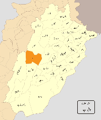 Location of Layyah District (highlighted in orange) within Punjab. | |
| Country |
|
| Province | Punjab |
| Headquarters | Layyah city |
| Government | |
| • District Nazim | N/A |
| Population (2017)[1] | |
| • Total | 1,824,230 |
| Time zone | UTC+5 (PST) |
| Number of Tehsils | 4 |
Layyah District (Urdu: ضِلع ليّہ), (Punjabi: ضلع ليہ),is a district in the Punjab, Pakistan. It is located in the southern part of the province. Layyah City is the district headquarter of Layyah District. Layyah has hot climate, most of the area is desert.
Geography
It lies between 30–45 to 31–24 deg north latitudes and 70–44 to 71–50 deg east longitudes. The area consists of a semi-rectangular block of sandy land between the Indus River and the Chenab River in Sindh Sagar Doab. The total area covered by the district is 6,291 km2 with a width from east to west of 88 km and a length from north to south of 72 km.
History
The town was founded around 1550 by Kamal Khan, a descendant of Ghazi Khan who laid foundation of Dera Ghazi Khan. Around 1610, the town was taken from the Rulers, who held it until 1787. Abdun Nabi Sarai was appointed Governor by Timur Shah Durrani, but three years later it was included in the Governorship of Muhammad Khan Sadozai, who transferred his seat of Government to Mankera. In 1794, Humayun Shah, the rival claimant to the throne of Kabul, was captured near Layyah and brought into the town, where his eyes were put out by order of Zaman Shah. Under the Sikh Government, the town once more became the centre of administration for the neighbouring tract, and after the British occupation in 1849, was for a time the headquarters of a Civil Administrative Division. This administrative status of Layyah was short-lived and the British reduced it to the level of Tehsil headquarters, making it a part of Dera Ismail Khan. In 1901, Layyah was transferred to the new District of Mianwali. Later on, it was made part of the Muzaffargarh District. In 1982, Layyah Tehsil was upgraded to District headquarters comprising three Tehsils: Layyah, Karor and Chaubara. The municipality was created in 1875.[2]
Administrative divisions
The district of Layyah is made up of three tehsils:
Education
According to Pakistan District Education Ranking, a report released by Alif Ailaan, Layyah is ranked at number 38 nationally with an education score of 66.76. The learning score of Layyah is 70.8
The readiness score of Layyah is 65.13 and the school infrastructure of Layyah score is 94.38 , placing it a national rank of 18. The score reflects that most schools in Layyah have all basic facilities e.g. electricity, drinking water and functional toilets.
The issues reported in TaleemDo! App by the residents of Layyah suggest that students of government schools have low confidence as compared to private schools , but the students can’t go to private schools because of high fees. Complaints about quality of teachers and a few basic facilities are also the issues reported in the app.
Floods
Sehar village residents flood-prone Layyah district, had seen their homes repeatedly inundated and they finally took matters into their own hands and rebuilt their homes on raised dirt platforms five to six feet high, shored up with eucalyptus trees planted around the edges.[3][4][5]
Demography
The population, according to the 1998 census was 2 Million. Per capita income during the ten years ending 1902-3 averaged Rs. 9,900, and expenditure Rs. 10,100. In 1903-4, the income was Rs. 10,600, chiefly derived from octroi, and the expenditure was Rs. 10,600.
According to the 2011 district census the Muslim population is by far the largest religious group, constituting 98.7% of the population, followed by Christians, who are barely 1% of the population and are equally spread among the urban and rural area locations.
According to the 1998 census, 62% of the district's population spoke Saraiki as a first language.[6] Punjabi was spoken by 33%, and Urdu – by 3.1%.[7]:32
Gallery
 Railway Station ریلوے اسٹیشن Layyah
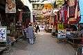 Sadar Bazaar صدر بازار Layyah
 D.H.Q Hospital Layyah, By: Ashiq Hussian Saggu Kot Sultan
References
- ↑ "DISTRICT WISE CENSUS RESULTS CENSUS 2017" (PDF). www.pbscensus.gov.pk.
- ↑ History Layyah.
- ↑ In homegrown innovation, Sehar village rises above flood woes
- ↑ Fight against fury as Layyah’s 382 villages inundated
- ↑ Relief operations under way in flood-hit areas
- ↑ "Mother tongue": defined as the language of communication between parents and children, and recorded of each individual.
- ↑ 1998 District Census report of Layyah. Census publication. 103. Islamabad: Population Census Organization, Statistics Division, Government of Pakistan. 2000.
_Districts.svg.png)