Gujranwala District
| Gujranwala گُوجرانوالا | |
|---|---|
| District | |
| Gujranwala | |
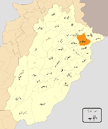 Map of Punjab with Gujranwala District highlighted | |
| Coordinates: 32°10′N 73°50′E / 32.167°N 73.833°ECoordinates: 32°10′N 73°50′E / 32.167°N 73.833°E | |
| Country | Pakistan |
| Province | Punjab |
| Headquarters | Gujranwala |
| Government | |
| • Deputy Commisioner | Tariq Qureshi |
| Area[1] | |
| • Total | 3,622 km2 (1,398 sq mi) |
| Population (2017)[2] | |
| • Total | 5,014,196 |
| • Density | 1,400/km2 (3,600/sq mi) |
| Time zone | UTC+5 (PKT) |
| Number of Tehsils | 5 |
| Languages (1981) | 97.6% Punjabi[3] |
Gujranwala District (Punjabi and Urdu: ضِلع گُوجرانوالا), is a district in Punjab, Pakistan.
History
Gujranwala belonged to the Majha region of ancient Punjab. The village of Asarur has been identified as the location of Taki, an ancient town, visited by the Chinese pilgrim Hiuen Tsiang contains immense ruins of Buddhist origin. After the time of Tsiang little is known about Gujranwala til the Islamic conquests, by this time, however, Taki had fallen into oblivion while Lahore had become the capital of Punjab. The contemporary village of Asarur has been identified as the site of the ancient city. From the beginning of the 7th century Rajput kingdoms dominated Eastern portions of Pakistan and northern India.The district flourished during Mughal rule, from the days of Akbar to those of Aurangzeb, wells were scattered over the whole country, and villages lay thickly dotted about the southern plateau, now a barren waste of grass land and scrub jungle. Their remains may still be found in the wildest and most solitary reaches of the Bar.[4] The Punjab region became predominantly Muslim due to missionary Sufi saints whose dargahs dot the landscape of Punjab region.
Eminabad and Hafizabad were the chief towns (the latter now part of a separate district), while the country was divided into six well-tilled parganas. But before the end of the Islamic period the tract was mysteriously depopulated. The tribes at present occupying the District are all immigrants of recent date, and before their advent the whole region seems for a time to have been almost entirely abandoned. The only plausible conjecture to account for this sudden and disastrous change is that it resulted from the constant wars by which the Punjab was convulsed during the last years of Mughal Imperial rule.[4]
After the decline of the Mughal Empire, the Sikhs invaded and occupied Gujranwala District. Bhangi Misl was the first of many Sikh bands to invade and plunder the Mughal Lahore and other cities in Punjab. Many visitors to Lahore during this era noted that much of the city was in disrepair and many of its Muslim monuments and Mosques were pillaged and desecrated by the Sikhs. The land, palaces and houses of Muslim nobility were confiscated by the Sikhs Sardars. Marbles and precious stones were pillaged from Muslim buildings, including Shalimar Gardens, and homes by the Sikhs to build Golden Temple in Amritsar and the other Sikh holy places. Syed Ahmad Barelvi a Muslim nationalist received desperate pleas of help from the persecuted Muslims of the Punjab region.
The Muslims were prohibited to call Azan and lands belonging to the waqf endowments which provided financial support to Muslim institutions were confiscated by the Sikhs. Syed Ahmad Barelvi in 1821 with many supporters and spent two years organizing popular and material support for his Punjab campaign. He carefully developed a network of people through the length and breadth of India to collect funds and encourage volunteers, traveling widely throughout India attracting a following among pious Muslims. In December 1826 Sayyid Ahmad and his followers clashed with Sikh troops at Okara but with no decisive result. In a major battle near the town of Balakot in 1831, Sayyid Ahmad and Shah Ismail Shaheed with volunteer Muslims were defeated and martyred by the professional Sikh Army.
During the rise of Sikhs, the agricultural lands of Gujranwala were seized from Muslims by the military Sikh adventurers who then sprang up. Charat Singh, the grandfather of Maharaja Ranjit Singh, occupied the village of Gujranwala, then an inconsiderable hamlet, and made it the headquarters of himself and of his son and grandson. Minor Sikh chieftains occupied and settled at Wazirabad, Sheikhupura, and other towns; while in the western portion of the district the Muslim Chatha Jats and Bhatti Rajputs maintained a sturdy independence. In the end, however, he succeeded in bringing all the scattered portions of the District under his own power.[4]
In 1847 the District came under British occupation and two years later, in 1849, it was included in the territory annexed after the second Sikh War. A cantonment was established at Wazirabad, which was abolished in 1855. The District formed a part originally of the extensive District of Wazirabad, which comprised the whole upper portion of the Rechna Doab.[5]
In 1856 the District came under British occupation and two years later, in 1849, it was included in the territory annexed after the second Sikh War. A cantonment was established at Wazirabad, which was abolished in 1855. The District formed a part originally of the extensive District of Wazirabad, which comprised the whole upper portion of the Rechna Doab.[5] Nobles CHAUDRI WARIS ALI TABASSUM In 1852 this unwieldy territory was divided between Gujranwala and Sialkot District. The District, as then constituted, stretched across the entire plateau, from the Chenab to the Ravi; but in 1853 the south-eastern fringe, consisting of 303 villages, was transferred to Lahore District, and three years later a second batch of 324 villages was handed over to the same District. There was no outbreak during the Indian Rebellion of 1857 and the Hindus and Sikh rallied to the side of Government with the greatest enthusiasm while Muslims rallied for the Mughals.[5] According to the 1901 census the District had a population of 890,577 and contained 8 towns and 1,331 villages. Its population according to the 1881 census was 616,892 rising to 690,169 in 1891. The population increased by 29 per cent between 1891 and 1901 - the increase being greatest in the Hafizabad and Khangah Dogran tahsils, owing to the extension of canal-irrigation and the colonisation of the Bar.[5] At the time the district was divided into four tehsils, namely: Gujranwala, Wazirabad, Hafizabad and Khangah Dogran (the headquarters of each being at the place from which it is named).[5] The chief towns during British rule were the municipalities of Gujranwala, the headquarters of the District, Wazirabad, Rasulnagar, Ali Pur Chattha, Eminabad, Qila Didar Singh, and the notified area of Sodhra.[5] During the British era, the district of Gujranwala was part of Lahore Division.[6]
Demography
According to the 1998 census, the population of the district was 3,400,940, of which 51% were urban.[7]:23 The population now stands at 4,308,905.[8]
The most commonly used language of the district is Punjabi, which according to the 1998 census is the first language[9] of 97% of the population, while Urdu accounts for 1.9%.[7]:27
Administration
Gujranwala is in fact a City district. The district is divided into following tehsils:
- Gujranwala City
- Gujranwala Saddar
- Wazirabad Tehsil
- Kamonki
- Naushehra Virkan
Furthermore, there are following towns under these tehsils:
- Khiali Shahpure Town
- Aroop Town
- Nandipur Town
- Qila Didar Singh Town
- Wazirabad Town
- Kamonki Town
- Naushehra Virkan Town
First four towns lie in Gujranwala City and Saddar tehsils while the last three towns are under their respective tehsils, i.e. Tehsil Wazirabad, Kamonki and Naushehra Virkan respectively.
Gujranwala is the district headquarters while Gujranwala, Wazirabad, Kamonki and Naushehra Virkan are tehsil headquarters.
Transport links
Rail
The main Peshawar-Karachi railway line passes through Gujranwala district. The district is linked with Sialkot, Hafizabad and Gujrat districts through railway network.[10]
See also
References
- ↑ "Gujranwala | Punjab Portal". Retrieved 15 December 2016.
- ↑ "DISTRICT WISE CENSUS RESULTS CENSUS 2017" (PDF). www.pbscensus.gov.pk.
- ↑ Stephen P. Cohen (2004). The Idea of Pakistan. Brookings Institution Press. p. 202. ISBN 0815797613.
- 1 2 3 Gujrānwāla District Imperial Gazetteer of India, v. 12, p. 355
- 1 2 3 4 5 6 Gujrānwāla District Imperial Gazetteer of India, v. 12, p. 356
- ↑ Gujrānwāla District - Imperial Gazetteer of India, v. 12, p. 353
- 1 2 1998 District Census report of Gujranwala. Census publication. 37. Islamabad: Population Census Organization, Statistics Division, Government of Pakistan. 1999.
- ↑ Statistics - Official website of Gujranwala Police
- ↑ "Mother tongue": defined as the language of communication between parents and children and recorded of each individual.
- ↑ http://pportal.punjab.gov.pk/portal/portal/media-type/html/group/309/page/default.psml/js_pane/P-10480f054b8-10002?nav=left
External links
| Wikivoyage has a travel guide for Gujranwala. |
Places adjacent to Gujranwala District | ||||||||||
|---|---|---|---|---|---|---|---|---|---|---|
| ||||||||||
_Districts.svg.png)