Southern Tagalog Arterial Road
| |
|---|---|
|
STAR Tollway CALABARZON Expressway | |
 | |
| Route information | |
| Maintained by STAR Infrastructure Development Corporation | |
| Length | 42.0 km (26.1 mi) |
| Component highways | |
| Major junctions | |
| North end |
|
| |
| South end |
|
| Location | |
| Major cities | Tanauan, Lipa, Batangas City |
| Towns | Santo Tomas, Malvar, Ibaan |
| Highway system | |
|
Roads in the Philippines | |
.svg.png)
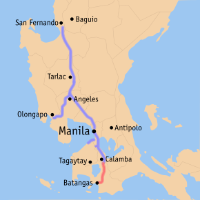
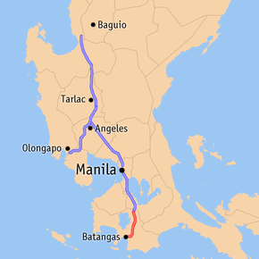
The Southern Tagalog Arterial Road (also known as the STAR Tollway and CALABARZON Expressway) is a two-to-four-lane 42-kilometre (26 mi) expressway in the province of Batangas in the Philippines. It is operated by STAR Infrastructure Development Corporation (STAR – IDC). The expressway is a component of Expressway 2 (E2) of the Philippine expressway network, which also includes the South Luzon Expressway and Skyway.
The expressway starts at the intersection with the Pan-Philippine Highway (also known as the Maharlika Highway) and the South Luzon Expressway in Santo Tomas and runs southward, near Diversion Road, to Batangas City. It passes through Malvar, Tanauan, Lipa and Ibaan.
The expressway was opened on 2001, with its first segment built between Santo Tomas and Lipa. From 2008, it was extended toward Batangas City, and from 2010, the South Luzon Expressway is connected to STAR Tollway, further shortening travel time between Manila and Batangas. The Lipa – Batangas City segment was a two-lane expressway until an addition of a second roadway between Lipa and the Ibaan-Batangas City boundary was opened in 2014. Damage on a bridge in the Ibaan – Batangas City boundary caused by Typhoon Nina (Nock-ten) required the closure of the Ibaan – Batangas City segment for bridge repairs, and diverting traffic to the parallel national roads.
With increasing traffic demand in the Batangas City – Bauan area and the Batangas Bay area, proposals to extend the expressway are laid out to decongest the existing routes through those areas. Two projects are proposed to extend the expressway to barangay Pinamucan, within Batangas City, and to the municipality of Bauan. Like the North Luzon Expressway and SLEX before the construction of Metro Manila Skyway Stage 3, STAR Tollway is separate from the SLEX network despite being connected with SLEX since 2010.
Route description
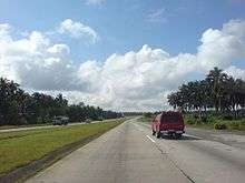
STAR Tollway parallels most of the route of the President Jose P. Laurel Highway (N4), which spurs off from the Maharlika Highway at Santo Tomas towards Lipa and Batangas City, and the Ibaan-Batangas City segment of the Batangas-Quezon Road. The road mostly traverses rural barangays of the cities and municipalities it passes and also overlooks several mountains.
Santo Tomas-Lipa

STAR Tollway starts as the physical extension of South Luzon Expressway past the overpass with the abandoned Philippine National Railways (PNR) branch line to Batangas and an access road for Light Industry and Science Park III at Santo Tomas. Formerly, the toll road ended at Santo Tomas Exit before 2010. The road widens for a short distance at the Santo Tomas toll plaza before narrowing back to two lanes. The road enters Tanauan, with an exit serving the city proper from the west. Past Tanauan Exit, STAR Tollway descends on a scenic curve before ascending on approach to Malvar. Entering Malvar, the road mostly passes rural areas, mostly containing large coconut plantations and small residential areas. Also, within Malvar, Mount Maculot can be seen on the right of the road and Mount Malarayat can be sighted on the left. Afterwards, it enters Lipa, and the road gradually curving before approaching Lipa Exit, which is an access to the city proper, and also to the nearby towns of Mataasnakahoy, Cuenca, and Alitagtag. The exit once served as the tollway's southern terminus until 2007, when STAR Tollway was extended southward towards Batangas City.
Lipa-Batangas City
Past Lipa Exit, STAR Tollway is mostly dual carriageway, until it narrows in approach to Batangas City. This segment was a two-lane expressway from its opening in 2008, until the second roadway opened on 2014. The roadways of this segment is concrete, with the southbound roadway the former two-lane expressway, that has been in bad condition with increased traffic demand.
South of Lipa Exit, the road mostly runs through the rural barangays of Lipa. Then, it curves slightly on approach to San Jose. At approach to Ibaan Exit, the road climbs over the San Jose-Ibaan Road before descending back to ground level. Past Ibaan Exit, STAR Tollway mostly runs a arcing route, traversing several rural barangays of Ibaan and paralleling the Batangas-Quezon Road from Ibaan to Batangas City. The road narrows back to two lanes at Sabang bridge on the Ibaan-Batangas City boundary. The approach to Batangas City from Ibaan was a site of a fatal head-on collision between a jeep and a bus, that killed 7 on January 2011.[1] The road becomes a 3-lane road, with a concrete Jersey barrier dividing the road, ascending in a cutting before following a straight course on rolling terrain up to the STAR Tollway's southern terminus at Balagtas Rotunda. The road widens at the Balagtas toll plaza, narrows back to 3 lanes, and ends at the Balagtas Rotunda, a roundabout with Jose P. Laurel Highway, Batangas Port Diversion Road, and Batangas-Balete Road.
History
In an effort to link the different Southern Tagalog Provinces to the National Capital Region, the government with the cooperation of the Provincial Government of Batangas and with the technical and country developmental assistance of the Government of Japan through the Japan Official Development Assistance, made the STAR Tollway project a reality.
The STAR Tollway I, from Santo Tomas to Lipa, was opened in 2001; STAR Tollway II, from Lipa to the Batangas City Port, opened in 2008. It is fully operational for all motorists. It was opened as part of the Road Development Project of the government, linking the South Luzon Expressway to STAR Tollway onwards to the Batangas Port in Batangas City. The travel time from Manila to Batangas City became 2 hours when Stage 2 opened.
The STAR Tollway Project I and II was funded by Japan Bank for International Cooperation (JBIC) and Japan International Cooperation Agency (JICA) and implemented by the Department of Public Works and Highways – Urban Roads Project Office (DPWH – URPO).
The STAR Tollway is now under the supervision of the Toll Regulatory Board (TRB) and it is being operated by the Star Tollway Corporation.
Redevelopment
Announced by the concessionaire, STAR-Infrastructure Development Corporation (SIDC), on May 16, 2013, the STAR Tollway Upgrading and Rehabilitation Project began on July 2013 as announced by SIDC president Melvin Nazareno. Under the project, the expressway undergone several upgrade and rehabilitation on its roads and facilities in order to cope with the traffic demand of the expressway. The expressway redevelopment included asphalting the Santo Tomas – Lipa segment, upgrading the Lipa – Batangas City segment to a four-lane divided expressway, improvements on the toll collection system, installation of closed circuit television (CCTV) cameras for traffic monitoring, and addition of lighting on some segments.[2] The expansion of the Lipa–Batangas City segment commenced on June 2013, and finished in June 2015 with adding of lights.[3]
Closure and Rehabilitation of Sabang Bridge
Sabang Bridge which connects the town of Ibaan and Batangas City is closed to all traffic due to repair caused by damage of Typhoon Nina (Nock-ten), leaving Ibaan Exit to be the temporary south end of the expressway.[4]
On August 15, 2017, a partial re-opening of Sabang Bridge was conducted for Class 1 vehicles and on August 20, 2017, it was re-opened to all vehicle classes resuming full operations to and from the Batangas Exit.[5]
Future
Pinamucan extension (Pinamucan Access Road)
| STAR Tollway Pinamucan Bypass[6] | |
|---|---|
 | |
| Route information | |
| Length | 10 km (10 mi) |
| Major junctions | |
| From |
|
|
| |
| To | Pinamucan Bypass Road at Pinamucan, Batangas City |
| Highway system | |
|
Roads in the Philippines | |
A 10 km (6.2 mi) extension of STAR Tollway, is proposed by the Sangguniang Panlalawigan of Batangas as two priority projects that will benefit the province as well as Mimaropa. The proposed extension will increase economic growth in the Batangas Bay area and reduce congestion on existing roads in Batangas City. The project will cost ₱576,000,000, and will pass through the barangays of Tinga Itaas, Tinga Labac, San Pedro, Dumantay, Sampaga, Sirang Lupa, and San Isidro, all in Batangas City.[7] The project, dubbed the Pinamucan Bypass Road[6] is expected to be completed before 2021.[8] Right of way construction began on August 21, 2018 under the Batangas 2nd District engineering office. [6]
Exits
The entire route is located in Batangas City. Exits, as well as their names and possible locations, are not yet known, as the project plan is not yet submitted to the Department of Public Works and Highways.
| km | mi | Exit | Name | Destinations | Notes | |
|---|---|---|---|---|---|---|
| 100 | 62 | Tinga | ||||
| Sampaga | ||||||
| 110 | 68 | Pinamucan | ||||
1.000 mi = 1.609 km; 1.000 km = 0.621 mi
| ||||||
Bauan extension
| Batangas City – Bauan Toll Road | |
|---|---|
|
| |
| Route information | |
| Length | 10 km (10 mi) |
| Major junctions | |
| From |
|
| To | Bauan – Mabini Road at Manghinao, Bauan, Batangas |
Another extension to Bauan, called the Batangas City - San Pascual - Bauan Road (originally Batangas City – Bauan Toll Road), is proposed by the Department of Public Works and Highways as an alternative to the existing national road between Batangas City and Bauan. The project is expected to decongest the existing national road, whose traffic demand reached beyond capacity due to roadside establishments, industrial areas, and the Batangas Port, and increase economic development in the Batangas City – Bauan area. The proposed alignment of the toll road will start at the present terminus of STAR Tollway at barangay Balagtas, pass through the northern rural barangays of Batangas City and San Pascual, and end at the national road to Mabini at barangay Manghinao in Bauan. [9] Right of way construction started in February 21, 2018.[6]
Name and origin
On February 9, 2004, Congresswoman Victoria Hernandez Reyes from the Third Congressional District of Batangas of the House of Representatives, authored the House Bill 2753, or also known as the "Act of Renaming the Southern Tagalog Arterial Road (STAR) to Apolinario Mabini Superhighway (AMS)." On May 15, 2007, President Gloria Macapagal Arroyo signed and approved House Bill 2753 to rename the Southern Tagalog Arterial Road to Apolinario Mabini Superhighway, and it was made into a law, now called the Republic Act 9462 (RA 9462).[10]
Technical specifications
- Name: Southern Tagalog Arterial Road
- Concession Holder: STAR Infrastructure Development Corporation
- Operator: STAR Tollway Corporation
- Concession starting date: 2002
- Concession ending date: 2029
- Length: 41.90 km
- Highway exits: 6
- Lanes: four (Sto. Tomas to Ibaan-Batangas City boundary), three (2 lane southbound, 1 lane northbound) (Ibaan-Batangas City boundary to Batangas City)
- Toll plazas: 6
- Rest and service areas: 2
- Minimum height clearance on underpasses: 4.27m (14')
Toll
The whole expressway employs a closed system, where drivers get a card on the entry point and surrender it upon exiting the toll road. Motorists with lost or damaged cards are penalized by paying the toll rate on the exit point with the addition of the rate from the farthest entry point (i.e. Santo Tomas and Batangas City). Toll collection for Santo Tomas Exit, however, are collected at the toll plazas on the road before the exit, the Tanauan toll plaza, for northbound motorists, and the Ayala Greenfield toll plaza on SLEX, for southbound motorists, and vice versa for entering vehicles. There is no electronic collection system used on the expressway.
| Class | Rate |
|---|---|
| Class 1 (Cars, Motorcycles, SUVs, Jeepneys) |
₱1.016/km |
| Class 2 (Buses, Light Trucks) |
₱2.032/km |
| Class 3 (Heavy Trucks) |
₱3.048/km |
Exits
.JPG)
(2018-07-30).jpg)
The entire route is located in Batangas. Exits are numbered by kilometre post, with Rizal Park in Manila designated as kilometre 0.
| City/Municipality | km | mi | Exit | Name | Destinations | Notes | ||
|---|---|---|---|---|---|---|---|---|
| Santo Tomas | 60 | 37 | Santo Tomas | Folded diamond/partial cloverleaf interchange. Access to National Shrine of St. Padre Pio. Road continues north as South Luzon Expressway. | ||||
| Tanauan | 61 | 38 | Tanauan toll plaza (cash payments) | |||||
| 65 | 40 | Tanauan City (Sambat) | Tanauan, Talisay, Laurel, Tagaytay | Diamond interchange. | ||||
| Malvar | 70 | 43 | Malvar (Bulihan) | Malvar | Diamond interchange. | |||
| Lipa | 75 | 47 | Petron KM 75 service area (southbound only) | |||||
| 78 | 48 | Balete (Leviste/Santo Toribio) | Balete | Diamond interchange. | ||||
| 80 | 50 | Petron STAR Tollway northbound service area (northbound only) | ||||||
| 82 | 51 | Lipa City (Tambo) | Lipa, Cuenca, Alitagtag | Folded diamond/partial cloverleaf interchange. Access to De La Salle Lipa and San Sebastian Cathedral | ||||
| Ibaan | 93 | 58 | Ibaan (Malainin) | Ibaan, San Jose | Diamond interchange. | |||
| Ibaan – Batangas City boundary | 99 | 62 | Sabang Bridge. Change to two to three-lane expressway. | |||||
| Batangas City | Pinamucan Bypass Road | Future exit with Pinamucan Bypass Road. Construction not yet started | ||||||
| 101 | 63 | Batangas toll plaza (cash payments) | ||||||
| 102 | 63 | Batangas (Balagtas) | Batangas City, Batangas Port | Roundabout. South end of expressway. Will connect with Batangas City - San Pascual - Bauan Road. | ||||
1.000 mi = 1.609 km; 1.000 km = 0.621 mi
| ||||||||
See also
References
- ↑ Ozaeta, Arnell (January 2, 2011). "7 killed in STAR tollway accident". ABS-CBN News. Retrieved September 14, 2018.
- ↑ Star Tollway Upgrade and Rehab Set, Manila Standard Today, May 16, 2013. Retrieved September 14, 2018.
- ↑ "2.3 Billion Peso Star Tollway expansion starts". The Philippine Star. June 3, 2013. Archived from the original on August 11, 2014. Retrieved June 3, 2013.
- ↑ Bridge repair affects economy in Mimaropa, The Manila Times, January 24, 2017. Retrieevd September 14, 2018.
- ↑ Balagtas Tollgate on STAR Tollway reopened following bridge repair, Autoindustriya, August 15, 2017. Retrieved September 14, 2018.
- 1 2 3 4 "FY 2018 STATUS OF CONTRACTS" (PDF). Department of Public Works and Highways.
- ↑ "2 road networks sa Batangas, isinulong na maging prayoridad ng RDC IV-A". Balikas Online (in Tagalog). August 11, 2016. Archived from the original on March 17, 2017. Retrieved March 16, 2017.
- ↑ City Government of Batangas. "Startoll-Pinamucan Access Road sinisimulan na". www.batangascity.gov.ph (in Tagalog). Retrieved September 14, 2018.
- ↑ "Batangas City-Bauan Toll Road Project". Department Of Public Works and Highways. Retrieved May 11, 2017.
- ↑ BIS Online Query
External links
| Wikimedia Commons has media related to Southern Tagalog Arterial Road. |
| Expressways |
| ||||||
|---|---|---|---|---|---|---|---|
| National highways |
| ||||||
| Operational | |
|---|---|
| Planned |
|
| Under construction | |
See also: Philippine expressway network | |