Malenadu
| Malenadu Malnad | |
|---|---|
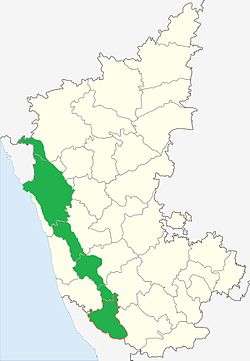 Malenadu region shown in Green | |
| Country |
|
| State |
|
| Region | Malnad |
| Districts | Shivamogga, Sringeri, Uttara Kannada, Koppa, Chikmagalur, Hassan, Kodagu, Dakshina Kannada, Udupi district, Balehonnur. |
| Languages | |
| • Official | Kannada |
| • Regional | Havyaka Kannada, Tulu, Konkani, Kodava, Are Bhashe |
| Time zone | UTC+5:30 (IST) |
Malenadu is a region in the state of Karnataka in India. Malenadu covers the western and eastern slopes of the Western Ghats or Sahyadri mountain range, and is roughly 100 kilometers in width. It is situated between Coastal Karnataka and Bayaluseeme regions of Karnataka.
Climate
The Malenadu region is humid and has an annual rainfall of 1,000–3,800 mm (39–150 in).[1] Sakleshpur in Hassan district, Kottigehara (Attigere) in Mudigere taluk, Hulikallu and Agumbe in Shimoga district and receives the highest rainfall in Karnataka (close to 10,000 mm (390 in)).
AreyMalenadu
The region where we find the features of both Malnad and Bayaluseeme.
1. Shimoga 2. Bhadravathi 3. Shikaripura 4. Sorab 5. Tarikere 6. Hassan 7. Kushalnagar
See also
References
- ↑ "Climate and Rainfall – Karnataka". Retrieved 2006-12-18.
External links
- Elephant attacks spread fear in Malnad region
- Nyctibatrachus major in Malnad, India
- Malenadu Region of Karnataka
This article is issued from
Wikipedia.
The text is licensed under Creative Commons - Attribution - Sharealike.
Additional terms may apply for the media files.