Udupi district
| Udupi district | |
|---|---|
| District | |
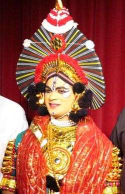 Yakshagana, popular in Udupi dist. | |
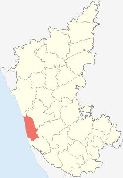 Location of Udupi district in Karnataka, India | |
| Coordinates: 13°21′N 74°45′E / 13.35°N 74.75°ECoordinates: 13°21′N 74°45′E / 13.35°N 74.75°E | |
| Country |
|
| State | Karnataka |
| Region | Tulu Nadu |
| Established | 1997 |
| Headquarters | Udupi |
| Talukas | Udupi, Karkala, Kundapur, Hebri , Byndoor, Brahmavar, Kaup |
| Government | |
| • District Commissioner | Smt. Priyanka Mary Francis |
| Area[1] | |
| • Total | 3,880 km2 (1,500 sq mi) |
| Population [1][2] | |
| • Total | 11,77,361 |
| • Density | 300/km2 (790/sq mi) |
| Languages | |
| • Administrative | Kannada |
| • Regional | Tulu, Konkani, Kundagannada, Beary |
| Time zone | UTC+5:30 (IST) |
| PIN | 576 101 |
| ISO 3166 code | IN-KA-UD |
| Vehicle registration | KA-20 |
| Coastline | 98 kilometres (61 mi) |
| Largest city | Udupi |
| Sex ratio | 1094 ♂/♀ |
| Literacy | 86.24% |
| Lok Sabha constituency | Udupi-Chikmagalur |
| Precipitation | 4,302 millimetres (169.4 in) |
| Website |
udupi |
| Source | |
Udupi district in the Karnataka state of India was created in August 1997. The three northern taluks, Udupi, Kundapur and Karkala, were separated from Dakshina Kannada District to form Udupi district. Udupi district is surrounded by Uttara Kannada district in north, Dakshina Kannada district in southern direction. Shivamogga district borders on north east side and Chikkamagaluru district on east. Arabian sea is on west of Udupi district. Moodbidri was officially declared as new Taluk, seprated from Karkala with effect from January 11, 2018.
The administrative headquarters of Udupi district is Udupi town. Population as per Census 2001 was 1,112,243 of which 18.55% were urban.[3]
Demographics
According to the 2011 census Udupi district has a population of 1,177,908,[4] roughly equal to the nation of Timor-Leste[5] or the US state of Rhode Island.[6] This gives it a ranking of 403rd in India (out of a total of 640).[4] The district has a population density of 304 inhabitants per square kilometre (790/sq mi).[4] Its population growth rate over the decade 2001-2011 was 5.9%.[4] Udupi has a sex ratio of 1093 females for every 1000 males,[4] and a literacy rate of 86.29%.[4]
Climate
Udupi has a tropical climate.[7]
Commerce and industry
A thermal power plant has been set up at Nandikoor in Udupi district by Nagarjuna group for generating electricity. The plant has generated controversies with respect to environmental impact. Suzlon has set up manufacturing facility at Padubidre for making wind mills. Work for setting up of underground petroleum crude reserve at Padur (Padoor) in Udupi district by central government has commenced.[8]
People from Udupi district
- T. M. A. Pai
- K. Shivaram Karanth
- B. R. Shetty
- Santosh Hegde
- R. N. Shetty
- Suniel Shetty
- Rakshith Shetty
- K Jaya Prakash Hegde
See also
References
- 1 2 "Know India - Karnataka". Government of India. Retrieved 6 December 2010.
- ↑ "Census of India 2001: Data from the 2001 Census, including cities, villages and towns (Provisional)". Census Commission of India. Archived from the original on 2004-06-16. Retrieved 2008-11-01.
- ↑ "Census 2001". Archived from the original on 11 January 2010. Retrieved 2006-09-10.
- 1 2 3 4 5 6 "District Census 2011". Census2011.co.in. 2011. Retrieved 2011-09-30.
- ↑ US Directorate of Intelligence. "Country Comparison:Population". Retrieved 2011-10-01.
Timor-Leste 1,177,834 July 2011 est.
- ↑ "2010 Resident Population Data". U. S. Census Bureau. Archived from the original on 19 October 2013. Retrieved 2011-09-30.
Rhode Island 1,052,567
- ↑ India Today: An Encyclopedia of Life in the Republic By Arnold P. Kaminsky, Roger D. Long
- ↑ "Work begins on strategic petroleum reserve in Mangalore". The Hindu. Chennai, India. 2009-05-28.
External links
| Wikimedia Commons has media related to Udupi district. |
| Taluks | |
|---|---|
| Places |
|
| Temples | |
| Udupi cuisines | |
| Society | |
| Beaches | |