Sakleshpur
| Sakleshpur | |
|---|---|
| Hill Station | |
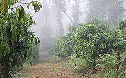 Coffee plantation at Sakleshpur | |
| Nickname(s): Poor Man's Ooty[1][2] | |
 Sakleshpur Location in Karnataka, India | |
| Coordinates: 12°56′35″N 75°46′30″E / 12.943°N 75.775°ECoordinates: 12°56′35″N 75°46′30″E / 12.943°N 75.775°E | |
| Country |
|
| State | Karnataka |
| District | Hassan |
| Region | Malenadu |
| Elevation | 933 m (3,061 ft) |
| Population (2011) | |
| • Total | 23,352[3] |
| Languages | |
| • Official | Kannada |
| Time zone | UTC+5:30 (IST) |
| PIN | 573134 |
| Telephone code | +91–8173 |
| Vehicle registration | KA-46 |
| Sex ratio | 100:80 ♂/♀ |
Sakleshpur or Sakleshapura is a hill station town and headquarters of Sakleshpur taluk in Hassan district in the Indian state of Karnataka.

Economy
The town lies in the Malnad region on the hills of the biodiversity hotspot, the Western Ghats. It has a temperate climate surrounded with lofty green hills full of coffee, cardamom, pepper and areca plantations. These crops which contribute mainly to the economy of the taluk are grown in the surrounding villages and the entire taluk are brought to Sakleshpur city for sale. The town lies on the National Highway 75 (NH 75) which connects the port city of Mangalore (128 km)[4], with the capital city Bangalore (224 km)[5] of Karnataka state. The nearest airport is Mangalore International Airport, situated at a distance of 128 km (80 mi).
Geography
Sakleshpur is located at 12°56′35″N 75°46′30″E / 12.943°N 75.775°E.[6] It has an average elevation of 933 m (3,061 ft) above mean sea level.[7]
Sakleshpur taluk is bounded by Belur taluk to the northeast, Alur taluk to the east, Dakshina Kannada district to the west, Chikkamagaluru district to the northwest and Kodagu district to the southeast and south.
The Western Ghats mountains extend along the western edge of the taluk, separating Sakleshpur from Dakshina Kannada district. The rest of the district lies on the Deccan Plateau. The Hemavathi River, a tributary of the Kaveri, drains the eastern portion of the district, originating in Chikkamagalur district and flowing through Sakleshpur town.
Two rivers originate in Sakleshpur taluk and drain westward through the Ghats. The Kempuhole River originates near Manjarabad Fort and flows westward to join the Netravati River, which empties into the Arabian Sea at Mangalore. The Kumaradhara River, another tributary of the Netravati, drains the southwestern portion of the taluk. These rivers form passes through the Ghats. The Bangalore-Mangalore Highway follows the Kempuhole River, as does the rail line linking Sakleshpur to Mangalore. Bisle Ghat Road follows the Kumaradhara, linking the southwestern portion of the taluk to Kulkunda and Subramanya in Dakshina Kannada.
Demographics
As of 2011 India census,[8] Sakleshpur had a population of 23,352 of which 11,558 are males while 11,794 are females. Sakleshpur has an average literacy rate of 88.47%: male literacy is 92.72%, and female literacy is 84.31%. In Sakleshpur, 11% of the population is under 6 years of age.
Biodiversity
Sakleshpur is located in the Western Ghats, a mountain range that stretches from Kerala to Gujarat. The southern range, which includes Bisle Reserve Forest and the region around Sakleshpur is listed as one of the 18 most diverse spots in the world in terms of flora and fauna. The sub-tropical climate and heavy rains during the wet season create an environment where several unique plant and animal species flourish.
Local flora of Sakleshpur include the reddish-orange pagoda flower (Clerodendrum paniculatum), locally known as raktha pushpa (blood flower).[9]
Manjarabad Fort
The Manjarabad Fort was constructed by Pallada dore its a jail after Tippu Sultan accrued and invigorated this. It is located on the outskirts of Sakleshpur on NH 75. It has a star-shaped fort, with a hillock in the centre and nine corners. The climb to the hillock in the centre is difficult, but offers superb views. There is a hollow entrance in the centre, which is said to the entrance of a tunnel leading to Srirangapattana. There is a mural with the fort's map at the entrance which is in excellent condition. The fort is maintained by the Department of Archeology.[9]
See also
References
- ↑ "Sunday story: Misty Manjarabad – Where Glinting swords clashed for a slice of glory". Deccan Chronicle. 23 July 2017. Retrieved 16 December 2017.
- ↑ "Cardamom, coffee & more". Deccan Herald. 9 September 2014. Retrieved 16 December 2017.
- ↑ "Sakleshpur Population Census 2011". census2011.co.in. Retrieved 20 March 2017.
- ↑ "Distance between Mangalore and Sakleshpur". All Distance Between. Retrieved 17 June 2018.
- ↑ "Distance between Bangalore and Sakleshpur". All Distance Between. Retrieved 17 June 2018.
- ↑ Falling Rain Genomics, Inc – Sakleshpur
- ↑ "Elevation of Sakleshpur".
- ↑ "The Census 2011 is the 15th National census survey conducted by the Census Organization of India". Census Commission of India.
- 1 2 Rao, Bindu Gopal (9 September 2014). "Cardamom, coffee & more". Retrieved 16 January 2015.
| Wikimedia Commons has media related to Sakleshpur. |