Lower Southampton Township, Bucks County, Pennsylvania
| Lower Southampton Township | |
|---|---|
| Township | |
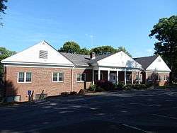 Township Hall | |
 Lower Southampton Township Location in Pennsylvania and the United States  Lower Southampton Township Lower Southampton Township (the US) | |
| Coordinates: 40°09′14″N 74°59′05″W / 40.15389°N 74.98472°WCoordinates: 40°09′14″N 74°59′05″W / 40.15389°N 74.98472°W | |
| Country | United States |
| State | Pennsylvania |
| County | Bucks |
| Area[1] | |
| • Total | 6.72 sq mi (17.40 km2) |
| • Land | 6.67 sq mi (17.29 km2) |
| • Water | 0.04 sq mi (0.11 km2) |
| Elevation | 200 ft (60 m) |
| Population (2010) | |
| • Total | 18,909 |
| • Estimate (2016)[2] | 19,093 |
| • Density | 2,860.37/sq mi (1,104.44/km2) |
| Time zone | UTC-5 (EST) |
| • Summer (DST) | UTC-4 (EDT) |
| Area code(s) | 215 |
| FIPS code | 42-017-45112 |
| Website |
www |
Lower Southampton Township is a township in Bucks County, Pennsylvania, United States. The population was 18,909 at the 2010 census.
Geography
According to the United States Census Bureau, the township has a total area of 6.7 square miles (17.3 km2), all of it land.
Past and present place names include Chinquapin, Churchville, Feasterville, Playwicky, Readingville, and Siles.[3]
Natural features include Edge Hill, Neshaminy Creek, Neshaminy Falls, and Poquessing Creek.[3]
Demographics
As of the 2010 census, the township was 91.9% Non-Hispanic White, 1.8% Black or African American, 0.2% Native American, 2.5% Asian, and 1.1% were two or more races. 2.8% of the population were of Hispanic or Latino ancestry.[4]
As of the census[5] of 2000, there were 19,276 people, 7,152 households, and 5,428 families residing in the township. The population density was 2,886/sq mi (1,114/km2). There were 7,333 housing units at an average density of 1,098/sq mi (423.9/km2). The racial makeup of the township was 96.34% White, 1.07% African American, 0.06% Native American, 1.37% Asian, 0.01% Pacific Islander, 0.42% from other races, and 0.73% from two or more races. Hispanic or Latino of any race were 1.41% of the population.
There were 7,152 households, out of which 32.7% had children under the age of 18 living with them, 63.5% were married couples living together, 8.8% had a female householder with no husband present, and 24.1% were non-families. 19.9% of all households were made up of individuals, and 7.6% had someone living alone who was 65 years of age or older. The average household size was 2.67 and the average family size was 3.10.
In the township the population was spread out, with 22.9% under the age of 18, 7.3% from 18 to 24, 29.3% from 25 to 44, 26.2% from 45 to 64, and 14.3% who were 65 years of age or older. The median age was 40 years. For every 100 females, there were 97.4 males. For every 100 females age 18 and over, there were 95.2 males.
The median income for a household in the township was $57,011, and the median income for a family was $62,209. Males had a median income of $41,902 versus $32,073 for females. The per capita income for the township was $24,367. About 2.7% of families and 3.3% of the population were below the poverty line, including 3.6% of those under age 18 and 5.2% of those age 65 or over.
| Historical population | |||
|---|---|---|---|
| Census | Pop. | %± | |
| 1930 | 1,077 | — | |
| 1940 | 1,843 | 71.1% | |
| 1950 | 3,562 | 93.3% | |
| 1960 | 12,619 | 254.3% | |
| 1970 | 17,578 | 39.3% | |
| 1980 | 18,305 | 4.1% | |
| 1990 | 19,860 | 8.5% | |
| 2000 | 19,276 | −2.9% | |
| 2010 | 18,909 | −1.9% | |
| Est. 2016 | 19,093 | [2] | 1.0% |
| [6] | |||
Climate
During the summer months, frequent episodes of high humidity occur. Occasionally, heat index values exceed 100°F (38°C). On average, the wettest month of the year is July which corresponds with the annual peak for thunderstorm activity. During the winter months, wind chill values occasionally fall below 0°F (-18°C). On average, the snowiest month of the year is February which corresponds with the annual peak for nor'easter activity.
| Climate data for Lower Southampton Township, Pennsylvania (1981 – 2010 averages). Elevation 200 ft (61 m). | |||||||||||||
|---|---|---|---|---|---|---|---|---|---|---|---|---|---|
| Month | Jan | Feb | Mar | Apr | May | Jun | Jul | Aug | Sep | Oct | Nov | Dec | Year |
| Average high °F (°C) | 39.9 (4.4) |
43.1 (6.2) |
51.3 (10.7) |
63.1 (17.3) |
72.6 (22.6) |
81.8 (27.7) |
86.0 (30) |
84.4 (29.1) |
77.5 (25.3) |
66.2 (19) |
55.4 (13) |
44.2 (6.8) |
63.8 (17.7) |
| Average low °F (°C) | 23.8 (−4.6) |
25.7 (−3.5) |
32.3 (0.2) |
41.9 (5.5) |
51.2 (10.7) |
61.0 (16.1) |
66.1 (18.9) |
64.7 (18.2) |
57.3 (14.1) |
45.5 (7.5) |
37.0 (2.8) |
28.5 (−1.9) |
44.6 (7) |
| Average precipitation inches (mm) | 3.55 (90.2) |
2.73 (69.3) |
4.14 (105.2) |
3.98 (101.1) |
4.33 (110) |
4.34 (110.2) |
5.20 (132.1) |
4.41 (112) |
4.39 (111.5) |
3.75 (95.3) |
3.62 (91.9) |
3.96 (100.6) |
48.4 (1,229.4) |
| Average snowfall inches (cm) | 8.0 (20.3) |
8.9 (22.6) |
3.8 (9.7) |
0.7 (1.8) |
0.0 (0) |
0.0 (0) |
0.0 (0) |
0.0 (0) |
0.0 (0) |
0.0 (0) |
0.5 (1.3) |
4.0 (10.2) |
25.9 (65.9) |
| Source: PRISM[7] | |||||||||||||
Transportation
The Pennsylvania Turnpike (Interstate 276) passes east-west through Lower Southampton Township, but the nearest interchange is to the east in neighboring Bensalem Township. Numbered routes serving the township include Pennsylvania Route 132, which runs northwest-southeast through the township along Street Road; Pennsylvania Route 532, which runs north-south through the township along Bustleton Pike and Buck Road; and Pennsylvania Route 213, which begins at PA 532 in the township and heads northeast along Bridgetown Pike. Other important roads include County Line Road, which begins at PA 532 and heads northwest along the border separating Lower Southampton Township from Philadelphia and Montgomery County; Bustleton Pike, which follows PA 532 in the southern part of the township before splitting to the northwest; Philmont Avenue, which begins at PA 132 and heads southwest through the southern part of the township; Brownsville Road, which begins near PA 132 and heads northeast through the eastern part of the township; and Bristol Road, which runs northwest-southeast through the northern portion of the township, with a gap between PA 532 and PA 213.[8]
SEPTA provides public transportation in Lower Southampton Township. SEPTA Regional Rail's West Trenton Line passes east-west through the southern portion of the township; the nearest stations are Somerton station in the Somerton neighborhood of Northeast Philadelphia and Trevose station and Neshaminy Falls station in Bensalem Township. SEPTA City Bus Route 58 serves the township along its route between the Neshaminy Mall and the Frankford Transportation Center in Northeast Philadelphia.[9] Norfolk Southern Railway's Morrisville Line freight railroad line passes east-west through the northern part of Lower Southampton Township.[8][10]
References
- ↑ "2016 U.S. Gazetteer Files". United States Census Bureau. Retrieved Aug 13, 2017.
- 1 2 "Population and Housing Unit Estimates". Retrieved June 9, 2017.
- 1 2 MacReynolds, George, Place Names in Bucks County, Pennsylvania, Doylestown, Bucks County Historical Society, Doylestown, PA, 1942, P1.
- ↑ "Census 2010: Pennsylvania - USATODAY.com". USA TODAY News. Retrieved 2016-05-15.
- ↑ "American FactFinder". United States Census Bureau. Retrieved 2008-01-31.
- ↑ http://www.dvrpc.org/data/databull/rdb/db82/appedixa.xls
- ↑ "Data Explorer: Time Series Values for Individual Locations". PRISM. Oregon State University. Retrieved May 24, 2017.
- 1 2 Bucks County, Pennsylvania Highway Map (PDF) (Map). PennDOT. 2015. Retrieved January 10, 2016.
- ↑ SEPTA Official Transit & Street Map Suburban (PDF) (Map). SEPTA. Retrieved May 2, 2016.
- ↑ Norfolk Southern Harrisburg Region Timetable 1, August 4, 2008
External links
| Wikimedia Commons has media related to Lower Southampton Township, Bucks County, Pennsylvania. |
| Preceded by Lower Moreland Township Montgomery County |
Bordering communities of Philadelphia |
Succeeded by Bensalem |
