Livingston Range
| Livingston Range | |
|---|---|
 Kintla Peak | |
| Highest point | |
| Peak | Kintla Peak |
| Elevation | 10,101 ft (3,079 m) |
| Coordinates | 48°56′38″N 114°10′16″W / 48.94389°N 114.17111°WCoordinates: 48°56′38″N 114°10′16″W / 48.94389°N 114.17111°W |
| Dimensions | |
| Length | 36 mi (58 km) |
| Width | 28 mi (45 km) |
| Geography | |
| Countries | United States and Canada |
| States/Provinces | Montana and British Columbia |
| Parent range | Rocky Mountains |
| Geology | |
| Orogeny | Lewis Overthrust |
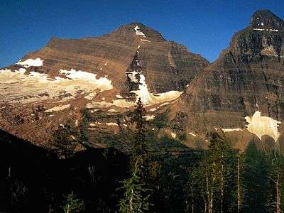
The Livingston Range is a mountain range located primarily in Glacier National Park in the U.S. state of Montana, and in the extreme southeastern section of the Canadian province of British Columbia. The range is 36 miles (58 km) long and 28 miles (45 km) wide. Over 15 summits exceed 9,000 ft (2,700 m) above sea level, and the highest point is Kintla Peak at 10,101 feet (3,079 m). (While these elevations are not particularly high for North American mountains, they are high compared to the roughly 4,000 foot (1,200 m) elevation of the nearby valleys, making for particularly dramatic peaks.)
The Livingston Range was initially uplifted beginning 170 million years ago when the Lewis Overthrust fault pushed an enormous slap of precambrian rocks 3 mi (4.8 km) thick, 50 miles (80 km) wide and 160 miles (260 km) long over newer rocks of the cretaceous period.
See also
Notes
External links
- Glacier National Park. "Mountains". Nature and Science. Archived from the original on 2006-06-18. Retrieved 2006-05-08.
- "Livingston Range". Peakbagger.com. Retrieved 2006-05-08.
