Tangkak District
| Tangkak District | ||
|---|---|---|
|
| ||
| Daerah Tangkak | ||
| Other transcription(s) | ||
| • Jawi | تڠكق | |
| • Chinese | 东甲县 | |
| • Tamil | தங்காக் | |
| ||
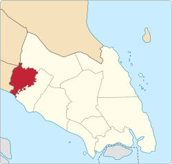 Location of Tangkak District in Johor | ||
 Tangkak District Location of Tangkak District in Malaysia | ||
| Coordinates: 2°16′N 102°33′E / 2.267°N 102.550°ECoordinates: 2°16′N 102°33′E / 2.267°N 102.550°E | ||
| Country |
| |
| State |
| |
| Seat | Tangkak | |
| Local area government(s) | Tangkak District Council | |
| Government | ||
| • District officer | Ab.Han Ramin | |
| Area[1] | ||
| • Total | 970.24 km2 (374.61 sq mi) | |
| Population (2010)[2] | ||
| • Total | 129,280 | |
| • Density | 130/km2 (350/sq mi) | |
| Time zone | UTC+8 (MST) | |
| • Summer (DST) | UTC+8 (Not observed) | |
| Postcode | 849xx | |
| Calling code | +6-06 | |
| Vehicle registration plates | J | |

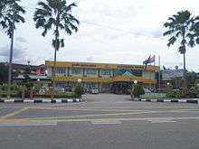
The Tangkak District is a district in Johor, Malaysia. The district capital is Tangkak Town. The district covers Tangkak Town, Tanjung Agas, Kesang, Sungai Mati, Serom, Sagil and Bukit Gambir.
History
The district was the northern part of the Muar district which was separated from the southern part by the Muar River.[3] A ceremony headed by the sultan on 9 June 2008 saw the official proclamation of that northern part becoming Johor's 10th district named Ledang District.[4] The district was then renamed Tangkak District at the end of 2015.[5]
Administrative divisions
Tangkak District is divided into 6 mukims:
- Bukit Serampang
- Grisek
- Kesang
- Kundang
- Serom
- Tangkak Town
Townships
- Tangkak
- Kesang
- Tanjung Agas
- Bukit Gambir
- Sungai Mati
- Parit Bunga
- Bukit Kangkar
- Pekan Rawang
- Bukit Serampang
- Kundang Ulu
- Serom
- Kesang,Tg Gading
- Sagil
- Kebun Baharu
- Gerisek
Federal Parliament and State Assembly Seats
List of Tangkak district representatives in the Federal Parliament (Dewan Rakyat)
| Parliament | Seat Name | Member of Parliament | Party |
|---|---|---|---|
| P144 | Ledang | Syed Ibrahim Syed Noh | Pakatan Harapan (PKR) |
List of Tangkak district representatives in the State Legislative Assembly (Dewan Undangan Negeri)
| Parliament | State | Seat Name | State Assemblyman | Party |
|---|---|---|---|---|
| P144 | N9 | Gambir | Muhyiddin Yassin | Pakatan Harapan (PPBM) |
| P144 | N10 | Tangkak | Ee Chin Li | Pakatan Harapan (DAP) |
| P144 | N11 | Serom | Faizul Amri Adnan | Pakatan Harapan (AMANAH) |
Economy
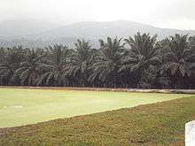
The main economy activities in the district are lifestyle tourism, adventure sports, light manufacturing and agriculture.[6] Main industrial areas in the district are Desa Serom, Desa Sungai Mati, Gerisek, Sagil and Tangkak Industrial Areas.[7]
Tourist attractions
Mount Ophir National Park
One of the main tourist attractions of Tangkak is the Gunung Ledang National Park. The park is situated 170 km from Johor Bahru and has an area of 107 km². The park has two entry points, one in Sagil, Johor and the other in Asahan, Melaka. Mount Ophir's peak, which is 1276 m above sea level is the highest point in the park and Johor. Mount Ophir is also the 64th highest mountain in Malaysian and has been climbed by many people. Sagil Waterfall, which is also in the park is a famous picnic site. Mount Ophir is also widely recognised as a friendly training venue for amateur (or beginners) mountain hikers/climbers.
See also
References
- ↑ "Profil Daerah". ptj.johor.gov.my.
- ↑ "Population Distribution and Basic Demographic Characteristics, 2010" (PDF). Department of Statistics, Malaysia. Archived from the original (PDF) on 22 May 2014. Retrieved 19 April 2012.
- ↑ "Ledang becomes 10th district". Archived from the original on 2012-10-05.
- ↑ "Ledang set to become Johor's newest district". The Star Online. Star Media Group Berhad. 1 June 2008. Retrieved 24 July 2016.
- ↑ "Johor's administrative capital Nusajaya to be renamed Iskandar Puteri". Straits Times. Singapore Press Holdings Ltd. 7 December 2015. Retrieved 24 July 2016.
- ↑ "Muafakat ke Arah #Johor Berkemajuan" (PDF). Muafakat Johor (in Malay). Retrieved 17 March 2018.
- ↑ http://jpbd.johor.gov.my/images/jpbd_DokumenTerbitan/Handbook.pdf
| Wikimedia Commons has media related to Tangkak. |
| |
Not Available (★Kangar) | |
| |
| |
☆Kuala Lumpur, Labuan and Putrajaya are Federal Territories (Malaysia) and did not have districts. italics for districts created after 2010 census. | |