Langhorne, Pennsylvania
| Langhorne | |
|---|---|
| Borough | |
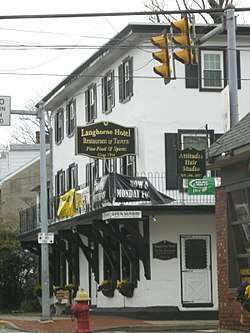 The Langhorne Hotel | |
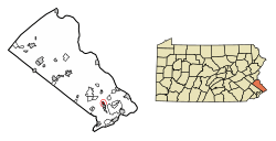 Location of Langhorne in Bucks County, Pennsylvania. | |
 Langhorne Location of Langhorne in Pennsylvania  Langhorne Langhorne (the US) | |
| Coordinates: 40°10′39″N 74°55′08″W / 40.17750°N 74.91889°WCoordinates: 40°10′39″N 74°55′08″W / 40.17750°N 74.91889°W | |
| Country | United States |
| State | Pennsylvania |
| County | Bucks |
| Incorporated | 1876 |
| Area[1] | |
| • Total | 0.49 sq mi (1.28 km2) |
| • Land | 0.49 sq mi (1.27 km2) |
| • Water | 0.00 sq mi (0.01 km2) |
| Elevation | 213 ft (65 m) |
| Population (2010) | |
| • Total | 1,622 |
| • Estimate (2016)[2] | 1,589 |
| • Density | 3,229.67/sq mi (1,247.05/km2) |
| Time zone | UTC-5 (Eastern (EST)) |
| • Summer (DST) | UTC-4 (EDT) |
| ZIP Codes | 19047, 19053 |
| Area code(s) | 215 and 267 |
| FIPS code | 42-41392 |
| Website |
www |
Langhorne is a borough in Bucks County, Pennsylvania, United States. The population was 1,622 at the 2010 census.
The name "Langhorne" is used broadly to describe the majority of surrounding Middletown Township, which for the most part uses Langhorne's ZIP code of 19047. Sesame Place, while physically located in surrounding Middletown Township, has Langhorne as its mailing address.
Langhorne Borough is approximately six miles west of the Delaware River.
Langhorne Manor is a separate borough that borders Langhorne proper to the south.
History
Langhorne began in the 17th century when Jack Alexander built his house in the area. The road from Bristol grew into a very important transportation center between Trenton and Philadelphia in the later 18th century and 19th century. Langhorne eventually became the stagecoach transportation hub of Bucks County, transporting people between Trenton and Philadelphia and was then known as Four Lanes End.
The village became known as Attleborough until 1876, when it was incorporated and named for Jeremiah Langhorne,[3] an early resident of the area and former chief justice of the Pennsylvania Supreme Court.
In the late 19th century and early 20th century, Langhorne continued to grow as wealthy Philadelphians constructed large homes and businesses along Maple and Bellevue Avenues.
The Langhorne Historic District, former Langhorne Library, Joseph Richardson House, and Tomlinson-Huddleston House are listed on the National Register of Historic Places.[4]
Langhorne was the base of eGames, the publisher of the cult classic Speedy Eggbert.
Geography
Langhorne Borough is located at 40°10′39″N 74°55′8″W / 40.17750°N 74.91889°W (40.177409, -74.918880).[5]
According to the United States Census Bureau, the borough has a total area of 0.5 square miles (1.3 km2), all land.
The northern border of Langhorne follows the Neshaminy Creek.
Demographics
| Historical population | |||
|---|---|---|---|
| Census | Pop. | %± | |
| 1880 | 558 | — | |
| 1890 | 727 | 30.3% | |
| 1900 | 801 | 10.2% | |
| 1910 | 895 | 11.7% | |
| 1920 | 1,067 | 19.2% | |
| 1930 | 1,147 | 7.5% | |
| 1940 | 1,221 | 6.5% | |
| 1950 | 1,579 | 29.3% | |
| 1960 | 1,461 | −7.5% | |
| 1970 | 1,673 | 14.5% | |
| 1980 | 1,697 | 1.4% | |
| 1990 | 1,361 | −19.8% | |
| 2000 | 1,981 | 45.6% | |
| 2010 | 1,622 | −18.1% | |
| Est. 2016 | 1,589 | [2] | −2.0% |
| Sources:[6][7][8] | |||
At the 2010 census, the borough was 86.4% White, 8.0% Black or African American, 0.1% Native American, 1.5% Asian, and 1.5% were two or more races. 2.3% of the population were of Hispanic or Latino ancestry .
At the 2000 census,[7] there were 1,981 people, 552 households and 338 families residing in the borough. The population density was 4,016.3 per square mile (1,561.0/km²). There were 649 housing units at an average density of 1,315.8 per square mile (511.4/km²).
There were 552 households, of which 25.9% had children under the age of 18 living with them, 47.5% were married couples living together, 9.8% had a female householder with no husband present, and 38.6% were non-families. 31.7% of all households were made up of individuals and 8.7% had someone living alone who was 65 years of age or older. The average household size was 2.40 and the average family size was 3.07.
Age distribution was 26.2% under the age of 18, 10.4% from 18 to 24, 30.8% from 25 to 44, 21.8% from 45 to 64, and 10.8% who were 65 years of age or older. The median age was 34 years. For every 100 females there were 117.5 males. For every 100 females age 18 and over, there were 107.1 males.
The median household income borough was $56,389, and the median family income was $75,429. Males had a median income of $48,125 versus $31,759 for females. The per capita income for the borough was $21,479. About 2.6% of families and 3.0% of the population were below the poverty line, including 3.0% of those under age 18 and 4.7% of those age 65 or over.
Climate
During the summer months, frequent episodes of high humidity occur. Occasionally, heat index values exceed 100 °F (38 °C). On average, the wettest month of the year is July which corresponds with the annual peak for thunderstorm activity. During the winter months, wind chill values occasionally fall below 0 °F (-18 °C). On average, the snowiest month of the year is February which corresponds with the annual peak for nor'easter activity.
| Climate data for Langhorne Borough, Pennsylvania (1981 – 2010 averages). Elevation 216 ft (66 m). | |||||||||||||
|---|---|---|---|---|---|---|---|---|---|---|---|---|---|
| Month | Jan | Feb | Mar | Apr | May | Jun | Jul | Aug | Sep | Oct | Nov | Dec | Year |
| Average high °F (°C) | 40.1 (4.5) |
43.4 (6.3) |
51.6 (10.9) |
63.5 (17.5) |
73.0 (22.8) |
82.2 (27.9) |
86.4 (30.2) |
84.8 (29.3) |
77.9 (25.5) |
66.6 (19.2) |
55.6 (13.1) |
44.5 (6.9) |
64.1 (17.8) |
| Average low °F (°C) | 23.7 (−4.6) |
25.6 (−3.6) |
32.2 (0.1) |
41.7 (5.4) |
50.9 (10.5) |
60.9 (16.1) |
65.8 (18.8) |
64.4 (18) |
56.9 (13.8) |
45.1 (7.3) |
36.8 (2.7) |
28.3 (−2.1) |
44.4 (6.9) |
| Average precipitation inches (mm) | 3.55 (90.2) |
2.76 (70.1) |
4.19 (106.4) |
3.94 (100.1) |
4.30 (109.2) |
4.31 (109.5) |
5.15 (130.8) |
4.34 (110.2) |
4.34 (110.2) |
3.76 (95.5) |
3.57 (90.7) |
4.02 (102.1) |
48.23 (1,225) |
| Average snowfall inches (cm) | 7.9 (20.1) |
8.8 (22.4) |
3.8 (9.7) |
0.7 (1.8) |
0.0 (0) |
0.0 (0) |
0.0 (0) |
0.0 (0) |
0.0 (0) |
0.0 (0) |
0.5 (1.3) |
3.9 (9.9) |
25.6 (65.2) |
| Source: PRISM[9] | |||||||||||||
Notable people
- Nolan Jones, drafted by the Cleveland Indians organization
- Ryan Arcidiacono, 2016 NCAA Division I Basketball Tournament champion as a star point guard for Villanova.
- Harry G. Frankfurt, 20th century American philosopher
- Days Away, indie rock band
- Chris Cole, professional skateboarder
- James Franklin, Head Coach of Penn State University Football Team, attended Neshaminy High School
- Matt and Chris Bahr, former NFL kickers, Neshaminy and Penn State graduates.[10]
- Bob Grupp, former NFL football player
- Edward Hicks, born in Attleboro (now Langhorne), devout Quaker and artist, known for his painting The Peaceable Kingdom.[11]
- David M. O'Connell, bishop
- Bill O'Neill (bowler), professional bowler, 7-time PBA Tour titleist[12]
- Langhorne Slim, folk rock singer
- Catie Turner, American Idol (season 16) Contestant.
- Len Barker, former MLB baseball player, pitched the 10th perfect game in baseball history during the 1981 season as member of Cleveland Indians, Neshaminy High graduate
References
- ↑ "2016 U.S. Gazetteer Files". United States Census Bureau. Retrieved Aug 13, 2017.
- 1 2 "Population and Housing Unit Estimates". Retrieved June 9, 2017.
- ↑ Gannett, Henry (1905). The Origin of Certain Place Names in the United States. U.S. Government Printing Office. p. 181.
- ↑ National Park Service (2010-07-09). "National Register Information System". National Register of Historic Places. National Park Service.
- ↑ "US Gazetteer files: 2010, 2000, and 1990". United States Census Bureau. 2011-02-12. Retrieved 2011-04-23.
- ↑ "Census of Population and Housing". U.S. Census Bureau. Retrieved 11 December 2013.
- 1 2 "American FactFinder". United States Census Bureau. Retrieved 2008-01-31.
- ↑ "Incorporated Places and Minor Civil Divisions Datasets: Subcounty Resident Population Estimates: April 1, 2010 to July 1, 2012". Population Estimates. U.S. Census Bureau. Archived from the original on 17 June 2013. Retrieved 11 December 2013.
- ↑ "PRISM Climate Group, Oregon State U". prism.oregonstate.edu. Retrieved 30 December 2017.
- ↑ "NFL Recognizes Neshaminy High School Graduates Who Played In Super Bowl - LevittownNow.com". 6 February 2016. Retrieved 30 December 2017.
- ↑ Who Was Who in America, Historical Volume, 1607-1896. Chicago: Marquis Who's Who. 1963.
- ↑ "PBA.com". Professional Bowlers Association. Retrieved 2015-06-24.
External links
| Wikimedia Commons has media related to Langhorne, Pennsylvania. |
| Wikinews has related news: Fairy-in-training debuts at Sesame Place today |

