South Lampung Regency
| South Lampung Regency Kabupaten Lampung Selatan | ||
|---|---|---|
| Regency | ||
| ||
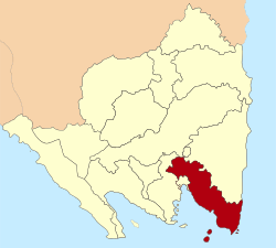 Location within Lampung | ||
| Coordinates: 5°33′45″S 105°32′51″E / 5.5624299°S 105.5475311°E | ||
| Country | Indonesia | |
| Province | Lampung | |
| Capital | Kalianda | |
| Government | ||
| • Regent | Zainudin Hasan | |
| • Vice Regent | Nanang Ermanto | |
| Area | ||
| • Total | 2,109.74 km2 (814.58 sq mi) | |
| Population (2014) | ||
| • Total | 959,126 | |
| • Density | 450/km2 (1,200/sq mi) | |
| Time zone | UTC+7 (IWST) | |
| Area code | (+62) 727 | |
| Website |
lampungselatankab | |


South Lampung Regency (Indonesian: Kabupaten Lampung Selatan) is a regency of Lampung, Sumatra, Indonesia, a strip of land surrounding the provincial capital of Bandar Lampung on its northern and eastern sides, and bounded to the west by the new Pesawaran Regency and to the south by the Sunda Strait; as such it is a major transit corridor to/from Java island. It has an area of 2,109.74 km2, and a population at the 2010 Census of 909,989;[1] the latest official estimate (as at January 2014) is 956,126. The capital lies at Kalianda.
The regency has seen a population influx as migrants escape the crushing population densities and everyday struggles of living in the massive urban paralysis of Greater Jakarta, its along with Bandar Lampung's character is increasingly reflecting the cosmopolitan makeup of Jakartans rather than the surrounds of a typical provincial capital and hinterland. This has resulted in flaring of ethnic tensions, including rioting.[2]
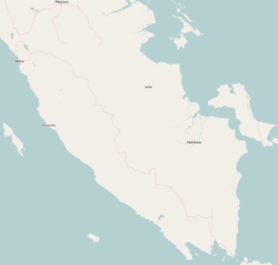
Administrative Districts
South Lampung Regency consists of seventeen districts (kecamatan), tabulated below with their populations at the 2010 Census:[3]
|
|
|
The districts are sub-divided into 3 kelurahan and 248 desa.
History
Pesawaran Regency, formerly that part of South Lampung Regency lying to the west of Bandar Lampung, was carved out of it in 2007.
In January 2011, tens of thousands of inhabitants of South Lampung had to be evacuated by the South Lampung Disaster Mitigation Agency (BPBD) in the seven districts of Kalianda, Rajabasa, Katibung, Sidomulyo, Ketapang, Sragi and Palas due to volcanic ash from the Mount Anak Krakatau.[4] There is an observation station at Hargopancuran village in South Lampung used to monitor activity.
References
- ↑ Biro Pusat Statistik, Jakarta, 2011.
- ↑ http://www.thejakartapost.com/news/2012/11/23/five-arrested-causing-s-lampung-riots.html
- ↑ Biro Pusat Statistik, Jakarta, 2011.
- ↑ "Residents to be evacuated as Mt. Anak Krakatau spews ash". Jakarta Post, Bandarlampung. 11 January 2011. Retrieved 22 February 2011.
External links
| Wikimedia Commons has media related to South Lampung Regency. |
Regencies and cities of Lampung | ||
|---|---|---|
Capital: Bandar Lampung | ||
| Regencies | ||
| Cities | ||