Kopaonik
| Kopaonik | |
|---|---|
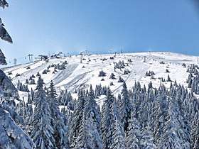 Pančić's Peak, during winter | |
| Highest point | |
| Peak | Pančić's Peak |
| Elevation | 2,017 m (6,617 ft) |
| Coordinates | 43°16′09″N 20°49′21″E / 43.26917°N 20.82250°ECoordinates: 43°16′09″N 20°49′21″E / 43.26917°N 20.82250°E |
| Geography | |
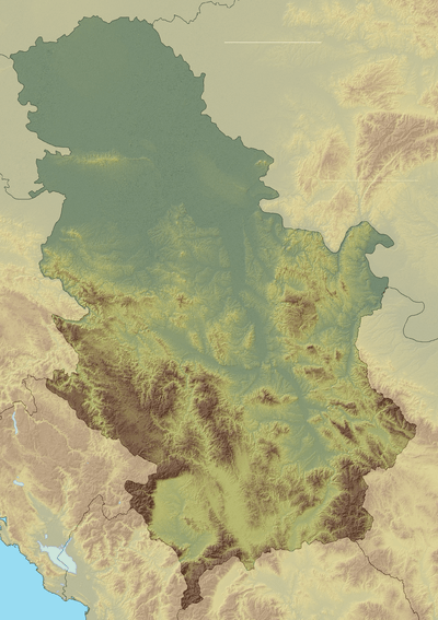 Kopaonik Serbia and Kosovo | |
| Location | Serbia and Kosovo[a] |
|
IUCN category II (national park) | |
 Kopaonik National Park | |
| Area | 121.06 km2 (46.74 sq mi) |
| Established | 1981 |
Kopaonik (Serbian Cyrillic: Копаоник, Serbian pronunciation: [kɔpaɔ̌niːk]; Albanian: Kopaoniku) is a mountain in Serbia and Kosovo. It is the largest mountain range in Serbia. The highest point is the Pančić's Peak with 2,017 m (6,617 ft).
Kopaonik is a major ski resort in Serbia is the largest in Southeast Europe. There are 25 ski lifts with capacity of 32,000 skiers per hour.[1]
The central part of the Kopaonik plateau was declared a national park in 1981 which today covers an area of 121.06 km2 (46.74 sq mi).
Geography
Stretching for 75 km (47 mi) in the north-south direction, between the rivers of Lab and Sitnica on the south and Jošanica on the north, Kopaonik is the largest and longest mountain range in Serbia.[2][3] It belongs to the region of Raška.[4][5] The Kopaonik mountain massif (Kopaoničke planine) includes the mountains of Kopaonik, Željin, Goč and Stolovi.[2] The Pančić's Peak, with 2,017 m (6,617 ft), is the highest point of the mountain.[3]
Climate
Kopaonik has a subarctic climate (Köppen climate classification: Dfc) with short, fresh summers, and long, cold winters with abundant snowfall. The snow season lasts from November to May, while there are around 200 sunny days.[6]
| Climate data for Kopaonik, 1981-2010 | |||||||||||||
|---|---|---|---|---|---|---|---|---|---|---|---|---|---|
| Month | Jan | Feb | Mar | Apr | May | Jun | Jul | Aug | Sep | Oct | Nov | Dec | Year |
| Average high °C (°F) | −0.9 (30.4) |
−1.4 (29.5) |
1.5 (34.7) |
5.8 (42.4) |
11.3 (52.3) |
14.7 (58.5) |
17.0 (62.6) |
17.4 (63.3) |
13.1 (55.6) |
9.3 (48.7) |
3.8 (38.8) |
−0.1 (31.8) |
7.6 (45.7) |
| Daily mean °C (°F) | −4.6 (23.7) |
−5.1 (22.8) |
−2.2 (28) |
2.0 (35.6) |
7.3 (45.1) |
10.6 (51.1) |
12.7 (54.9) |
12.8 (55) |
8.7 (47.7) |
5.0 (41) |
0.0 (32) |
−3.5 (25.7) |
3.6 (38.5) |
| Average low °C (°F) | −7.7 (18.1) |
−8.2 (17.2) |
−5.3 (22.5) |
−1.2 (29.8) |
3.5 (38.3) |
6.6 (43.9) |
8.4 (47.1) |
8.7 (47.7) |
5.1 (41.2) |
1.7 (35.1) |
−2.9 (26.8) |
−6.4 (20.5) |
0.2 (32.4) |
| Average precipitation mm (inches) | 62.0 (2.441) |
58.7 (2.311) |
64.8 (2.551) |
74.7 (2.941) |
108.8 (4.283) |
124.7 (4.909) |
92.1 (3.626) |
94.3 (3.713) |
66.7 (2.626) |
46.2 (1.819) |
68.9 (2.713) |
58.9 (2.319) |
920.8 (36.252) |
| Source: Republic Hydrometeorological Service of Serbia[7] | |||||||||||||
Earthquakes
Kopaonik was hit 5 times by earthquakes of Mercalli intensity VII to VIII between 1978 and 1985.[8] The 1983 earthquake had an intensity of VIII (Severe) and affected 7 villages, leaving 200 homeless, and 1,200 buildings and dwellings damaged.[9]
Name
Due to its rich mines, Kopaonik was originally named Silver Mountain (Serbian: Сребрна планина, translit. Srebrna planina) and that name was also used by the Romans, Venetians and Ottomans. Its current name, originally Kopalnik, is also connected to the ore mining as it comes from kopati, Serbian for digging.[3]
History
Kopaonik has a rich historical heritage.[10] Oldest findings are from the Paleolithic and already show that local people used metals. Localities include Bela Stena, Veliki Krš and Jasova Bačija. Neolithic remains were discovered on the localities of Gornji Kaznovići (Rosulja and Lug), Greblje, Tomovićko Brdo and the Neolithic range of Beglučka.[3]
The mining fully developed during the Classical antiquity. The Romans began to dig the first proper mines and to build the surrounding settlements. The remains from this period include the archaeo-metallurgic complex Zajačak and the locality of Dobrinac in Rvati. Dobrinac originates from the 3rd or 4th century AD and it was the administrative center of the mining and metallurgic operations on the western slope of the mountain.[3]
The area remained an important mining center in the Middle Ages and by the 14th century it became the main mining area of Serbia. Emperor Dušan visited the Silver Mountain in August 1336. In 1412 despot Stefan Lazarević granted the Law on mines which mentions the mines of gold, silver, iron, copper, lead and zinc in the area. By that time, the mountain already hosted the colonies of Saxons, Kotorans and Ragusians.[3] Besides old churches and monasteries like Đurđevi stupovi, Studenica monastery, Sopoćani and Gradac Monastery,[10] there are also several early and medieval fortresses locally, built by Serbian dynasties. The nearest Serbian medieval castle is Maglič.
During the Ottoman period, from the 15th century, the mining gradually ceased, but they developed the thermal springs, building Turkish baths. Remains of one are found in modern spa of Jošanička Banja.[3]
First scientific exploration of the mountain's flora came in 1836-38 when the geologist Ami Boué visited the mountain. He made a collection of Kopaonik's plant life which is today kept in the Imperial Natural History Museum in Vienna. Botanist Josif Pančić gave the greatest scientific contribution to the plant life on Kopaonik. In 1851 he explored the mountain for the first time, followed by another 18 expeditions.[3]
During World War II the Yugoslav Partisans were active in the region.[11]
With territorial reorganization in the mid-1950s, the southern parts of Kopaonik were to be ceded from NR Serbia to its autonomous province Kosovo and Metohija.[12] In 1959, Leposavić was incorporated into the province.[13]
In Pančić's honor, marking the 100th anniversary of his first expedition, the highest point was renamed from Milan's Peak (Milanov vrh) to Pančić's Peak in 1951. A mausoleum was built on the peak and the remains of Pančić and his wife were reinterred in it. They were buried in the coffins made of Serbian spruce, which Pančić discovered.[3]
National park
Geography
In 1981, due to its location, climate, rich forests, variety of herbs, and area for holiday and recreation, 121.06 km2 (46.74 sq mi) of the range were proclaimed a national park.[3][6][14]
The national park is situated on a relatively flat region, at an altitude of about 1,700 m (5,577 ft). This central Kopaonik plateau is called Suvo Rudište. It is surrounded by mountain peaks. To the north and northwest of this plateau stretches Banjski Kopaonik, which is the location of Jošanička Banja spa, whose strong springs' waters reach the temperature of 88 °C (190 °F). Directly below the Suvo Rudište plateau starts the valley of the Samokovska River, with its steep run, numerous rapids, falls and gorges. Kopaonik has over 200 sunny days annually and over 160 days covered by snow.[15] There is also the Jelovarnik falls, one of the highest in Serbia.
Kopaonik has several excellent natural lookouts: Suvo Rudište, Gobelja, Karaman, Kukavica, Vučak and Treska. On a clear day, a distant mountains in Montenegro, Bulgaria and Albania can be observed.[3]
There are 13 localities within the park which are declared a strict nature reserves: Barska Reka, Bele Stene, Vučak, Gobelja, Duboka, Jankove Bare, Jelak, Jelovarnik, Kozje Stene, Mrkonje, Metođe, Samokovska Reka and Suvo Rudište.[3]
Soil erosion is a threat as there is a lot of logging and deforestation in the park.
Wildlife
Plant life
Kopaonik's flora has a large number of autochthonous plant species (Balkan beech, fir, spruce, yew, several kinds of maple, pine and oak). Deciduous forests and native coniferous woodland make up most of the forested land in the park. There are also forests of willow, poplar, common hornbeam, durmast oak and Turkey oak. In total, there are 1,600 plant species in the park, out of which 200 grow only on Kopaonik. It also includes over 200 species of fungi. Special value of Kopaonik in terms of biological diversity is that 11.9% of the high mountain endemic species in the Balkans inhabits the mountain. Endemic species which grow only on Kopaonik include Kopaonik's houseleek, Kopaonik's violet and Pančić's bittercress. Other endemites include sea thrift, Balkan docks (Rumex balcanicus), Pancicia serbica, Blečić's columbine (Aquilegia blecicii), Bosnian marsh orchid, Bulgarian achillea (Achillea bulgarica), Alyssum, aconite and Yugoslav bell (Edrianthus jugoslavicus).[3][14]
There are several "botanical monuments" in the park. Those are trees which are very old, large in size and still vital. Among them are the fir "of the hundred elbows" in Samokovska Reka, a spruce in Gobeljska Reka and three mountain sycamores in Kriva Reka.[3]
Animal life
The fauna is also diverse but its concentration varies, depending on the quality of the habitat.
An endemic butterfly, the Balkan postman, lives on the mountain.[3]
Kopaonik has 175 species of birds, including the protected ones like woodpecker and thrush.[3] Other species include rock partridge, scops owl, red-backed shrike and wood lark.
Major representatives of the mammalian fauna are wild boar and wild cat.[3]
Ski resort
| Kopaonik ski resort | |
|---|---|
 Nebeske Stolice hotel at Kopaonik | |
| Location |
Kopaonik, |
| Nearest city | Brus, Serbia |
| Coordinates | 43°16′9″N 20°49′21″E / 43.26917°N 20.82250°E |
| Top elevation | 2,017 m |
| Base elevation | 1,770 m |
| Skiable area | 75 km |
| Runs | 25 |
| Longest run | 3.5 km |
| Lift system | 28 total (8-passenger gondola (u/c), 3 high-speed 6-passenger Superchairs, 7 High-speed quad chairs, 2 double chairs, 11 Surface and 3 kid-surface) |
| Lift capacity | 32,000/hour |
| Website | Kopaonik |
Kopaonik is the largest centre of winter tourism in Serbia.[2] Sports and recreation are key factors to the tourism of Kopaonik. Kopaonik is mainly a destination for skiing and snowboarding. There are various other activities as well, such as tennis. There are several hotels, one hostel, cafes, bars and night clubs.
It has 27 ski lifts, with 75 km (47 mi) of ski slopes for all categories[16]. Currently under construction is a gondola that is planned to connect Brzece and the ski resort.[17]
The duration and quality of snowfall and skiing grounds have attracted an increasing number of guests. Kopaonik has mild winters with high levels of snowfall.[18]
There are on average about 200 sunny days annually with 160 days covered with snow.[18]
There is also a music Big Snow Festival from March 23 to March 29 every year. The festival gathers international reggae, jazz and electronic music performers.[18] The ski resort has a Snow Park for extreme skiers and snowboarders.[19] The park has expanses of grassland, forests composed of a variety of tree species, beauty spots, and river gorges. The snow blanket lasts a long time on this mountain and there are favorable conditions for the expansion of winter tourism there.[20] The tourist resort on the Kopaonik includes hotels, rest houses, chairlifts, ski slopes, spa's, and other tourist facilities.
Transportation
Kopaonik is well-connected with the main transport routes in Serbia. The central part of Kopaonik with the tourist center and ski slopes are linked with the Ibar highway, and the nearest international airport is in Niš. A public heliport is located in a military base half a mile north of the resort.
See also
- Kopaonik (Raška), a village in the municipality of Raška, at Kopaonik Mountain
- Majdan (mountain in Kosovo)
- 1983 Kopaonik earthquake
References
- ↑ "Turistički centar Kopaonik". Tckopaonik.com. Retrieved 2013-09-16.
- 1 2 3 Ristanović 2005, p. 367.
- 1 2 3 4 5 6 7 8 9 10 11 12 13 14 15 16 17 Dimitrije Bukvić (10 July 2017), "Blago srebrne planine", Politika (in Serbian), pp. 01 & 08
- ↑ Milija K. Maliković (1971). Raška i okolina: Geografsko-istorijski pregled. Istorijski arhiv Kraljevo.
- ↑ Ristanović 2005, p. 269.
- 1 2 Ristanović 2005, p. 368.
- ↑ "SREDNJE MESEČNE, GODIŠNJE I EKSTREMNE VREDNOSTI 1961 - 1990". October 2017.
- ↑ Roux, Michel (1992). Les Albanais en Yougoslavie: Minorité nationale, territoire et développement (in French). Les Editions de la MSH. p. 93. ISBN 9782735104543.
- ↑ Associated Press (13 September 1983). "Earthquake in Serbia". The New York Times.
- 1 2 Archived November 6, 2011, at the Wayback Machine.
- ↑ Branko N. Bošković (1968). Narodnoosvobodilačka borba u Ibarskom bazenu: (kosovsko-mitrovački i studenički srez). Zajednica naučnih ustanova Kosova i Metohije.
- ↑ Jovan Đ. Marković (1967). Geografske oblasti Socijalističke Federativne Republike Jugoslavije. Zavod za izdavanje udžbenika Socijalističke Republike Srbije. p. 408–412.
- ↑ Miloš Macura (1989). Problemi politike obnavljanja stanovništva u Srbiji. Srpska akademija nauka i umetnosti. p. 74.
- 1 2 Aleksandra Mijalković (18 June 2017), "O očuvanju naše prirodne baštine: najbolja zaštita u naconalnim parkovima", Politika-Magazin (in Serbian), pp. 3–6
- ↑ "Turistički centar Kopaonik". Tckopaonik.com. Retrieved 2013-09-16.
- ↑ http://www.eng.infokop.net/
- ↑ "Ski gondola će povezati Brzeće i vrh Kopaonika".
- 1 2 3 "Putovanja - Destinacije - Kopaonik - skijanje i uživanje - B92 Putovanja". B92. 2011-12-03.
- ↑ "Turistički centar Kopaonik". Tckopaonik.com. 2011-11-30. Retrieved 2013-09-16.
- ↑
Sources
- Ristanović, Slobodan (2005). Kroz Srbiju i Crnu Goru. КСЕ-НА. pp. 367-.
- Jovan Milićević (1965). "Kopaonik". Srbija: Znamenitosti i lepote. Književne novine.
- Jосип Панчић (1893). "Копаоник и његово подгорје". Из природе. Srpska književna zadruga.
- Stevan Nikolić (1998). Priroda i turizam Srbije: ekološka pitanja zaštite i razvoja. Eko centar.
External links
| Wikimedia Commons has media related to Kopaonik. |
- "Kopanik, Serbia". , British promotional video
- National Park Kopaonik
- British site promotion of Kopaonik
- Kopaonik Mountain Resort - Latest news, live photos and videos
- Kopaonik Ski Resort - news, photos, ski info, web cams, weather, accommodation, forum, impressions
- Kopaonik accommodation
- BirdLife Kopaonik factsheet
|  | |
(*) indicates location within Kosovo | ||