Drenica
| Drenica | |
|---|---|
| Historical region of Kosovo | |
 | |
| Country |
|
| Municipalities |
Drenas/Glogovac Skenderaj/Srbica |
| Area | |
| • Total | 668 km2 (258 sq mi) |
| Population (2011) | |
| • Total | 109,389 |
| • Density | 160/km2 (420/sq mi) |
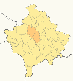
Drenica (Albanian: Drenicë, Drenica, Serbian Cyrillic: Дреница), also known as the Drenica Valley, is a hilly region in central Kosovo, covering roughly around 700 square kilometres (270 sq mi) of Kosovo's total area (6%). It consists of two municipalities, Glogovac and Skenderaj (sr. Srbica), and several villages in Klina, Kërligatë (sr. Krligate) village in Zubin Potok, Mitrovica (sr. Kosovska Mitrovica) and the area of Vučitrn. It is located west of the capital, Pristina.
According to the 2011 Census, the population of the region is 109,389, excluding the surrounding villages. Albanians form the absolute majority of the region.[1]
Geography
Drenica is located in the center of what is today Kosovo, in the western part of the region itself of Kosovo.[2] It is sometimes regarded as a region in its own right.
Middle Ages
Draškovina was the name of a medieval Serbian župa (county) that included parts of Metohija and northern Drenica.[3]
The area of Kosovo, including Drenica, was part of Vuk Branković's land during the fall of the Serbian Empire.[4] Drenica was first mentioned as a župa at the end of the Middle Ages.[5] It was first mentioned in 1413, when Đurađ Branković, his mother Mara, and brothers Đurađ and Lazar, endowed the village of Dobroševce to the Monastery of Saint Paul of Mount Athos. Despot Đurađ Branković (1427–1456) founded the Devič monastery in the region.
Early modern period
In the 18th century, Drenica was divided into gornja ("upper") and donja ("lower") Drenica.[5] The center of Upper Drenica is Sedlar, that of Lower Drenica, Lauša.[5]
Modern history
The villages surrounding the towns of Glogovac (Gllogoc) and Skenderaj (Srbica) were the birthplace of the ethnic Albanian separatist Kosovo Liberation Army (KLA) and a stronghold of Albanian nationalism. The KLA began armed operations in Drenica in 1996. A KLA stronghold during the 1998–99 Kosovo War, the region saw many armed conflicts against the security forces of FR Yugoslavia. The hilltop village of Likovac served as regional headquarters for the KLA until government forces recaptured it in an offensive in September 1998. The area around Čičavica also saw activity between government forces and the 114th Brigade of the KLA.
The Yugoslav army and paramilitary units used the Feronikel plant near Glogovac as a base for operations during the war. Before the war, the factory produced nickel and ore. After the Albanian workers were laid off or expelled, it was also used as a barracks and a fire base, in which cannons and rockets were fired against KLA positions. The plant was bombed by NATO forces on April 29, 1999, causing an unknown number of casualties and extensive damage.
Notable people
References
- ↑ Human Right Watch: Drenica Region
- ↑ Jovan Đ Marković (1967). Geografske oblasti Socijalističke Federativne Republike Jugoslavije. Zavod za izdavanje udžbenika Socijalističke Republike Srbije. p. 399.
- ↑ Душко Томић (2006). Положај СПЦ у конфликту на Косову и Метохији. Задужбина Андрејевић. p. 31. ISBN 978-86-7244-519-0.
- ↑ Вук Бранковић, 1372-1398. Штамп. у краљевско-српској државној штамп. 1888. p. 6.
- 1 2 3 Tatomir P. Vukanović (2001). Enciklopedija narodnog života, običaja i verovanja u Srba na Kosovu i Metohiji: VI vek - početak XX veka : više od 2000 odrednica. Vojnoizdavački zavod. p. 159.
Further reading
External links
| Wikimedia Commons has media related to Drenica. |
Coordinates: 42°33′31″N 20°48′45″E / 42.55861°N 20.81250°E