Pešter
| Pešter | |
|---|---|
 | |
| Highest point | |
| Elevation | 1,492 m (4,895 ft) [1] |
| Coordinates | 43°03′04″N 20°03′21″E / 43.051166°N 20.055833°ECoordinates: 43°03′04″N 20°03′21″E / 43.051166°N 20.055833°E |
| Geography | |
 Pešter | |
| Official name | Pestersko polje |
| Designated | 19 March 2006 |
| Reference no. | 1656[2] |
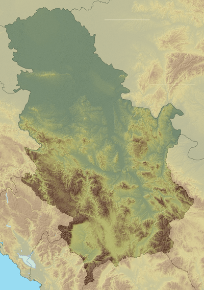
The Pešter plateau (Serbian: Пештерска висораван/Pešterska visoravan; Albanian: Rrafshnalta e Peshterit), or simply Pešter (Serbian Cyrillic: Пештер, pronounced [pɛ̌ʃtɛr]; Albanian: Peshter), is a karst plateau in southwestern Serbia, in the Raška (or Sandžak) region. It lies at the altitude of 1150–1492 m, (Kuljarski vrh) at 1492 meters. The territory of the plateau is mostly located in the municipality of Sjenica, with parts belonging to Novi Pazar and Tutin. The name of the region comes from the word pešter, which is a slavic word for cave.
Geography
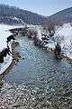
The plateau is actually a large field (Peštersko polje) surrounded by mountains of Jadovnik (1734 m), Zlatar (1627 m), Ozren (1693 m), Giljeva (1617 m), Javor (1519 m), Golija (1833 m), Žilindar (1616 m), Hum (1756 m), Ninaja (1462 m) and Jarut (1428 m). With the area of around 50 km2, Pešter field is the largest field in Serbia, and the highest one in the Balkans.[3] Rivers Uvac, Vapa, Jablanica and Grabovica flow through the plateau.[4] In the geologic past, the field was a large lake, of which only a small Sjenica lake near the village of Tuzinje remained.[3]
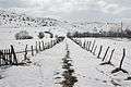
The soil is mostly karst interspersed with pastures. Economy of the area relies primarily on cattle breeding, chiefly sheep. Pešter is famous for its dairy products, especially the "Sjenica cheese" (Sjenički sir), as well as lamb and prosciutto.[4] The plateau is sparsely populated: most settlements are on the edge of the field, and the remainder is settled only during summer months.[3]
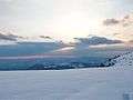
Pešter is famous for its microclimate, which is particularly harsh in the winter months. The lowest temperature in Serbia since measurements are taken, −39 °C (−38 °F) is measured at Karajukića Bunari village on 26 January 2006, beating the previous record of −38.4 °C (−37.1 °F) measured in Sjenica in 1954.[5]
In the near geological past, the field used to be a highland lake, which gradually drained through karst ruptures, leaving marshy remnants in the lowest parts, around the flow of sinking river Boroštica.[6] Those areas are home to a wet peatbog habitat unique for karst. On 1 May 2006, Ramsar included the wetland area of 3,455 hectares into its list of wetlands of international importance.[7] Pešter is home to a number of endangered species, such as the plants Fumana bonapartei, Halacsya sendtneri and Orchis tridentata. The only nesting place of Montagu's harrier in Serbia is in this area.[7]
Demographics
There are still some Albanian villages (Boroštica, Doliće and Ugao) in the Pešter region.[8] Factors such as some intermarriage undertaken by two generations with the surrounding Bosniak population along with the difficult circumstances of the Yugoslav wars (1990s) made local Albanians opt to refer to themselves in censuses as Bosniaks.[8]
Gallery


See also
References
- ↑ Mountains in Serbia Archived 2010-06-06 at the Wayback Machine.
- ↑ "Pestersko polje". Ramsar Sites Information Service. Retrieved 25 April 2018.
- 1 2 3 "Prirodni resursi" (in Serbian). Official web site of municipality of Sjenica. Archived from the original on 2010-06-26. Retrieved 2010-12-02.
- 1 2 "Sjenica-Pešter" (in Serbian). Tourist organization of Serbia. Archived from the original on 2007-10-06. Retrieved 2007-07-26.
- ↑ "Minus 39, oboren rekord" (in Serbian). Glas Javnosti. 2006-01-27. Retrieved 2007-07-26.
- ↑ "Peštersko polje". Serbian Tourist Organization. Archived from the original on 2012-09-10.
- 1 2 "The Annotated Ramsar List: Republic of Serbia". Ramsar Convention. Archived from the original on 2007-07-15. Retrieved 2007-07-26.
- 1 2 Andrea Pieroni, Maria Elena Giusti, & Cassandra L. Quave (2011). "Cross-cultural ethnobiology in the Western Balkans: medical ethnobotany and ethnozoology among Albanians and Serbs in the Pešter Plateau, Sandžak, South-Western Serbia." Human Ecology. 39. (3): 335. "The current population of the Albanian villages is partly "bosniakicised", since in the last two generations a number of Albanian males began to intermarry with (Muslim) Bosniak women of Pešter. This is one of the reasons why locals in Ugao were declared to be "Bosniaks" in the last census of 2002, or, in Boroštica, to be simply "Muslims", and in both cases abandoning the previous ethnic label of "Albanians", which these villages used in the census conducted during "Yugoslavian" times. A number of our informants confirmed that the self-attribution "Albanian" was purposely abandoned in order to avoid problems following the Yugoslav Wars and associated violent incursions of Serbian para-military forces in the area. The oldest generation of the villagers however are still fluent in a dialect of Ghegh Albanian, which appears to have been neglected by European linguists thus far. Additionally, the presence of an Albanian minority in this area has never been brought to the attention of international stakeholders by either the former Yugoslav or the current Serbian authorities."
External links
| Wikimedia Commons has media related to Pešter. |
- Ivanjica - Golija - Pešterska visoravan - Moravac – a hiking tour through Pešter and Golija (in Serbian)
- Rezervati prirode - Peštersko polje at the Institute for Nature Conservation of Serbia
|  | |
(*) indicates location within Kosovo | ||