Washington Township, Starke County, Indiana
| Washington Township | |
|---|---|
| Township | |
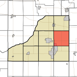 Location in Starke County | |
| Coordinates: 41°17′56″N 86°31′19″W / 41.29889°N 86.52194°WCoordinates: 41°17′56″N 86°31′19″W / 41.29889°N 86.52194°W | |
| Country |
|
| State |
|
| County | Starke |
| Government | |
| • Type | Indiana township |
| Area | |
| • Total | 36.19 sq mi (93.7 km2) |
| • Land | 36.13 sq mi (93.6 km2) |
| • Water | 0.06 sq mi (0.2 km2) 0.17% |
| Elevation[1] | 722 ft (220 m) |
| Population (2010) | |
| • Total | 3,003 |
| • Density | 83.1/sq mi (32.1/km2) |
| Time zone | UTC-6 (Central (CST)) |
| • Summer (DST) | UTC-5 (CDT) |
| ZIP codes | 46511, 46531, 46534 |
| Area code(s) | 574 |
| GNIS feature ID | 454020 |
Washington Township is one of nine townships in Starke County, in the U.S. state of Indiana.[2] As of the 2010 census, its population was 3,003 and it contained 1,201 housing units.[3]
Geography
According to the 2010 census, the township has a total area of 36.19 square miles (93.7 km2), of which 36.13 square miles (93.6 km2) (or 99.83%) is land and 0.06 square miles (0.16 km2) (or 0.17%) is water.[3]
Cities, towns, villages
- Bass Lake (north edge)
Unincorporated towns
- Oak Grove at 41°17′16″N 86°29′10″W / 41.287820°N 86.486121°W
- Ober at 41°16′15″N 86°31′28″W / 41.270875°N 86.524455°W
(This list is based on USGS data and may include former settlements.)
Adjacent townships
- Oregon Township (north)
- West Township, Marshall County (east)
- Union Township, Marshall County (southeast)
- North Bend Township (south)
- California Township (southwest)
- Center Township (west)
- Davis Township (northwest)
Cemeteries
The township contains these two cemeteries: Holy Cross and Swartzell.
Lakes
- Eagle Lake
Major highways
School districts
- Knox Community School Corporation
Political districts
- Indiana's 2nd congressional district
- State House District 17
- State Senate District 5
References
- United States Census Bureau 2008 TIGER/Line Shapefiles
- United States Board on Geographic Names (GNIS)
- IndianaMap
- ↑ "US Board on Geographic Names". United States Geological Survey. October 25, 2007. Retrieved 2017-05-09.
- ↑ "Washington Township". Geographic Names Information System. United States Geological Survey. Retrieved 2009-07-05.
- 1 2 "Population, Housing Units, Area, and Density: 2010 - County -- County Subdivision and Place -- 2010 Census Summary File 1". United States Census. Retrieved 2013-05-10.
External links
Places adjacent to Washington Township, Starke County, Indiana | |
|---|---|
Municipalities and communities of Starke County, Indiana, United States | ||
|---|---|---|
| City | ||
| Towns | ||
| Townships | ||
| CDPs | ||
| Other unincorporated communities | ||
| Footnotes | ‡This populated place also has portions in an adjacent county or counties | |
This article is issued from
Wikipedia.
The text is licensed under Creative Commons - Attribution - Sharealike.
Additional terms may apply for the media files.