Kohgiluyeh and Boyer-Ahmad Province
| Kohgiluyeh and Boyer-Ahmad Province استان کهگیلویه و بویراحمد | |
|---|---|
| Province | |
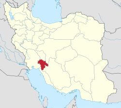 Location of Kohgiluyeh and Boyer-Ahmad within Iran | |
| Coordinates: 30°40′N 51°36′E / 30.67°N 51.60°ECoordinates: 30°40′N 51°36′E / 30.67°N 51.60°E | |
| Country |
|
| Region | Region 2 |
| Capital | Yasuj |
| Counties | 5 |
| Area | |
| • Total | 15,504 km2 (5,986 sq mi) |
| Population (2011)[1] | |
| • Total | 658,629 |
| • Density | 42/km2 (110/sq mi) |
| Time zone | UTC+03:30 (IRST) |
| • Summer (DST) | UTC+04:30 (IRST) |
| Main language(s) |
Official: Persian Majority:Lurish |
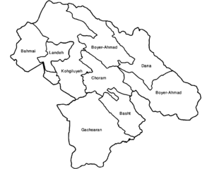
Kohgiluyeh and Boyer-Ahmad Province (Persian: استان کهگیلویه و بویراحمد, Ostān-e Kohgīrūye-o Būyer-Ahmad ) (Luri: استان کهگیلویه و بِیرَمَد, Ostān-e Kohgīrūye-o Beyramad ) is one of the thirty-one provinces of Iran. It is in the south-west of the country, in Iran's Region 2,[2] and its capital is Yasuj. The province covers an area of 15,563 square kilometers, and in 2006 had a population of 634,000. According to National Population and Housing Census population of Kohgiluyeh and Boyer-Ahmad in 2011 was 658,629.[1] The people mainly speak Lurish language. The counties of Kohgiluyeh and Boyer-Ahmad Province are Bahmai County, Landeh County, Boyer-Ahmad County, Charam County, Dana County, Basht County & Gachsaran County.
Geography

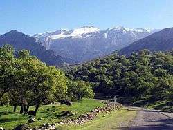
The province is mostly mountainous in terrain, part of the Zagros range. The highest point is the Dena summit with a height of 5,109 meters.
The mountain range of Dena, with more than 20 elevations and over 4000 meters high above the sea level, is, in fact, the great Himalayas in miniature. The mountain range, which is located in Kohgiluyeh va Buyer Ahmad province, is covered with oak forests. Natural springs, singing of the birds, and fresh air fascinate all lovers of nature. Another mountain is Khamin or Khami that is located in Gachsaran country.
Administrative divisions

Colleges and universities
References
- 1 2 Selected Findings of the 2011 National Population and Housing Census Archived 2014-11-14 at the Wayback Machine.
- ↑ "همشهری آنلاین-استانهای کشور به ۵ منطقه تقسیم شدند (Provinces were divided into 5 regions)". Hamshahri Online (in Persian). 22 June 2014. Archived from the original on 23 June 2014.
External links
| Wikimedia Commons has media related to Kohgiluyeh and Boyer-Ahmad Province. |
- Official website of Kohgiluyeh and Buyer Ahmad Governorship
- A Boyer-Ahmad-i folk-song sung by Shusha Guppy in the 1970s: Girl from Boyer-Ahmad-i Tribe.
Places adjacent to Kohgiluyeh and Boyer-Ahmad Province | ||||||||||
|---|---|---|---|---|---|---|---|---|---|---|
| ||||||||||
| Capital |  | ||||||||||||||||
|---|---|---|---|---|---|---|---|---|---|---|---|---|---|---|---|---|---|
| Counties and cities |
| ||||||||||||||||
| Sights |
| ||||||||||||||||
| populated places | |||||||||||||||||
Lurish languages in Iran and Iraq | ||
|---|---|---|
|  | |
Source for percentages is the Ethnologue. | ||