Kendujhar district
| Kendujhar Keonjhar | |
|---|---|
| District | |
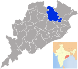 Location in Odisha, India | |
| Coordinates: 21°37′59″N 85°36′00″E / 21.633°N 85.6°ECoordinates: 21°37′59″N 85°36′00″E / 21.633°N 85.6°E | |
| Country |
|
| State | Odisha |
| Headquarters | Kendujhar |
| Government | |
| • Collector | Ashish Thakare IAS |
| • Member of Parliament | Sakuntala Laguri, BJD |
| Area | |
| • Total | 8,240 km2 (3,180 sq mi) |
| Elevation | 480 m (1,570 ft) |
| Population (2011) | |
| • Total | 1,802,777 |
| • Rank | 8 |
| • Density | 217/km2 (560/sq mi) |
| Languages | |
| • Official | Odia |
| • Other Local Language | Ho, Kudmali |
| Time zone | UTC+5:30 (IST) |
| PIN | 758 xxx |
| Vehicle registration | OD-09 |
| Sex ratio | 0.987 ♂/♀ |
| Literacy | 69% |
| Lok Sabha constituency | Keonjhar (ST) |
| Vidhan Sabha constituency | 6 |
| Climate | Aw (Köppen) |
| Precipitation | 1,535.5 millimetres (60.45 in) |
| Website |
www |
| This article is part of a series on |
| Odisha |
|---|
 |
| Governance |
|
| Topics |
| GI Products |
|
Districts Divisions |
|
|
Kendujhar District, also known as Keonjhar District is an administrative district of Odisha. The district is one of the 5 scheduled areas of Odisha. The town of Kendujhar (or Kendujhargarh) is the district headquarters. The district has 3 Subdivisions, Anandapur, Champua, and Keonjhar.[1]
Geography
Keonjhar is a land locked district situated in the northern part of Orissa. It is bounded by Mayurbhanj District, Balasore District and Bhadrak District to the east, Jajpur District to the south, Dhenkanal District, Anugul District and Sundargarh District to the west, and West Singhbhum District to the north.
The district of Keonjhar is highly rich in mineral resources and has vast deposits of iron, manganese and chromium ores. About 30% of the district's total area is covered with tracts of dense forests. Keonjhar also contains one of the oldest rock formations in the world, which covers an area of 100 km2. The district also bears the oldest stone inscription found in Orissa. In Sitabinj, fresco paintings were found in the cave shelter of Ravana Chhaya, which date to the 5th century A.D.[2]
Topography
On the eastern half of the district are the planes of Anandapur. To the West is a range of hills containing some of the highest peaks of Orissa. These peaks include Gandhamardan (3477 ft), Mankadnacha (3639 ft), Gonasika (3219 ft) and Thakurani (3003 ft). About half of the area of this district is covered by forests of Northern tropical deciduous type trees which include Sal, Asan, Piasal.[2]
The highlands consist of clusters of rugged crags and the mountaintops appear to be sharply ridged or peaked, however they have extensive tablelands on their summits. In some areas, isolated hills rise abruptly from the plains, but most areas have a general elevation of over 600m. The highlands form the watershed for a number of rivers, including the Baitarani River.
Climate
The temperature in the district begins to rise rapidly in the spring with the highest temperatures recorded in the month of May. The maximum recorded temperature is 44 °C. The weather cools during the monsoon in June and remains cool until the end of October. The temperature in the month of December can drop down to 11.7 °C. The minimum temperature recorded was 7 °C. The average annual rainfall is 1,534.5 mm.
Economy
In 2006 the Ministry of Panchayati Raj named Kendujhar one of the country's 250 most backward districts.[3] The district is one of the 19 districts in Orissa currently receiving funds from the Backward Regions Grant Fund Programme (BRGF).
As per the Mines and Minerals (Development & Regulation) Act of 2015 the district is set to receive aid from mining companies and lease holders.[3]
Kendujhar district is largest iron ore producing district in India with the highest mining revenues generated in Odisha. However, the region is still neglected by both Central and state Government.
Divisions
- Subdivisions- 03, 1. Anandapur, 2. Champua, 3. Kendujhar(sadar)
- Tehsils- 13
- Blocks- 13: Anandapur, Banspal, Champua, Ghasipura, Ghatgaon, Harichandanpur, Hatadihi, Jhumpura, Joda, Keonjhar, Patna, Saharpada, Telkoi
- Revenue Circles- 50
- Gram Panchayats- 287
- Sub-Registrar Office- 06
- Police Stations- 25
- Towns(Urban Areas)- 09
- Municipalities- 04: 1. Anandapur, 2. Barbil, 3. Kendujhar, 4. Joda
- N.A.C- 01 Champua
- Census Town- 04: 1.Bolani, 2.Jajanga, 3.Jhumpura, 4.Daitari
- Inhabited Villages- 2135
- Fire Stations- 13
- District Jail/ Special Jail- 01
- Sub-Jails- 02
- Agricultural Districts- 03
- ICDS Projects- 14
- Treasury/SubTreasury- 07
- HQ.Hospital/Hospitals- 04
- Community Health Centre/UGPHC- 17
- Public Health Centre- 81
- Sub Centre (Health)- 351
Demographics
According to the 2011 census, Kendujhar district has a population of 1,802,777.[4] It is the 264th most populous district in India.[4] The district has a population density of 217 inhabitants per square kilometre (560/sq mi).[4] The district's population growth rate over the decade 2001–2011 was 15.42%.[4] Kendujhar has a sex ratio of 987 females for every 1000 males,[4] and a literacy rate of 69%.[4]
The Scheduled Tribes of the district constitute 44.5% of the total population whereas the Scheduled Castes constitute 11.62%.[5]
Languages
Majority of Tribes belong to Ho tribe and they speak the Ho language of Austroasiatic lineage. Other languages include Bhunjia, which is spoken by approximately 7000 Bhunjia Adivasis. Tribal communities also speak Odia as a secondary language.[6]
Major Tribes
As per 1991 census there were 46 Scheduled Tribes in the district. Out of these the principal tribes were Bathudi, Bhuyan, Bhumij, Gond, Ho, Juang, Kisan, Kora, Munda, Oraon, Santal and Sounti. These sixteen tribes constituted 96.12% of the total tribal population of the district.
The concentration of Scheduled Tribes is the highest in the Keonjhar subdivision and lowest in the Anandapur subdivision. The majority of Scheduled Tribes members are employed in agriculture, mining, or quarrying. The literacy among the Scheduled Tribes was 15.25% in the 1981 census but it has increased to 24.89% in the 1991 census. This percentage is higher than the State average of 22.31%.[2]
Culture and Heritage of Keonjhar
The culture of Keonjhar district is mainly tribal culture of different tribes residing in this district. The district administration recognised important tribal festivals among which are the festivals of Sohrai, Gaumara Porob, Sarhul, Baa porob, Jomnama, Mage Porob, Uda Porob, and Baruni Jatra.[7]
Folk Dance of Keonjhar
The district has large sections of tribal communities. So, there are many folk dances such as Ho, Juang and Changu dances which are popular and recognised by the district administration.[7]
Ho Dance
This dance is performed by the Ho speaking tribe mainly during Mage Porob in the month of January–April.
Juang Dance
Juang dance is performed by the Juang tribe of this district.
Politics
Vidhan sabha constituencies
The following is the 6 Vidhan sabha constituencies[8][9] of Kendujhar district and the elected members[10] of that area.
| No. | Constituency | Reservation | Extent of the Assembly Constituency (Blocks) | Member of 15th Assembly | Party |
|---|---|---|---|---|---|
| 20 | Telkoi | ST | Harichandanpur, Telkoi, Banspal (Part) | Vedavyasa Nayak | BJD |
| 21 | Ghasipura | None | Ghasipura, Ghatagaon, Anandpur (part) | Badrinarayan Patra | BJD |
| 22 | Anandapur | SC | Anandapur (M), Hatadihi, Anandapur (part) | Mayadhara Jena | BJD |
| 23 | Patna | ST | Patna, Saharpada, Jhumpura (part), Champua (part) | Hrusikesh Naik | BJD |
| 24 | Keonjhar | ST | Keonjhar (M), Keonjhar, Jhumpura (part) , Bansapal (Part) | Abhiram Nayak | BJD |
| 25 | Champua | None | Joda (M), Barbil (M), Joda, Champua (part) | Sanatan Mahakud | Independent |
References
- ↑ "Declaration of 5th Schedule". Retrieved 3 July 2018.
- 1 2 3 kendujhar.nic.in
- 1 2 "Keonjhar may get Rs 2800 cr for MDF". Business Standard. 31 May 2015. Retrieved 3 July 2018.
- 1 2 3 4 5 6 "District Census 2011". Census2011.co.in. 2011. Retrieved 3 July 2018.
- ↑ Census of India 2011
- ↑ M. Paul Lewis, ed. (2009). "Bhunjia: A language of India". Ethnologue: Languages of the World (16th ed.). Dallas, Texas: SIL International. Retrieved 3 July 2018.
- 1 2 Culture & Heritage Retrieved 3 July 2018.
- ↑ Shangara Ram (15 December 2006). "Assembly Constituencies and their EXtent" (PDF). The Gazette of India/Orissa State Gazette (282).
- ↑ Seats of Odisha
- ↑ "List of Member in Fourteenth Assembly". odishaassembly.nic.in. Retrieved 3 July 2018.
External links
Places adjacent to Kendujhar district | ||||||||||
|---|---|---|---|---|---|---|---|---|---|---|
| ||||||||||
| Governance |
|  | |||||
|---|---|---|---|---|---|---|---|
| Topics | |||||||
| GI Products | |||||||
| Districts and divisions |
| ||||||
| Cities | |||||||