Sikinos
| Sikinos Σίκινος | |
|---|---|
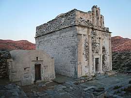 Remains of the medieval Episkopi church | |
 Sikinos Location within the region 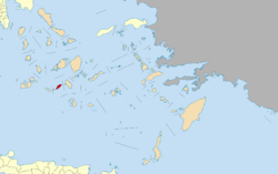 | |
| Coordinates: 36°41′N 25°7′E / 36.683°N 25.117°ECoordinates: 36°41′N 25°7′E / 36.683°N 25.117°E | |
| Country | Greece |
| Administrative region | South Aegean |
| Regional unit | Thira |
| Area | |
| • Municipality | 42.507 km2 (16.412 sq mi) |
| Highest elevation | 552 m (1,811 ft) |
| Lowest elevation | 0 m (0 ft) |
| Population (2011)[1] | |
| • Municipality | 273 |
| • Municipality density | 6.4/km2 (17/sq mi) |
| Time zone | UTC+2 (EET) |
| • Summer (DST) | UTC+3 (EEST) |
| Postal code | 840 10 |
| Area code(s) | 22860 |
| Vehicle registration | EM |
| Website | www.sikinos.gr, http://www.photosikinos.com |
Sikinos (Greek: Σίκινος) is a Greek island and municipality in the Cyclades. It is located midway between the islands of Ios and Folegandros. Sikinos is part of the Thira regional unit.[2]
It was known as Oenoe or Oinoe (Ancient Greek: Οἰνόη, Island of Wine) in Ancient Greece. It contrasts with nearby islands, such as Ios, in being quiet and relatively less developed. There are two villages, "Allopronia" on the south sea side, being the port, and another higher up in the hills being the chora. The chora up on the hills is composed of two settlements adjacent to each other, "Castro" to the west and "Chorio" to the east. There are a handful of tavernas in the harbor. The beach at the harbor is one of two large sandy beaches on the island. Several ancient ruins rest on the island, although some are remote. There are two paved roads, although a third is being built to connect the nascent heliport and eventually a new resort on the other sandy beach, and there are several well-maintained dirt roads. Much of the island is very difficult to access due to the terrain. Nearly all of the island's area is covered by terraces once used for extensive agriculture. Now only a handful are used across the island, most operating on government subsidies. The municipality had 273 inhabitants at the 2011 census. It includes the uninhabited island of Kardiotissa and other uninhabited islets. Its total land area is 42.507 square kilometres (16.412 sq mi).[3]
Anciently, the island contained a town of the same name.[4][5][6] It is said to have been originally called Oenoë from its cultivation of the vine, but to have been named Sicinos after a son of Thoas and Oenoe.[7][8][9] It was probably colonised by Ionians. Like most of the other Grecian islands, it submitted to Xerxes I in the Greco-Persian Wars,[10] but it afterwards formed part of the Athenian maritime empire. There are some remains of the ancient city situated upon a lofty and rugged mountain. There is also still extant an ancient temple of the Pythian Apollo, now converted into the church Episkopí (ἡ Ἐπισκοπή). It stands in a depression between the main range of mountairns, and the summit lying more to the left, upon which the ruins of the ancient city stand. We learn from an inscription found there by Ross that it was the temple of the Pythian Apollo.[11]
References
- ↑ "Απογραφή Πληθυσμού - Κατοικιών 2011. ΜΟΝΙΜΟΣ Πληθυσμός" (in Greek). Hellenic Statistical Authority.
- ↑ Kallikratis law Greece Ministry of Interior (in Greek)
- ↑ "Population & housing census 2001 (incl. area and average elevation)" (PDF) (in Greek). National Statistical Service of Greece.
- ↑ Periplus of Pseudo-Scylax, p. 19
- ↑ Strabo. Geographica. x. p.484. Page numbers refer to those of Isaac Casaubon's edition.
- ↑ Ptolemy. The Geography. 3.15.31.
- ↑ Stephanus of Byzantium. Ethnica. s.v.
- ↑ Xenophon. Hellenica. 1.623.
- ↑ Pliny. Naturalis Historia. 4.12.23.
- ↑ Herodotus. Histories. 8.4.
- ↑

![]()
External links
- Official website (in English) (in Greek)
| Regional unit of Andros | 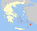 | |
|---|---|---|
| Regional unit of Kalymnos | ||
| Regional unit of Karpathos | ||
| Regional unit of Kea-Kythnos | ||
| Regional unit of Kos | ||
| Regional unit of Milos | ||
| Regional unit of Mykonos | ||
| Regional unit of Naxos | ||
| Regional unit of Paros | ||
| Regional unit of Rhodes | ||
| Regional unit of Syros | ||
| Regional unit of Thira | ||
| Regional unit of Tinos | ||