Kaş
| Kaş | |
|---|---|
| Town | |
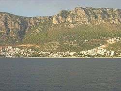 Part of the town seen from the sea | |
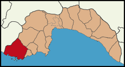 Location of Kaş within Antalya Province. | |
 Kaş Location of Kaş within Antalya Province. | |
| Coordinates: 36°12′00″N 29°38′30″E / 36.20000°N 29.64167°ECoordinates: 36°12′00″N 29°38′30″E / 36.20000°N 29.64167°E | |
| Country |
|
| Region | Mediterranean |
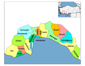
| Province | Antalya |
| Government | |
| • Mayor | Abdullah Gültekin (CHP) |
| Area[1] | |
| • District | 1,866.80 km2 (720.78 sq mi) |
| Elevation | 0- 700 m (−2,300 ft) |
| Population (2012)[2] | |
| • Urban | 7,258 |
| • District | 53,633 |
| • District density | 29/km2 (74/sq mi) |
| Time zone | UTC+2k (EETm) |
| • Summer (DST) | UTC+3 (EESTjy) |
| Postal code | 07x xx |
| Area code(s) | (0090)+ 242 |
| Licence plate | 07 |
| Website | www.kas.bel.tr |
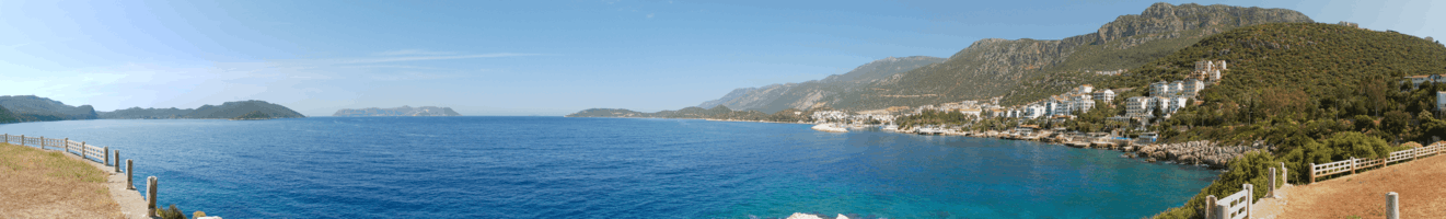
Kaş (pronounced 'Kash') is a small fishing, diving, yachting and tourist town, and a district of Antalya Province of Turkey, 168 km west of the city of Antalya. As a tourist resort, it is relatively unspoilt.
Geography
The town of Kaş is on a hill running down to the Turquoise Coast of southwestern Turkey. The district has a typical Mediterranean climate of hot, dry summers and warm, wet winters, which allows the growth of oranges, lemons and bananas. The lowland areas are also planted with cut flowers and a variety of fruits and vegetables, many are grown all year round under glass. The hillsides produce honey, and almonds, while at high altitudes there are extensive pine forests. The weather is drier at high altitudes. Although agriculture is still important, tourism is the main source of income in the district, which has many hotels and guest houses.
About 6 km (4 mi) offshore from Kaş is the Greek islet of Kastelórizo (in Turkish Meis Adası) served by a Turkish ferry daily with the option of same day returns.
Villages
- Agullu
- Ahatlı
- Aklar
- Akörü
- Bayındır
- Beldibi
- Belenli
- Belkonak
- Bezirgan
- Boğazcık
- Çamlıköy
- Çamlıova
- Çataloluk
- Çavdır
- Çayköy
- Cemre
- Çerler
- Çeşmeköy
- Çukurbağ
- Dereköy
- Dirgenler
- Doğantaş
- Gelemiş
- Gökçeören
- Gökçeyazı
- Gömbe
- Gürsu
- Hacıoğlan
- İkizce
- İslamlar
- Karadağ
- Kasaba
- Kemerköy
- Kınık
- Kızılağaç
- Ortabağ
- Ova
- Palamutköy
- Pınarbaşı
- Sahilkılıçlı
- Sarıbelen
- Sarılar
- Sinneli
- Sütleğen
- Uğrar
- Üzümlü
- Yaylakılıçlı
- Yaylapalamut
- Yeniköy
- Yeşilbarak
- Yeşilköy
- Yuvacık
History
Although the Teke peninsula has been occupied since the stone age it seems Kaş was founded by the Lycians, and its name in Lycian language was Habesos or Habesa. It was a member of the Lycian League, and its importance during this time is confirmed by the presence of one of the richest Lycian necropoleis.
In the Hellenistic period and under the Roman Empire it served as the port of Phellus. For information on its history at that time and on its archaeological remains, see the article on Antiphellus, the name by which it was known at that time.


The town suffered because of Arab incursions, then was annexed (under the name of Andifli) to the Anatolian Sultanate of Rum, led by the Seljuks. After the demise of the Seljuks, it came under the Ottomans.
In 1923, because of the Exchange of populations between Greece and Turkey after the Greco-Turkish War, the majority of the population, which was of Greek origin, left the town for Greece.[3] Abandoned Greek houses can still be seen at Kaş.[3]
In the early 1990s tourism started booming in Kaş, with visitors mainly from the UK and Germany. This growth of tourism brought an explosion in apartment building (often without license), which is seriously threatening the landscape and the environment. Particularly affected is the Çukurbağ Peninsula, west of the town, which now has luxury hotels built on it.
Tourism
The tourist industry is centred on the pleasant town of Kaş, but many other coastal towns and villages in the district have plenty of accommodation for visitors including Kalkan and Gelemiş. The district can be reached from both Antalya and Dalaman airports.
Kaş itself is a quiet pleasant town with its blue sea and narrow streets scented with jasmine flowers. There are plenty of little guest houses, quiet cafes serving home cooking, or small bars to relax after a day's scuba diving. Kaş has an annual arts festival, jazz concerts in the Hellenistic theatre and the Kiln Under the Sea arts collective have held underwater ceramics exhibitions here.
Kaş is one of the leading spots for scuba diving in Turkey. Its visited by beginners as well as advanced divers.[4] There are more than 15 dive centers and diving schools, mostly located at the local port. They offer guided diving trips to the 50 dive spots in the vicinity. Diving in Kaş offers an array of fish and other sea creatures like octopus and sea turtles. Besides the biological diversity, Kaş offers a vast variety of underwater cultural heritage. Among various wreck sites, six artificial wrecks are worth visiting. These wrecks are submerged to create artificial reefs and touristic diving spots. There are two historically important wreck sites, an airplane from World War II and a cargo ship from 1950's sink near the small islands in the extremities of Kaş. One last important diving spot is so called "Kaş Archaeopark Site" that is an experimental archaeology project conducted by Underwater Research Society (Sualtı Araştırmaları Derneği-SAD) in 2006.[5] In this scientific project, an interpretative reconstruction of the Uluburun wreck and its cargo is placed underwater.
Outdoor sport activities attract the more adventurous visitors of Kas, especially small grup holidays from Europe and independent travellers. To name a few popular adventures:
- Sea Kayaking at Kekova
- Mountainbiking the backcountry
- Trekking the Lycian Way
- Canyoning in the Kibris Canyon
On Fridays, Greek visitors from Kastelorizo visit the markets of Kaş.
Demographics
According to the 2010 census, the town has 7,041 residents and the whole district (together with the villages) has 53,135 inhabitants.[6] Kaş has 5 municipalities (Gömbe, Kalkan, Kınık, Ova and Yeşilköy) and 48 villages.
The population of inhabited places is as follows according to 2007 census (Municipalities are shown in bold)
| Town/Village | Population(2007) |
|---|---|
| Kaş | 5.922 |
| Ağıllı | 692 |
| Ahatlı | 185 |
| Aklar | 408 |
| Akörü | 356 |
| Bayındır | 653 |
| Beldibi | 314 |
| Belenli | 398 |
| Belkonak | 35 |
| Bezirgan | 1.458 |
| Boğazcık | 184 |
| Cemre | 260 |
| Çamlıköy | 280 |
| Çamlıova | 156 |
| Çataloluk | 153 |
| Çavdır | 2.482 |
| Çayköy | 1.320 |
| Çerler | 62 |
| Çeşmeköy | 185 |
| Çukurbağ | 492 |
| Dereköy | 165 |
| Dirgenler | 547 |
| Doğantaş | 484 |
| Gedikbaşı | 303 |
| Gelemiş | 713 |
| Gökçeören | 129 |
| Gökçeyazı | 872 |
| Gömbe | 1.774 |
| Hacıoğlu | 267 |
| İkizce | 180 |
| İslamlar | 2.034 |
| Kalkan | 2.259 |
| Karadağ | 1.055 |
| Kasaba | 1.168 |
| Kemerköy | 510 |
| Kılıçlı | 231 |
| Kılıçlıyayla | 272 |
| Kınık | 5.526 |
| Kızılağaç | 217 |
| Ortabağ | 257 |
| Ova | 5.126 |
| Palamut | 1.043 |
| Pınarbaşı | 112 |
| Sarıbelen | 800 |
| Sarılar | 145 |
| Sinneli | 141 |
| Sütleğen | 878 |
| Uğrar | 781 |
| Üzümlü | 1.382 |
| Yaylapalamut | 290 |
| Yeniköy | 61 |
| Yeşilbarak | 281 |
| Yeşilköy | 3.311 |
| Yuvacık | 320 |
| Total | 49.629 |
Places of interest

- The town of Kaş has a Hellenistic theatre and many other places of historical interest, as well as beaches, and a number of caves, some of them underwater.
- For scuba divers there are several spots underwater, one of them being an underwater sculpture of a shark sculpted by Kemal Tufan and another being a submerged Douglas DC-3 plane.[7]
- For sailors, a new marina with facilities for short and long stay has been opened.
- The mountains behind the coast have places for trekking, climbing and canyoning.
- The ruins of the antique cities of Komba (in the village of Gömbe), Nisa, Kandyba, Phellos, Istlada, Apollonia, Isinda and Kyaenai.
- A common excursion from Kaş is Kekova island in the neighbouring district of Demre. Here in the bays there are a number of wrecks of ancient ships and ancient cities sunk under the sea by earthquakes over the centuries. The sea is so clear that the details of city buildings such as staircases or columns can be seen from the boat. The area is also used for sea kayaking. In December 2006, Kaş was added to the specially protected Kekova marine area in order to preserve its rich biodiversity.[8]
See also
.jpg)
Sources, References
- Hazlitt, William (1851). The Classical Gazetteer: A Dictionary of Ancient geography Sacred & Profane. Whittaker, London.
References
- ↑ "Area of regions (including lakes), km²". Regional Statistics Database. Turkish Statistical Institute. 2002. Retrieved 2013-03-05.
- ↑ "Population of province/district centers and towns/villages by districts - 2012". Address Based Population Registration System (ABPRS) Database. Turkish Statistical Institute. Retrieved 2013-02-27.
- 1 2 Darke, Diana (1986). Guide to Aegean and Mediterranean Turkey. M. Haag. p. 160. ISBN 9780902743342.
The Greek ghost town of Kaya in the hills behind Fethiye is the most dramatic reminder of this exodus, but derelict Greek houses can also be seen at Kalkan, Kas and Demre.
- ↑ "10 Unique Experiences in Turkey - Tripoetic Blog". Tripoetic Blog. 2016-04-05. Retrieved 2017-02-21.
- ↑ Underwater Research Society. "Official web page".
- ↑ Statistical Institute
- ↑ http://www.express.co.uk/news/world/546994/Freedivers-underwater-WW2-plane-Kas-Turkey
- ↑ "More marine protection for Turkey's Lycian coast". World Wildlife Fund. Retrieved 2006-12-30.
External links
| Wikivoyage has a travel guide for Kaş. |