Konyaaltı
| Konyaaltı | |
|---|---|
 Konyaaltı Beaches | |
 Konyaaltı | |
| Coordinates: 36°50′20″N 30°28′52″E / 36.83889°N 30.48111°ECoordinates: 36°50′20″N 30°28′52″E / 36.83889°N 30.48111°E | |
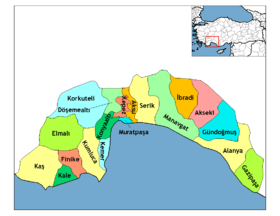
| Country | Turkey |
| Province | Antalya |
| Government | |
| • Mayor | Muhittin Böcek (CHP) |
| • Kaymakam | Bayram Yılmaz |
| Population (2012)[1] | |
| • Urban | 125,849 |
| • District | 131,513 |
| Website | www.konyaalti.bel.tr/ |
Konyaaltı is a district in the Antalya Province, Turkey. The name "Konyaaltı" (pronounced [konja.aɫtɯ]), originates from the expression of "koy altı", which in the Turkish language means "the cove down the cliffs".
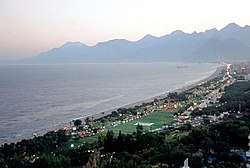
The district is situated beneath the old city of Antalya, and extends miles toward the west, with various kinds of beaches including sand and shingle. The water is a little cooler compared to other beaches in Antalya because of an underground creek flowing to the sea. There are modern underground facilities for aesthetic reasons. Transportation is easy by means of buses. Destinations are reachable by foot as well.
Market
The market works on Tuesdays. It is situated in Liman. Here is the list of some groceries available at the market:[2][3]
See also
References
- ↑ "Population of province/district centers and towns/villages by districts - 2012". Address Based Population Registration System (ABPRS) Database. Turkish Statistical Institute. Retrieved 2013-02-27.
- ↑ "Photographs of Konyaalti fruit and vegetable market in Antalya, August 2017". Independent Travellers. independent-travellers.com. Retrieved October 2, 2017.
- ↑ "Liman Market in Antalya (Konyaalti district), Turkey". YouTube. August 1, 2017. Retrieved April 16, 2018.
| Wikimedia Commons has media related to Konyaaltı. |
External links