California State Route 60
| ||||
|---|---|---|---|---|
|
Pomona Freeway Moreno Valley Freeway | ||||
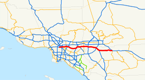 SR 60 highlighted in red | ||||
| Route information | ||||
| Defined by Streets and Highways Code § 360 | ||||
| Maintained by Caltrans | ||||
| Length | 76 mi[1] (122 km) | |||
| Existed | 1964 – present | |||
| Major junctions | ||||
| West end |
| |||
| ||||
| East end |
| |||
| Location | ||||
| Counties | Los Angeles, San Bernardino, Riverside | |||
| Highway system | ||||
| ||||

State Route 60 (SR 60) is an east-west state highway in the U.S. state of California. It runs from the East Los Angeles Interchange near downtown Los Angeles to an interchange with Interstate 10 (I-10) in Beaumont. The highway serves the cities and communities on the eastern side of the Los Angeles metropolitan area and runs along the south side of the San Gabriel Valley. The highway provides a route across several spurs of the Peninsular Ranges, linking the Los Angeles Basin with the Pomona Valley and San Gabriel Valley. It runs from the East Los Angeles Interchange near the Los Angeles River in Los Angeles with Interstate 5 (I-5), Interstate 10 (I-10) and U.S. Route 101 (US 101) east to I-10 in Riverside County, with overlaps at State Route 57 and Interstate 215. The highway runs roughly parallel to Interstate 10, functioning as a bypass alternate route east-west route through the area.
Route description
SR 60 begins at the East Los Angeles Interchange near downtown Los Angeles, designated as the Pomona Freeway. The freeway heads east from the junction after splitting off from the Santa Monica Freeway (I-10) and passes through East Los Angeles, intersecting the Long Beach Freeway (I-710). Continuing east through the southern San Gabriel Valley, SR 60 passes through many cities and communities, intersecting the San Gabriel River Freeway (I-605) in the City of Industry. It proceeds to an overlap with the Orange Freeway (SR 57) in Diamond Bar, right on the edge of the San Gabriel Valley.
A short overlap carries SR 60 traffic on the same roadway as SR 57. The two routes head northeast through an arm of the San Gabriel Valley; after they split, SR 60 ascends slightly and then slopes through the Puente Hills and into the Pomona Valley. Continuing east, SR 60 intersects the Chino Valley Freeway (SR 71) in Pomona, the Ontario Freeway (I-15) in Jurupa Valley, and the Riverside Freeway (SR 91/I-215) in Riverside, California.
A short overlap carries SR 60 traffic on the same roadway as I-215. The two routes head southeast; after this, SR 60 is designated as the Moreno Valley Freeway. The freeway runs through communities further east in the Inland Empire. After passing through Moreno Valley, SR 60 runs through the rugged hill country to the east (known as the Badlands to the locals). After that, SR 60 downgrades to an expressway, and has with several at-grade interchanges with local roads. Finally, in Beaumont, SR 60 ends and merges into the Christopher Columbus Transcontinental Highway (I-10).
SR 60 traverses Los Angeles, San Bernardino, and Riverside Counties. As it passes through many of Los Angeles' east side suburbs in southern San Gabriel and Pomona Valleys, it is a major transportation corridor. For the majority of its length it is generally parallel to, and south of, the San Bernardino Freeway, Interstate 10 (I-10), and generally parallel to, and north of, the Riverside Freeway, California State Route 91. Traffic congestion is exacerbated by the rapid population growth and, therefore, residential, commercial, and industrial development in the inland communities known informally as the Inland Empire. In particular, it has become increasingly clogged of late with shipping container-laden trucks travelling from the ports of Los Angeles and Long Beach to rail yards and warehouses in the Inland Empire. As a result of the rapid development of the Inland Empire since the 1980s, the Moreno Valley Freeway now suffers from severe traffic congestion. In the mid-2000s, the northwestern section that is concurrently signed with Interstate 215 underwent significant construction to improve traffic flow, but it still suffers from heavy congestion.
The freeway is known as the Pomona Freeway from its western terminus to its junction with State Route 91 and Interstate 215 in Riverside, and the Moreno Valley Freeway east of this interchange until its eastern terminus at its junction with Interstate 10.[2] The route is part of the California Freeway and Expressway System,[3] and is part of the National Highway System,[4] a network of highways that are considered essential to the country's economy, defense, and mobility by the Federal Highway Administration.[5]
History
The route takes its number from former U.S. Route 60, which now begins near Brenda, Arizona and terminates on the east coast at Virginia Beach, Virginia. Before 1964, U.S. 60 ran from Los Angeles to the Arizona state line, where it continued its nationwide trek, often overlapping U.S. 99 and U.S. 70 along the way. The advent of Interstate 10 created a situation where, at one point, four different signed routes would run along the state-maintained highway.
In 1964, California implemented a plan to simplify its highway-numbering system, where one state highway had only one route number and concurrencies were sternly discouraged. As a result, the U.S. 60 designation (along with U.S. 70 and U.S. 99) was removed. Interstate 10 (as Route 10) superseded U.S. 60's alignment from Beaumont and towards the Arizona state line, even though the routing was only partly a freeway. This left the officially designated Route 60 from Beaumont to Los Angeles orphaned from its original U.S. Highway (which to this day begins at a point on Interstate 10 east of Quartzsite, Arizona). This new Route 60 was provisionally signed as a U.S. Highway since the designation would guide motorists from Los Angeles to Arizona in the absence of a completed freeway for Interstate 10; when all of Route 10 was upgraded to a freeway, the U.S. Highway designation disappeared.
At least one California highway sign managed to be overlooked for many years afterward. A sign on Hess Boulevard at California State Route 62 in the unincorporated town of Morongo Valley pointing not to Interstate 10 but to U.S. 60 (with evidence of the sign having pointed to both U.S. 70 and U.S. 99 as well) stood through the early 2000s. It has since been removed.[6]
The stretch of Route 60 along the Moreno Valley Freeway made national headlines in April 2004, when five-year-old Ruby Bustamante of Indio and her 26-year-old mother, Norma, were reported missing. Their car had left the road, apparently unwitnessed, between the gap in two guard rails on April 4. It then crashed underneath a tree in a deep ravine. Though Mrs. Bustamante lost her life, presumably at the moment of impact, Ruby survived on her own for ten days on cups of uncooked Top Ramen noodles and bottles of Gatorade which were in the car.[7][8][9]
In 1998, the HOV lanes between SR 57 and I-15 opened.[10] In 2005, construction of an HOV lane started between I-605 and Redlands Boulevard in two phases.[11] The construction was finished in 2010 from I-605 to SR 57, and in 2008 from I-15 to Redlands Boulevard. The Grand Avenue (exit 24B) interchange went through some major construction during this period as well, which included adding a direct HOV connector to SR 57 and an alternate route for SR 60 west to exit Brea Canyon Road (exit 23). There are no plans to construct the HOV lanes from I-605 to the East Los Angeles Interchange or from Redlands Boulevard to Interstate 10 at this time.
On December 14, 2011, a tanker truck carrying 8,800 gallons of gasoline caught fire and exploded on the Pomona Freeway in Montebello, causing Caltrans to have to rebuild the Paramount Boulevard overpass.[12][13] Shortly after the rebuilding of the bridge, Caltrans did widening work on Paramount Boulevard's exit and entrance ramps to accommodate the new bridge and installed new traffic signals. There is also a new connection to the new Monterey Park Market Place via Neil Armstrong Street, a joint venture between the cities of Monterey Park and Montebello, which can be accessed through Paramount Boulevard.
In mid-2016, Caltrans started to construct a partial interchange at Lemon Avenue (to Brea Canyon Road) with no westbound exit. The project will finish in the summer of 2018. On May 1, 2018, the Lemon Avenue eastbound off-ramp exit and westbound on-ramp were opened. The eastbound on-ramp is still under construction. Also, on May 1, 2018, the eastbound off-ramp exit on Brea Canyon Road was removed.[14]
Future
Diamond Bar
The construction of the eastbound on-ramp that provides access to SR 60 from Lemon Avenue has yet to be complete. Once this on-ramp opens, the Brea Canyon Road eastbound on-ramp will be modified to only include access to SR 57.[15]
Another major project will reconstruct the interchange and rebuild the bridge with Grand Avenue on the east to ease bottleneck conditions with the merging of SR 57 north.[16] On the west, the exit ramps are being rebuilt. The eastern portion will begin in 2020. This interchange went through major construction in 2007, but the construction did not make any improvements to the exit ramps.
Moreno Valley to Beaumont
In order to increase safety through the Badlands corridor between Moreno Valley and Beaumont, the Riverside County Transportation Commission (RCTC) is partnering with Caltrans to complete a $138 million project to add a truck climbing lane in each direction between Gilman Springs Road and Jack Rabbit Trail. Construction is expected to begin in summer 2019.[17]
There are plans to convert SR 60 from the Jack Rabbit trail exit to its eastern terminus (I-10) to a full freeway. These plans are only in the environmental phase and have not been approved by Caltrans to begin construction.
A groundbreaking ceremony was held for the future Potrero Boulevard interchange near the Jack Rabbit Trail exit of SR 60 on February 1, 2018. It is planned to be Exit 75.[18][19]
Exit list
Except where prefixed with a letter, postmiles were measured on the road as it was in 1964, based on the alignment that existed at the time, and do not necessarily reflect current mileage. R reflects a realignment in the route since then, M indicates a second realignment, L refers an overlap due to a correction or change, and T indicates postmiles classified as temporary (for a full list of prefixes, see the list of postmile definitions).[20] Segments that remain unconstructed or have been relinquished to local control may be omitted. The numbers reset at county lines; the start and end postmiles in each county are given in the county column.
| County | Location | Postmile [20][1][21] | Exit [22][23] | Destinations | Notes |
|---|---|---|---|---|---|
| Los Angeles LA 0.00-R30.46 | Los Angeles | 0.00 | 1A | Westbound exit and eastbound entrance; west end of SR 60/Pomona Freeway; I-10 east exit 16B | |
| 0.04 | 1B | Santa Fe Avenue, Mateo Street | Westbound exit and eastbound entrance | ||
| R0.55 | 1A | Eastbound exit only; I-5 north exit 134 goes directly to I-10 west | |||
| 0.38– R0.55 | 1C | Westbound exit and eastbound entrance | |||
| R0.55 | 1E | Westbound exit and eastbound entrance; I-5 south exit 134A | |||
| R1.48 | 1D | Whittier Boulevard, Lorena Street | Signed as exit 1B eastbound; Whittier Boulevard was former US 101 | ||
| R1.94 | 2 | Indiana Street | Westbound exit and eastbound entrance | ||
| R2.59 | 3A | Downey Road | |||
| R3.27 | 3B | I-710 north exit 20A, south exit 20B | |||
| Monterey Park | R4.43 | 4 | Atlantic Boulevard | ||
| Monterey Park–Montebello line | R5.16 | 6A | Findlay Avenue | Eastbound exit and westbound entrance | |
| R5.89 | 6B | Garfield Avenue, Wilcox Avenue | Signed as exit 6 westbound | ||
| Montebello | R7.77 | 8 | Paramount Boulevard – Montebello | ||
| Rosemead | R8.55 | 9 | San Gabriel Boulevard – Rosemead | ||
| South El Monte | 9.51 | 10A | |||
| 10.23 | 10B | Santa Anita Avenue – South El Monte | |||
| 11.01 | 11 | Peck Road | |||
| Industry | 11.71 | 12 | I-605 exit 19; No control cities listed on route | ||
| 12.63 | 13 | Crossroads Parkway | |||
| Hacienda Heights | 14.26 | 14 | Seventh Avenue – Industry | Signed as exits 14A (south) and 14B (north) eastbound | |
| 15.93 | 16 | Hacienda Boulevard | Former SR 39 | ||
| Industry–Hacienda Heights line | 17.97 | 18 | Azusa Avenue (CR N8) | Proposed route of future SR 39 | |
| Rowland Heights–Industry line | 19.46 | 19 | Fullerton Road | ||
| 20.43 | 20 | Nogales Street | |||
| R21.48 | 21 | Fairway Drive – Walnut | |||
| Diamond Bar | 22.39 | 22 | Lemon Avenue to Brea Canyon Road | No westbound exit; eastbound exit and westbound entrance opened on May 1, 2018; eastbound entrance is still under construction.[24][25][26] | |
| R22.97 | 23 | Brea Canyon Road | Westbound exit was removed in 2006; A new entrance was constructed via SR 60 alternate west in 2007; eastbound exit was removed on May 1, 2018 | ||
| Diamond Bar–Industry line | R23.56 | 24A | West end of SR 57 overlap; SR 57 north exit 16 | ||
| | — | HOV access only; westbound exit and eastbound entrance | |||
| R24.45 | 24B | Grand Avenue – Diamond Bar | |||
| Diamond Bar | R25.46 | 25 | East end of SR 57 overlap; eastbound exit and westbound entrance; westbound to northbound access is via exit 26 | ||
| R25.56 | 26 | Diamond Bar Boulevard | |||
| Pomona | R28.04 | 28 | Phillips Ranch Road | ||
| R29.39 | 29A | Signed as exit 29B westbound; eastbound exit to SR 71 north is via exit 29B; SR 71 north exits 12A-B, south exits 12-13 | |||
| R29.39 | 29B | Garey Avenue | Signed as exit 29A westbound | ||
| R30.33 | 30 | Reservoir Street | |||
| San Bernardino SBD R0.00-R9.96 | Chino | R1.37 | 32 | Ramona Avenue | |
| R2.37 | 33 | Central Avenue | |||
| R3.60 | 34 | Mountain Avenue | |||
| Ontario | R4.58 | 35 | |||
| R5.86 | 36 | ||||
| R6.86 | 37 | Vineyard Avenue | |||
| R7.87 | 38 | Archibald Avenue | |||
| R8.91 | 39 | ||||
| San Bernardino–Riverside county line | R9.96 | 40 | Milliken Avenue, Hamner Avenue | Signed as exit 41A westbound; former SR 31 | |
| Riverside RIV R0.00-30.50 | Eastvale–Jurupa Valley line | R0.49 | 41 | Signed as exit 41B westbound; I-15 south exit 106, north exits 106A-B | |
| Jurupa Valley | R1.99 | 42 | Van Buren Boulevard, Etiwanda Avenue, Mission Boulevard | ||
| R3.03 | 43 | Country Village Road, Mission Boulevard | |||
| R4.55 | 45 | Pedley Road | |||
| R5.58 | 46 | Pyrite Street | |||
| 7.53 | 48 | Valley Way, Mission Boulevard – Rubidoux | |||
| 9.56 | 50 | Rubidoux Boulevard – Rubidoux | |||
| Riverside | 11.07 | 52A | Market Street – Downtown Riverside | ||
| 11.73 | 52B | Main Street | former US 91 / US 395 | ||
| R12.06 | 53A | Signed as exit 34B westbound; former US 91 south; east end of Pomona Freeway; SR 91 exits 65B-C | |||
| R12.21 43.27[N 1] | 53B | West end of I-215 overlap; no exit number westbound; former I-15E north / US 91 north / US 395 north; I-215 exit 34C | |||
| 42.84[N 1] | 34A[N 2] | Spruce Street | Closed[27] | ||
| 42.16[N 1] | 33[N 2] | 3rd Street, Blaine Street | |||
| 41.49[N 1] | 32[N 2] | University Avenue | former US 395 | ||
| 40.98[N 1] | 31[N 2] | Martin Luther King Boulevard | |||
| 40.28[N 1] | 31[N 2] | El Cerrito Drive | Closed[27] | ||
| 39.48[N 1] | 30B[N 2] | Watkins Drive, Central Avenue | |||
| R38.92[N 1] | 30A[N 2] | Fair Isle Drive – Box Springs | Westbound exit from SR 60 before merging with I-215 north; No access from I-215 north. | ||
| R38.34[N 1] R12.21 | 58 | East end of I-215 overlap; former I-15E south / US 395 south; I-215 exit 29 | |||
| Riverside–Moreno Valley line | 13.31 | 59 | Day Street | ||
| Moreno Valley | 14.32 | 60 | Frederick Street, Pigeon Pass Road | To SR 60 Business, former US 60 east | |
| 15.34 | 61 | Heacock Street | |||
| 16.35 | 62 | Perris Boulevard | |||
| 18.37 | 64 | Nason Street | |||
| 19.20 | 65 | Moreno Beach Drive | |||
| 20.37 | 66 | Redlands Boulevard – Moreno | |||
| 21.37 | 67 | Theodore Street | |||
| 22.10 | 68 | Gilman Springs Road – Hemet, San Jacinto | Former SR 177 | ||
| Beaumont | 27.98 | 74 | Jack Rabbit Trail | East end of freeway; interchange eastbound, at-grade intersection westbound; no exit number westbound | |
| | 75 | Potrero Boulevard | Future interchange[28] | ||
| | Western Knolls Avenue | At-grade intersection; west end of freeway | |||
| 30.50 | — | 6th Street – Beaumont | Eastbound exit and westbound entrance | ||
| 30.50 | East end of SR 60/Moreno Valley Freeway; I-10 exit 93 | ||||
1.000 mi = 1.609 km; 1.000 km = 0.621 mi
| |||||
See also

- Interstate 10
- U.S. Route 60
- U.S. Route 70
- U.S. Route 99
References
- 1 2 California Department of Transportation (July 2007). "Log of Bridges on State Highways". Sacramento: California Department of Transportation.
- ↑ California Department of Transportation; California State Transportation Agency (January 2015). 2014 Named Freeways, Highways, Structures and Other Appurtenances in California. Sacramento: California Department of Transportation. p. 48. Archived from the original (PDF) on May 30, 2015. Retrieved May 30, 2015.
- ↑ California State Legislature. "Section 250–257". Streets and Highways Code. Sacramento: California State Legislature. Retrieved June 9, 2017.
- ↑ Federal Highway Administration (March 25, 2015). National Highway System: Los Angeles, CA (PDF) (Map). Scale not given. Washington, DC: Federal Highway Administration. Retrieved October 14, 2017.
Federal Highway Administration (March 25, 2015). National Highway System: Riverside–San Bernardino, CA (PDF) (Map). Scale not given. Washington, DC: Federal Highway Administration. Retrieved October 14, 2017. - ↑ Natzke, Stefan; Neathery, Mike & Adderly, Kevin (June 20, 2012). "What is the National Highway System?". National Highway System. Washington, DC: Federal Highway Administration. Retrieved July 1, 2012.
- ↑ Link to California 62 article at Westcoastroads. November 2000 photo of the Morongo Valley U.S. 60 sign on Hess Boulevard is near the bottom of the page
- ↑ Pugmire, Lance; Sahagun, Louis (April 14, 2004). "Girl Survives 10 Days After Crash Killed Mom Child is found with woman's body and car near bottom of canyon". Los Angeles Times.
- ↑ Hutchinson, Bill (April 15, 2004). "How Miracle Girl Survived". The New York Daily News.
- ↑ Madigan, Nick (April 15, 2004). "5-Year-Old's Survival Tale of 10 Days Alone, Her Mother Dead". The New York Times.
- ↑ SR 57/SR 60 Improvement plan
- ↑ "11 miles of carpool lanes on the 60 Freeway formally open Thursday". October 14, 2010.
- ↑ "Tanker fire: Westbound 60 freeway now open, official says". Los Angeles Times. December 17, 2011.
- ↑ Lloyd, Jonathan; Guinyard, Toni; Murphy, Sean. "Bridge to Be Demolished After Tanker Fire". KNSD.
- ↑ Lemon Avenue interchange opens
- ↑ The ACE Project Lemon Avenue/Brea Canyon Road project description
- ↑ "SR-57 / SR-60 Confluence at Grand Avenue Project - Diamond Bar, CA". www.diamondbarca.gov.
- ↑ "RCTC Receives Funding for Truck Lanes on State Route 60". RCTC. August 16, 2018.
- ↑ "Beaumont Breaks Ground On Potrero Interchange". February 2, 2018.
- ↑ https://www.recordgazette.net/groundbreaking-held-for-new-six-lane-bridge-at-potrero-interchange/article_2173e888-0cef-11e8-b752-7364cf7ed339.html
- 1 2 California Department of Transportation. "State Truck Route List". Sacramento: California Department of Transportation. Archived from the original (XLS file) on June 30, 2015. Retrieved June 30, 2015.
- ↑ California Department of Transportation, All Traffic Volumes on CSHS, 2005 and 2006
- ↑ California Department of Transportation, California Numbered Exit Uniform System, State Route 60 Freeway Interchanges, Retrieved on 2009-02-05.
- ↑ California Department of Transportation, California Numbered Exit Uniform System, Interstate 215 Freeway Interchanges Northbound and Interstate 215 Freeway Interchanges Southbound, Retrieved on 2009-02-05.
- ↑ "Lemon Avenue / SR-60 Interchange". City of Diamond Bar. City of Diamond Bar. Retrieved February 20, 2016.
- ↑ "State Route 60/Lemon Avenue Interchange" (PDF). Caltrans. January 2008. p. vii. Retrieved February 20, 2016.
- ↑ "Lemon Avenue westbound onramp and eastbound off and onramp opening opening and Brea Canyon Road eastbound offramp closing". City of Diamond Bar. 2018.
- 1 2 "Caltrans District 8: 60-91-215 Interchange Project".
- ↑ https://patch.com/california/banning-beaumont/beaumont-breaks-ground-potrero-interchange
External links
Route map:
| Wikimedia Commons has media related to California State Route 60. |