Juazeiro
| Juazeiro | |||
|---|---|---|---|
| City | |||
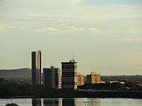 Juazeiro skyline seen from São Francisco river | |||
| |||
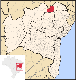 | |||
 Juazeiro Location in Brazil | |||
| Coordinates: 09°25′50″S 40°30′10″W / 9.43056°S 40.50278°WCoordinates: 09°25′50″S 40°30′10″W / 9.43056°S 40.50278°W | |||
| Country |
| ||
| Region | Northeast | ||
| State | Bahia | ||
| Mesoregion | Vale São-Franciscano da Bahia | ||
| Microregion | Juazeiro | ||
| Founded | May 9th, 1833 | ||
| Government | |||
| • Mayor | Isaac Cavalcante de Carvalho | ||
| Area[1] | |||
| • Total | 2,509,860 sq mi (6,500,520 km2) | ||
| Elevation | 3,600 ft (1,100 m) | ||
| Population (2010)[2] | |||
| • Total | 221,773 | ||
| Time zone | UTC-3 (BRT) | ||
| HDI (2010)[3] | 0.677 | ||
| Website | Official Website | ||


Juazeiro, formerly also known as Joazeiro,[4] is a municipality in the state of Bahia, in the northeastern region of Brazil. Its name comes from the juazeiro tree which grows in the region. The city is twinned with Petrolina, in the state of Pernambuco. The two cities are connected by a modern bridge crossing the São Francisco River. Together they form the metropolitan region of Petrolina-Juazeiro, an urban conglomerate of close to 500,000 inhabitants.
History
Organization
Its city districts are Abóbora, Carnaíba, Itamotinga, Junco, Juremal, Massaroca, and Pinhões.
Climate
The annual average temperature is 24.2 °C. Although it lies on the São Francisco River and the Curaçá River, the climate of the city is semi-arid and it gets an annual precipitation of only 399 mm (15.7 in.).
Transport
There are highway connections with several capitals of the Northeast and railroad connections to the coast are made by the Ferrovia Centro-Atlântica. The railroad connection ends at the fluvial port of Juazeiro.
Economy
Like its sister city Petrolina, Juazeiro has experienced great growth in the last decade due to the irrigation of the semi-arid soils with water from the São Francisco River. Fruit cultivation is important to such an extent that Juazeiro entitles itself "Capital of Irrigated Fruit", which is exported between the Petrolina Airport to USA and/or Europe. For more detailed information on the development of this fertile valley see the article on Petrolina.
Main agricultural products in planted area (2003):
- bananas: 18 km²
- coconut: 2.72 km²
- guava: 2.5 km²
- lemon: 2 km²
- papaya: 0.45 km²
- mango: 60 km²
- passion fruit: 0.9 km²
- grapes: 21 km²
- sugarcane: 152.53 km²
- onions: 3.4 km²
- beans: 4.04 km²
- manioc: 4.2 km²
- watermelon: 4.5 km²
- melon: 1.95 km²
- tomato: 0.32 km²
Data is from IBGE
Notable people
Juazeiro is the birthplace of the following famous people:
- Dani Alves: right back footballer of Paris Saint-Germain and Brazilian national team
- João Gilberto: precursor of the bossa nova movement and guitarist/songwriter
- Ivete Sangalo, the Latin Grammy Award-winning Brazilian singer
See also
References
- ↑ "Área territorial oficial" [Oficial Territorial Area] (in Portuguese). Brazilian Institute of Geography and Statistics(IBGE). 2002-10-10. Retrieved 2010-12-05.
- ↑ "Censo Populacional 2010" [Census 2010] (in Portuguese). Brazilian Institute of Geography and Statistics(IBGE). 2010-11-29. Archived from the original on 2011-05-16. Retrieved 2010-12-11.
- ↑ "Ranking decrescente do IDH-M dos municípios do Brasil" (PDF) (in Portuguese). United Nations Development Programme (UNDP). 2010. Retrieved 2013-08-07.
- ↑