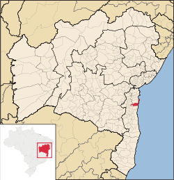
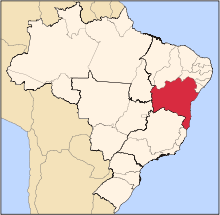
Maraú
| Maraú | ||
|---|---|---|
| Municipality | ||
 | ||
| ||
 | ||
| Country |
| |
| Region | Nordeste | |
| State | Bahia | |
| Area | ||
| • Total | 774.447 km2 (299.016 sq mi) | |
| Time zone | UTC-3 | |

Maraú is a municipality in the state of Bahia in the North-East region of Brazil.[1][2][3][4] . The municipality is located in a peninsula called "Península de Maraú", physiographic area called "Região Cacaueira" (cocoa region). The city is rich in minerals, especially oil shale gypsum and oil.
History
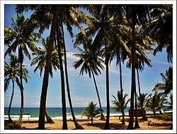
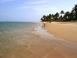
The town originally called "Mayrahú" was an Indian village called "Mayra". No one knows about the disappearance of the Indian tribe, nor to which branch it belonged. The area was discovered in 1705 by Italian Capuchin friars who named it "São Sebastião de Mayrahú" (St. Sebastian of Mayrahú). In 1938 it became a city. Maraú has beautiful beaches of rare beauty and clear water surrounds most of its villages. It also has dozens of islands, waterfalls, mangroves ... Its best-known villages are: Barra Grande, Saquaíra, Taipus de Fora and Algodões
Geography
The municipality contains 49.32% of the 118,000 hectares (290,000 acres) Baía de Camamu Environmental Protection Area, created in 2002.[5]
Beaches

- Algodões;
- Arandí;
- Barra;
- Cassange;
- Mangueira;
- Piracanga;
- Saquaíra;
- Três Coqueiros;
- Taipús de Fora;
- Campinho.
See also
References
- ↑ "Divisão Territorial do Brasil" (in Portuguese). Divisão Territorial do Brasil e Limites Territoriais, Instituto Brasileiro de Geografia e Estatística (IBGE). July 1, 2008. Retrieved December 17, 2009.
- ↑ "Estimativas da população para 1º de julho de 2009" (PDF) (in Portuguese). Estimativas de População, Instituto Brasileiro de Geografia e Estatística (IBGE). August 14, 2009. Retrieved December 17, 2009.
- ↑ "Ranking decrescente do IDH-M dos municípios do Brasil" (in Portuguese). Atlas do Desenvolvimento Humano, Programa das Nações Unidas para o Desenvolvimento (PNUD). 2000. Archived from the original on October 3, 2009. Retrieved December 17, 2009.
- ↑ "Produto Interno Bruto dos Municípios 2002-2005" (PDF) (in Portuguese). Instituto Brasileiro de Geografia e Estatística (IBGE). December 19, 2007. Archived from the original (PDF) on October 2, 2008. Retrieved December 17, 2009.
- ↑ APA da Baía de Camamu (in Portuguese), ISA: Instituto Socioambiental, retrieved 2016-10-28
Coordinates: 14°06′10″S 39°00′54″W / 14.10278°S 39.01500°W