Uibaí
| Uibaí | |
|---|---|
| Municipality | |
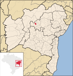 | |
 Uibaí Location in Brazil | |
| Coordinates: 11°20′13″S 42°07′58″W / 11.33694°S 42.13278°W | |
| Country |
|
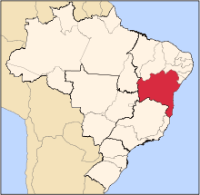
| Region | Nordeste |
| State | Bahia |
| Mesoregion | Centro Norte Baiano |
| Area | |
| • Total | 212.740 sq mi (550.994 km2) |
| Population (2010) | |
| • Total | 13,625 |
| Time zone | UTC -3 |
Uibaí is a municipality in the state of Bahia in the North-East region of Brazil. It is located about 508 kilometres (316 mi) byroad northwest of Salvador. It lies to the northeast of Gentio do Ouro and about 30 kilometres (19 mi) south-southwest of Irecê, the nearest city. Xique-Xique and the São Francisco River is to the northwest.
A rural area, population growth has been slow; in 1950 it had a population of 11,890,[1] and as of 2010 it had a population of 13,625 people.
Settlements
The municipality consists of the main town of Uibaí, the Distrito of Hidrolândia, and the settlements Quixabeira, Boca d'Aguá, Olho d’Água, Lagoinha, Laranjeiras, Zumba, Brasil, Poço, Altamira, Sobreira, Grama, Paraibinha, Caldeirão, Faz, Boa Sorte, Mandacaru, and Circuito dos Baixões.
See also
References
- ↑ Silva, Fernando Altenfelder (1961). Xique-Xique e Marrecas, duas comunidades do médio São Francisco. Comissão do Vale do São Francisco. pp. 50–51. Retrieved 12 June 2013.
Coordinates: 11°20′13″S 42°07′58″W / 11.33694°S 42.13278°W