Joint Base Andrews
| Joint Base Andrews | |
|---|---|
| Part of Air Force District of Washington (AFDW) and the United States Navy Reserve | |
| Prince George's County, Maryland, U.S. | |
 Boeing VC-25, widely known as Air Force One when the President is on board, of the 89th Airlift Wing in 2008 | |
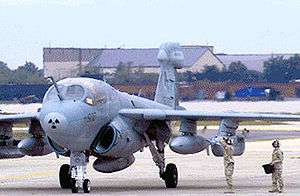 U.S. Navy EA-6B Prowler of VAQ-209 in 2008 | |
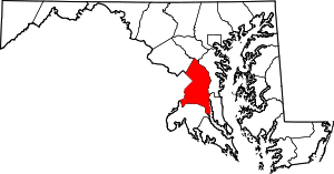
 Joint Base Andrews Location of Joint Base Andrews, Maryland | |
| Coordinates | 38°48′39″N 076°52′01″W / 38.81083°N 76.86694°WCoordinates: 38°48′39″N 076°52′01″W / 38.81083°N 76.86694°W |
| Site information | |
| Controlled by |
|
| Site history | |
| Built | 1945 |
| In use | 1945 – present |
| Garrison information | |
| Garrison |
|
| Airfield information | |||||||||||||||
|---|---|---|---|---|---|---|---|---|---|---|---|---|---|---|---|
| Summary | |||||||||||||||
| Elevation AMSL | 280 ft / 85 m | ||||||||||||||
| Website |
www | ||||||||||||||
| Runways | |||||||||||||||
| |||||||||||||||
Joint Base Andrews is a United States military facility located in Prince George's County, Maryland. The facility is under the jurisdiction of the United States Air Force 11th Wing, Air Force District of Washington (AFDW).[3] In 2009, Andrews Air Force Base and Naval Air Facility Washington were merged to form Joint Base Andrews.
The base is named for Lieutenant General Frank Maxwell Andrews (1884–1943), former Commanding General of United States Armed Forces in the European Theater of Operations during World War II. The base is widely known for serving as the home base of two Boeing VC-25 aircraft which have the call sign Air Force One while the President of the United States is on board.[4]
For statistical purposes the base is delineated as a census-designated place by the U.S. Census Bureau. As of the 2010 census, the resident population was 2,973.[5]
Overview
The host at Andrews is the 11th Wing (11 WG), assigned to the Air Force District of Washington. The 11 WG is responsible for maintaining emergency reaction rotary-wing airlift and other National Capital Region contingency response capabilities critical to national security, and for organizing, training, equipping and deploying combat-ready forces for Air and Space Expeditionary Forces (AEFs). The 11th WG commander is Colonel Bradley T. Hoagland.[6] The Command Chief Master Sergeant is Chief Master Sergeant Vance C. Kondon.[7]
Units
The following units are based at Andrews:
- 11th Wing (11 WG) (AFDW)
- The 11th Wing is responsible for maintaining emergency reaction rotary-wing airlift and other National Capital Region contingency response capabilities critical to national security, and for organizing, training, equipping and deploying combat-ready forces for Air and Space Expeditionary Forces (AEFs). The wing also provides installation security, services and airfield management to support the President, Vice President, other senior US leaders, and more than 50 tenant organizations and federal agencies.
- 89th Airlift Wing Air Mobility Command (Presidential Airlift Group)
- The 89th Airlift Wing is responsible for worldwide special air mission airlift, logistics and communications support for the President, Vice President and other senior US leaders. Air Force One is assigned to the 89th AW.
- The Air Force District of Washington (AFDW) is composed of two wings, one group and two Ceremonial Elements. The 11th Wing and the 79th Medical Wing at Joint Base Andrews. Also under AFDW is the Air Force Operations Group (AFOG) at the Pentagon and the 844th Communications Group. The Air Force Operations Group is the principal operational entity of the Air Staff in support of the Secretary of the Air Force and the Chief of Staff of the Air Force. The 79th Medical Wing and 844th Communications Group both have specialized missions where they will be the single Air Force voice in the National Capital Region (NCR) for their respective fields of expertise. The 11th Wing will fulfill duties as the host base organization of Andrews while also supporting AFDW requirements. Through the U.S. Air Force Band and the U.S. Air Force Honor Guard, the 11th Wing also provides ceremonial and musical support throughout the National Capital Region and worldwide.
- The 79th Medical Wing is the Air Force's single medical voice for planning and implementing Air Force and joint medical solutions within the National Capital Region (NCR). Activated on 10 May 2006, it is the largest wing within the Air Force District of Washington and one of only two medical wings in the Air Force.
- Tenant Units
- 457th Airlift Squadron
- 113th Wing (Air National Guard / Air Combat Command-gained and Air Mobility Command-gained)
- 459th Air Refueling Wing (Air Force Reserve Command / Air Mobility Command-gained)
- 744th Communications Squadron
- Air National Guard Readiness Center
- District of Columbia Air National Guard
- Army Jet Detachment
- Civil Air Patrol – Andrews Composite Squadron and Congressional Squadron
- Fleet Logistics Support Squadron 1 (Navy Reserve)
- Fleet Logistics Support Squadron 53 (Navy Reserve)
- National Guard Bureau
- Naval Air Facility Washington D.C.
- Naval Communications Security Material Systems
- Maryland State Police Aviation Division (Medevac Helicopter)
- Federal Aviation Administration
Aircraft assigned
- C-20B/D (89th Airlift Wing, Army Jet Detachment)
- C-21 (457th Airlift Squadron)
- C-32A (89th Airlift Wing)
- C-37A (89th Airlift Wing, Army Jet Detachment)
- C-37B (89th Airlift Wing, Army Jet Detachment and VR-1 (USNR) / Naval Air Facility)
- C-38 (113th Wing, D.C. Air National Guard)
- C-40B/C (89th Airlift Wing/113th Wing, DC Air National Guard)
- C-130 Hercules (VR-53 (USNR) / Naval Air Facility)
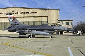
- F-16 Fighting Falcon (113th Wing, DC Air National Guard)
- KC-135R Stratotanker (459th Air Refueling Wing)
- UC-35 (Army Jet Det, and VMR Andrews (USMCR) / Naval Air Facility)
- UH-1N, (11th Wing)
- VC-25A, Air Force One (89th Airlift Wing)
- Cessna 182 (Civil Air Patrol)
History

On 1 October 2010, following the recommendations of the 2005 Base Realignment and Closure process, the Air Force completed the merger of the 11th Wing and the 316th at Joint Base Andrews. The 11th Wing became the host base organization for Joint Base Andrews.[8][9][10]
Major commands to which assigned
- Air Force District of Washington, 1 October 2009 – present
Major units assigned
- 1st Airlift Squadron 2009–present
- 459th Air Refueling Wing 2009–present
- Malcolm Grow Medical Center, 2009–present
- 89th Airlift Wing, 2009–present
- 79th Medical Wing, 2009–present
- 316th Wing, 2009-30 September 2010
- 11th Wing, 2009–present
- Air Force District of Washington, 2009–present
- Headquarters, U.S. Air Force Office of Special Investigations
Geography
Joint Base Andrews is located at 38°48′13″N 76°52′17″W / 38.80361°N 76.87139°W (38.803490, −76.871508),[11] a few miles southeast of Washington, D.C. near the town of Morningside. It is delineated as a census-designated place by the United States Census Bureau. The CDP has a total area of 6.9 square miles (18.0 km2), of which 6.9 square miles (17.9 km2) is land and 0.04 square miles (0.1 km2), or 0.51%, is water.[12]
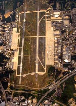
There are two runways on the base; the western runway is 11,300 feet (3,400 m) in length, and the eastern runway is 9,750 feet (2,970 m) in length. The minor third runway between them at the top of the picture (above the cross-base roadway) is now closed, and the small T-shaped runway at the bottom right of the opening picture was closed and demolished by 2008.[13]
Demographics
| Historical population | |||
|---|---|---|---|
| Census | Pop. | %± | |
| 1970 | 6,418 | — | |
| 1980 | 10,064 | 56.8% | |
| 1990 | 10,228 | 1.6% | |
| 2000 | 7,925 | −22.5% | |
| 2010 | 2,973 | −62.5% | |
| source:[5][14] | |||
As of the census[15] of 2000, there were 7,925 people, 1,932 households, and 1,864 families residing in the CDP. The population density was 1,158.9 people per square mile (447.3/km²). There were 2,133 housing units at an average density of 311.9 sq mi (120.4/km²). The racial makeup of the base was 65.3% White, 22.8% African American, 0.6% Native American, 3.2% Asian, 0.1% Pacific Islander, 3.7% from other races, and 4.4% from two or more races. Hispanic or Latino of any race were 8.7% of the population.
There were 1,932 households out of which 75.9% had children under the age of 18 living with them, 86.1% were married couples living together, 7.3% had a female householder with no husband present, and 3.5% were non-families. 3.2% of all households were made up of individuals, none of whom was 65 years of age or older. The average household size was 3.39 and the average family size was 3.44.
In the CDP, the population is spread out with 35.0% under the age of 18, 16.3% from 18 to 24, 44.9% from 25 to 44, 3.6% from 45 to 64, and 0.2% who were 65 years of age or older. The median age was 24 years. For every 100 females, there were 119.7 males. For every 100 females age 18 and over, there were 126.0 males.
The median income for a household in the base was $44,310, and the median income for a family was $42,866. Males had a median income of $27,070 versus $27,308 for females. The per capita income for the base was $16,520. About 2.6% of families and 2.4% of the population were below the poverty line, including of the total population, 2.8% of those under the age of 18 and none of those 65 and older.
Housing
The family housing, privatized, is operated and owned by Liberty Park at Andrews.[16][17]
Facilities for residents
The U.S. Postal Service operates the Andrews AFB Post Office.[18]
Joint Base Andrews CDP is served by the Prince George's County Public Schools (PGCPS).[19] Residents of the CDP are zoned to Francis T. Evans Elementary School,[20] Stephen Decatur Middle School,[21] and Dr. Henry A Wise Jr. High School.[22]
Evans Elementary, within the CDP, has a Clinton postal address and opened in 1968.[19][23] Its namesake is Captain Francis T. Evans, who died when his plane crashed in Prince George's County; according to the school's website, observed believed that he did not bail out since he did not want his aircraft to hit Forestville Elementary School.[23]
There is also a charter school, Imagine Andrews Public Charter School (IAPCS), which opened in 2010.[24] Imagine Schools operates Imagine Andrews,[25] which is a joint venture between it, PGCPS, and Joint Base Andrews. The school reserves 65% of its enrollment spaces for children of military families.[26]
Official insignia
The installation commander of Joint Base Andrews approved a logo re-design in the spring of 2014, which aimed to improve the branding and the overall appearance of the installation across all platforms. The project took several months and went through numerous design changes before approval, but was finalized in the late summer. The new JBA logo project was led and chiefly designed by Senior Airman Dan Burkhardt with important contributions by Mr. Dean Markos, who were both serving the Air Force in the 11th Wing Public Affairs office. The logo was approved and disseminated across all digital platforms and marketed locally in the fall of 2014.
The new logo was re-designed with a flatter, more modern design aesthetic that could comfortably occupy a number of different mediums, from mobile apps, to installation trucks and signs. Contained in it are a number of design elements that refer directly to the joint mission of the installation, which is home to several Air Force Major Commands, Naval Commands, a Marine detachment and a number of other military and government related units.
Design elements
- U.S. Capitol Building: The Capitol Building refers to the location of the installation (just outside Washington D.C.) and critical role it plays in supporting the operations and leadership of the U.S. Government.
- Dual Planes with Contrails: The two planes taking off with contrails flowing downward signify the aerial missions that Joint Base Andrews either hosts or supports directly every day, including the operations and maintenance of Air Force One.
- America's Airfield: This phrase (one of several unofficial tag-lines of the installation) refers to the mission-critical role that Joint Base Andrews plays in national defense, government and diplomacy.
- Joint Base Andrews Naval Air Facility Washington: Unlike the previous logo design, the new design incorporates the official name of the installation in the post-BRAC era.
See also
Notes
- ↑ Andrews Air Force Base, official site
- ↑ FAA Airport Master Record for ADW (Form 5010 PDF), effective 2007-10-25
- ↑ Officials unveil Joint Base Andrews
- ↑ Factsheets : Presidential Airlift Group (AMC) United States Air Force Archived 30 May 2013 at the Wayback Machine.
- 1 2 "Profile of General Population and Housing Characteristics: 2010 Demographic Profile Data (DP-1): Andrews AFB CDP, Maryland". U.S. Census Bureau, American Factfinder. Retrieved 15 December 2011.
- ↑ "Biographies : COLONEL BRADLEY T. HOAGLAND". Archived from the original on 16 January 2016. Retrieved 30 June 2016.
- ↑ "Biographies : CHIEF MASTER SERGEANT VANCE C. KONDON". Archived from the original on 16 January 2016. Retrieved 30 June 2016.
- ↑ "Factsheets : Joint Base Andrews History". Retrieved 30 June 2016.
- ↑ Mission, movement, manning – installation members stand at ready for 11 WG merger United States Air Force
- ↑ Slideshow: 11th Wing becomes the host wing at JBA United States Air Force
- ↑ "US Gazetteer files: 2010, 2000, and 1990". United States Census Bureau. 12 February 2011. Retrieved 2011-04-23.
- ↑ "Geographic Identifiers: 2010 Demographic Profile Data (G001): Andrews AFB CDP, Maryland". U.S. Census Bureau, American Factfinder. Retrieved 15 December 2011.
- ↑ andrews air force base – Google Maps. Maps.google.co.uk (1 January 1970). Retrieved on 2013-07-21.
- ↑ "CENSUS OF POPULATION AND HOUSING (1790–2000)". U.S. Census Bureau. Retrieved 2010-07-18.
- ↑ "American FactFinder". United States Census Bureau. Retrieved 2008-01-31.
- ↑ "Welcome to Joint Base Andrews Housing." Joint Base Andrews. Retrieved on September 2, 2018.
- ↑ Home. Liberty Park at Andrews. Retrieved on September 2, 2018. "2097 San Antonio Blvd, Joint Base Andrews , MD 20762"
- ↑ "ANDREWS AFB." U.S. Postal Service. Retrieved on September 11, 2018. "1668 D ST JB ANDREWS, MD 20762-9998"
- 1 2 "2010 CENSUS - CENSUS BLOCK MAP (INDEX): Andrews AFB CDP, MD." U.S. Census Bureau. Retrieved on September 2, 2018. Pages: 1 and 2.
- ↑ "NEIGHBORHOOD ELEMENTARY SCHOOLS AND BOUNDARIES SCHOOL YEAR 2018-2019." Prince George's County Public Schools. Retrieved on September 2, 2018.
- ↑ "NEIGHBORHOOD MIDDLE SCHOOLS AND BOUNDARIES SCHOOL YEAR 2018-2019." Prince George's County Public Schools. Retrieved on September 2, 2018.
- ↑ "NEIGHBORHOOD HIGH SCHOOLS AND BOUNDARIES SCHOOL YEAR 2018-2019." Prince George's County Public Schools. Retrieved on September 2, 2018.
- 1 2 "About Our School." Francis T. Evans Elementary School. Retrieved on September 2, 2018. "6720 Old Alexandria Ferry Road, Clinton MD, 20735"
- ↑ "Charter School." Liberty Park at Andrews. Retrieved on September 2, 2018.
- ↑ Home. Imagine Andrews Public Charter School. Retrieved on September 2, 2018. "4710 San Antonio Boulevard Andrews Air Force Base, MD 20762"
- ↑ Cardoza, Kavitha (2015-04-10). "D.C. joins push to open more charter schools for military children". Washington Post. Retrieved 2018-09-02.
Attribution

External links
| Wikimedia Commons has media related to Joint Base Andrews Naval Air Facility. |
- Joint Service Open House and Airshow at Andrews Air Force Base
- Why is it Named Andrews Air Force Base?
| Leadership |  | ||||||||||
|---|---|---|---|---|---|---|---|---|---|---|---|
| Structure |
| ||||||||||
| Personnel and training | |||||||||||
| Uniforms and equipment | |||||||||||
| History and traditions |
| ||||||||||
| |||||||||||
.svg.png)