Jimboomba
| Jimboomba Logan City, Queensland | |||||||||||||||
|---|---|---|---|---|---|---|---|---|---|---|---|---|---|---|---|
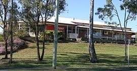 The post office and veterinary surgery, Jimboomba. | |||||||||||||||
 Jimboomba | |||||||||||||||
| Coordinates | 27°50′S 153°02′E / 27.833°S 153.033°ECoordinates: 27°50′S 153°02′E / 27.833°S 153.033°E | ||||||||||||||
| Population | 13,201 (2016 census)[1] | ||||||||||||||
| Established | 1845 | ||||||||||||||
| Postcode(s) | 4280 | ||||||||||||||
| Location | 41 km (25 mi) south of Brisbane CBD | ||||||||||||||
| LGA(s) | Logan City | ||||||||||||||
| State electorate(s) | Logan | ||||||||||||||
| Federal Division(s) | Wright | ||||||||||||||
| |||||||||||||||
Jimboomba is a growing town and locality in Logan City, Queensland, Australia.[2][3] In the 2016 census, Jimboomba had a population of 13,201 people.[1]
History
The original spelling was Gimboomba, named after a sheep and livestock station based where the township is today, stretching some distance north, east and south to neighbouring areas. Gimboomba is a Gugingin word (the First Australian peoples of the area, of Yugambeh country) meaning place of loud thunder and little rain. A culture trail celebrating First Australian culture is based at a local primary school bearing the name 'Loud Thunder' paying respect to its traditional owners.
Jimboomba Provisional School opened on 12 May 1890, becoming Jimboomba State School on 1 June 1900.[4][5]
Jimboomba was serviced by the Beaudesert railway line that was established to service the abattoir in Beaudesert. The line was closed in 1995 and then reopened and operated as a tourist service as far as Logan Village by railway enthusiasts from 1999 until mid-2004. Funds were harder to raise and depleted quickly for the line so it was closed permanently.[6]
Formerly in the Shire of Beaudesert, Jimboomba became part of Logan City following the local government amalgamations in March 2008.
On 29 September 2017, areas in the east of the locality were excised to create the new localities of Glenlogan and Riverbend and to allow for the expansion of the boundaries of Flagstone and South Maclean.[3]
Geography
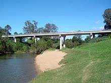
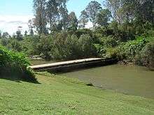
Jimboomba is situated on the Mount Lindesay Highway, 47 kilometres (29 mi) south of Brisbane central business district. The eastern and western parts of Jimboomba are divided by the Logan River; the only bridge within the locality is Payne Bridge on Cusack Lane (27°49′14″S 153°00′15″E / 27.82068°S 153.00428°E). There is a low-level older bridge immediately to the north of Payne Bridge but this cannot be used by vehicular traffic.
The Queensland government's current plan is that Jimboomba will become a major residential area. The Flagstone housing estate at Jimboomba sometimes gets confused with the townships of Flagstone Creek and Upper Flagstone which are decades-old towns in the Lockyer Valley Region.
Economy
Cattle grazing, dairy farming and hobby farms are the historical industries. However, Jimboomba now has a growing industrial area that provides services for vehicles, irrigation and home-water supplies, produce supplies, light manufacturing and landscape gardening.
Facilities
It has a large number of services, including an auxiliary/rural fire brigade and permanent ambulance service, a police station, a State Emergency Services depot, domestic shopping, hotel, and medical-dental services.
The Logan City Council operate a public library at 18 - 22 Honora Street.[7]
Education
There are five schools in Jimboomba:[8]
- Jimboomba State School, a government primary school (P-6), located on the Mount Lindesday Highway [9] (27°49′48″S 153°01′36″E / 27.8299°S 153.0268°E)
- Flagstone State School, a government primary school (P-6), located on Poinciana Drive [10] 27°48′26″S 152°57′27″E / 27.8072°S 152.9574°E)
- Flagstone State Community College, a government secondary school (7-12), located at corner of Homestead and Poinciana Drives [11](27°48′26″S 152°57′22″E / 27.807107°S 152.956215°E)
- Emmaus College, a private Eccumenical primary and secondary school (P-12), located at 48 East Street [12] (27°50′03″S 153°02′15″E / 27.8343°S 153.0376°E)
- Hills International School, a private primary and secondary school (P-12), located at Johanna Street (27°49′01″S 153°01′08″E / 27.8170°S 153.0190°E)
- South Queensland Academy (SQA), a Japanese international school, was formerly located in Jimboomba.[13]
Urban development
Jimboomba's Flagstone housing estate is expected to expand west over the railway line into Undullah and north into South Maclean, New Beith and Greenbank. This is known as the Greater Flagstone development area. The total area encompassed by the project is 7,188 hectares.[14] Final approval for the project was granted in October 2011.[15]
The expected population for this housing area is to exceed 120,000 people.[14] A new office and shopping precinct is planned to be built next to the railway line in Undullah next to the proposed Undullah railway station.
Demographics
In the 2016 census, Jimboomba recorded a population of 13,201 people, 49.4% female and 50.6% male.[1]
The median age of the Jimboomba population was 34 years, 4 years below the national median of 38.[1]
78.75% of people living in Jimboomba were born in Australia. The other top responses for country of birth were New Zealand 5.2%, England 4.8%, Scotland 0.6%, South Africa 0.6%, Scotland 0.5%, Netherlands 0.4%.[1]
91% of people spoke only English at home; the next most common languages were 0.5% Hmong, 0.3% Cantonese, 0.2% Dutch, 0.2% German, 0.2% Japanese.[1]
Sport and recreation
A number of well-known sporting teams represent the local area, including the Jimboomba Thunder, the rugby league club that plays home games at Jimboomba Park and the Jimboomba Redbacks AFL club that plays home games at Glenlogan Park
There are large numbers of horses kept on or near residential properties for riding, for pleasure and for competition.
Jimboomba is home to the Jimboomba X Stadium, Jimboomba's own extreme sports outdoor venue. Holding events such events as 2014 QLD Supercross Championship, 2015 QLD Stadium X Series & two rounds of the 2015 Australian Supercross Championship, Jimboomba X Stadium is located at Hills International College grounds. The opening round of the 2016 Australian Supercross Championship is set to be held at the Jimboomba X Stadium on September 17
In popular culture
In Civilization: Beyond Earth, "Jimboomba" is the default name for the second colony established by the Polystralian faction.
References
- 1 2 3 4 5 6 Australian Bureau of Statistics (27 June 2017). "Jimboomba (State Suburb)". 2016 Census QuickStats. Retrieved 2 September 2017.

- ↑ "Jimboomba - town in Logan City (entry 17200)". Queensland Place Names. Queensland Government. Retrieved 26 October 2017.
- 1 2 "Jimboomba - locality in Logan City (entry 50114)". Queensland Place Names. Queensland Government. Retrieved 26 October 2017.
- ↑ "Opening and closing dates of Queensland Schools". Queensland Government. Retrieved 13 May 2014.
- ↑ "Agency ID5355, Jimboomba State School". Queensland State Archives. Retrieved 13 May 2014.
- ↑ Jason Koutsoukis (17 February 2005). "PM admits rail line was not viable". The Age. The Age Company Ltd. Retrieved 28 June 2011.
- ↑ "Jimboomba Library". Logan City Council. Retrieved 30 January 2018.
- ↑ "Queensland State and Non-State Schools". Queensland Government. Retrieved 13 May 2014.
- ↑ "Jimboomba SS". Retrieved 29 January 2017.
- ↑ "Flagstone SS". Retrieved 29 January 2017.
- ↑ "Flagstone SCC". Retrieved 29 January 2017.
- ↑ "Emmaus College". Retrieved 29 January 2017.
- ↑ "私立在外教育施設一覧" (). Ministry of Education, Culture, Sports, Science and Technology. August 9, 2004. Retrieved on April 6, 2015. "サウスクイーンズランドアカデミー LOT4 JOHANNA ST.JIMBOOMBA,QUEENSLAND 4280 AUSTRALIA"
- 1 2 "Greater Flagstone". Department of State Development, Infrastructure and Planning. 21 November 2013. Archived from the original on 9 January 2014. Retrieved 5 January 2014.
- ↑ "Greater Flagstone". Logan City Council. Archived from the original on 5 January 2014. Retrieved 5 January 2014.
External links
| Wikimedia Commons has media related to Jimboomba, Queensland. |