Edens Landing, Queensland
| Edens Landing Logan City, Queensland | |||||||||||||||
|---|---|---|---|---|---|---|---|---|---|---|---|---|---|---|---|
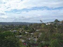 Homes along an elevated ridge with other Logan City suburbs in the background, 2014 | |||||||||||||||
| Population | 5,094 (2016 census)[1] | ||||||||||||||
| Location | 33 km (21 mi) south of Brisbane CBD | ||||||||||||||
| LGA(s) | Logan City | ||||||||||||||
| State electorate(s) | Macalister | ||||||||||||||
| Federal Division(s) | Forde | ||||||||||||||
| |||||||||||||||
Edens Landing is a residential suburb located south of Brisbane, Queensland, Australia, within the Logan City municipality. At the 2016 Australian Census, the suburb recorded a population of 5,094.[1]
History
The current suburb of Edens Landing is a recent settlement developed by Leighton Holdings. It was originally called Holmview Heights. There is a street named after the original developers, Leighton Drive. Edens Landing was established in 1984-5 when Henry Edens, a man involved in the timber industry, allowed Leighton Holdings to clear the land, this was the start of many business dealings that lead to Edens acquiring the land and beginning the residential settlement.[2]
Demographics
In the 2016 census, Edens Landing recorded a population of 5,094 people, 51.2% female and 48.8% male.[1] The median age of the Edens Landing population was 33 years, 5 years below the national median of 3, with 69.8% of people living in Edens Landing born in Australia. The other top responses for country of birth were New Zealand 8.7%, England 4.0%, Afghanistan 1.2%, Philippines 1.0%, South Africa 0.6%. 84.4% of people spoke only English at home; the next most common languages were 0.9% Samoan, 0.8% Dari, 0.6% Hazaraghi, 0.6% Filipino, 0.5% Spanish.
Education
Edens Landing State Primary School was founded in 1997 as a public government owned primary education school. Located at Jamie Nicolson Avenue, the school has an enrolment of 746 students.[3] The school has a large oval for school sporting events as well as tennis, netball and basketball courts, with a small field located in the upper region of the school.[4]
Sporting
Located off Loane Drive is Edens Landing's only sporting establishment. A rugby league club, The Edens Landing Dragons formed in 1993 operated on Leighton fields. The club offers teams from under 7's to Opens, participating in a number of competitions in Brisbane.[5]
Transportation
Edens Landing is serviced by the Logan City bus company with bus 562 making stops along the main street of Castile Crescent. This bus service connects at the Loganholme bus station and interchange (located adjacent to the Logan Hyperdome shopping centre) with a variety of bus services to the Brisbane CBD. Edens Landing also has a train station that is part of the Beenleigh railway line.[6]
Health
Edens Landing has its own medical centre and pharmacy located on Castile Crescent in the Edens Landing shop complex.[7]
Shopping
Edens Landing has a number of shops most of which are located on a small complex near leighton fields on Castile Crescent, these include, Rainbow corner child care centre, medical centre, spa general shop, pharmacy, fish & chip shop, bakery, hairdresser and an Sushi take-out store. Other shops located in Edens Landing is a real estate agent located on Leighton Drive.[8]
Religion
Currently Edens Landing has only one religious service, a Seventh-day Adventist Church.[9]
References
- 1 2 3 Australian Bureau of Statistics (27 June 2017). "Edens Landing (State Suburb)". 2016 Census QuickStats. Retrieved 3 April 2018.

- ↑
- ↑ Archived July 6, 2011, at the Wayback Machine.
- ↑ https://web.archive.org/web/20110706114410/http://edenslandingss.eq.edu.au/wcmss/index.php/home.html. Archived from the original on July 6, 2011. Retrieved November 29, 2010. Missing or empty
|title=(help) - ↑ http://www.edenslandingrlfc.org.au/History.htm
- ↑ Edens Landing railway station, Brisbane
- ↑ http://www.aussieweb.com.au/directory/directory.aspx?cid=4027&lid=26615
- ↑ Archived August 2, 2008, at the Wayback Machine.
- ↑ http://edenslanding.adventist.org.au/index.php?option=com_na_content&task=view&id=3&Itemid=7
External links
| Wikimedia Commons has media related to Edens Landing, Queensland. |
Coordinates: 27°42′17″S 153°10′8″E / 27.70472°S 153.16889°E