Browns Plains, Queensland
| Browns Plains Logan City, Queensland | |||||||||||||||
|---|---|---|---|---|---|---|---|---|---|---|---|---|---|---|---|
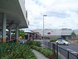 Grand Plaza Shopping Centre, 2014 | |||||||||||||||
| Population | 6,309 (2016 census)[1] | ||||||||||||||
| Postcode(s) | 4118 | ||||||||||||||
| Location | 24 km (15 mi) from Brisbane GPO | ||||||||||||||
| LGA(s) | Logan City | ||||||||||||||
| State electorate(s) | |||||||||||||||
| Federal Division(s) | Rankin | ||||||||||||||
| |||||||||||||||
Browns Plains is a suburb of Logan City, Queensland, Australia.[2] At the 2016 Australian Census the suburb recorded a population of 6,309, a significant increase from the 5,574 recorded in 2011.[1] The area suburb's western boundary is marked by the Mount Lindesay Highway.
History

According to Mary Howells book 'Ridge To Ridge - Recollections from Woodridge to Park Ridge', Browns Plains became in use as a place name in 1840 and for the most part up until the 1950s saw the original area running with tobacco farms.
In 1872, George Stretton operated a post office from his accommodation house in Browns Plains. 1878 saw Browns Plains School open on site of Waller Park, only to close due to effects of major drought in 1902.
Greenbank and Browns Plains telephone lines were installed in 1938.
A post office and store opened in 1956, with the post office being named Brownsleigh. The following year Scrubby Creek Bridge was built over Browns Plains Road.
In 1966, Beaudesert Shire employed consultant town planner and architect James Birrell. Beaudesert Shire gazetted the old Browns Plains School site as waste treatment plant and Refuse depot (now known as Waller Park). 1968, Springwood development begins Telephone exchange to be built in Browns Plains (using the prefix 200 xxxx). Browns Plains Tavern opened in 1976.
A new post office was opened in 1980 and the name reverted to Browns Plains.[3]
1983 saw the primary school open followed by a high school in 1985.[4] Westpoint Shopping Centre opened in 1984 with Waller Park established that same year.
Logan West Library opened in 2003.[5]
Demographics
In the 2016 census, Browns Plains recorded a population of 6,309 people, 50.5% female and 49.5% male.[1] The median age of the Browns Plains population was 32 years, six years below the national median of 38. 59.8% of people living in Browns Plains were born in Australia, slightly lower than the national average of 66.7%. The other top responses for country of birth were New Zealand 9.2%, England 2.1%, Philippines 1.8%, India 1.6% and China 1.3%. 69.7% of people spoke only English at home; the next most common languages were 2.8% Mandarin, 1.5% Samoan, 1.3% Hindi and 1.2% Urdu.
Geography
Browns Plains is generally used as a name for both the Browns Plains suburb and the former estates which all utilise the 4118 Postcode Hillcrest, Forestdale, Regents Park and Heritage Park. Browns Plains has been identified in the South East Queensland Regional Plan as an outer city regional centre.
Scrubby Creek, a tributary of Slacks Creek, which is itself a tributary of the Logan River, is the main waterway in the area.
Amenities
One notable aspect of Browns Plains is the Grand Plaza Shopping Centre, which opened in 1994 and was extended 13 years later. Grand Plaza boasts 170 specialty stores, Big W, Target, Kmart, Woolworths, Coles, Aldi and an Event Cinema complex.[6] Browns Plains contains a number of schools and shops, and frequently has visits from the a circus and other events on a main park area near Browns Plains Highschool and Forest Glen Park.
The Logan City Council operate the Logan West public library at 69 Grand Plaza Drive.[7]
Transport
Browns Plains is also a terminus for Brisbane city bus routes, making it an important transport hub connecting Logan city and Brisbane city bus routes.
References
- 1 2 3 Australian Bureau of Statistics (27 June 2017). "Browns Plains (Qld)". 2016 Census QuickStats. Retrieved 29 December 2017.

- ↑ "Browns Plains (entry 47118)". Queensland Place Names. Queensland Government. Retrieved 9 May 2014.
- ↑ "Browns Plains" (PDF). Logan City Council Libraries.
- ↑ "Opening and closing dates of Queensland schools (B)". education.qld.gov.au. Retrieved 2018-01-19.
- ↑ "Public Libraries Statistical Bulletin 2016-17" (PDF). Public Libraries Connect. State Library of Queensland. November 2017. p. 14. Archived (PDF) from the original on 30 January 2018. Retrieved 30 January 2018.
- ↑ Grand Plaza website. Retrieved on 13 September 2012.
- ↑ "Logan West Library". Logan City Council. Retrieved 30 January 2018.
External links
| Wikimedia Commons has media related to Browns Plains, Queensland. |