India–Myanmar barrier
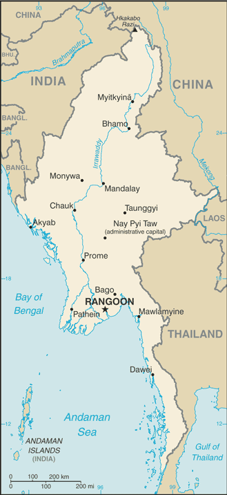
The India–Myanmar barrier is a border barrier that India is constructing to seal its 1,624-kilometre (1,009 mi)-long border with Myanmar. India hopes to curtail cross-border crime, including goods, arms and counterfeit currency smuggling, drug trafficking and insurgency. The United Nations Drug Control Programme (UNDCP) and International Narcotics Control Board (INCB) also warned that the region could become a major transit point for illicit drugs because of the poor state of border security facilities.[1] Indian security forces blamed the porous border for the deaths of 200 security personnel and civilians in militancy-related violence in the region in 2001-2003.[2] Four Northeast Indian states share the border with Myanmar: Arunachal Pradesh, Nagaland, Mizoram and Manipur. Both national governments agreed to conduct a joint survey before erecting the fence. The Indian Home Ministry and its Myanmar counterpart completed the survey within six months and in March 2003 began erecting a fence along the border.[3]
Local protests
In 2004, fencing work in the state of Manipur along the border was stalled due to protests raised by the local Kuki and Naga communities. According to them, a huge stretch of land would become Myanmar's territory and foster unrest among people living on both sides of the border. The protests from people living in the Moreh, Chorokhunou and Molchan areas forced the Home Ministry to refer the matter to the Manipur government.[3] This fence will divide many ethnic communities, including the Lushei, Nagas, Chins and Kukis whose lands straddle the regions between the two states. It is thus a highly sensitive issue.[1]In 2007 it was reported that in the state of Manipur, a boundary dispute arose with ownership of nine border pillars being disputed.[4]
Indo-Myanmar Border Force
Indo-Myanmar Border Force (IMBF) is a proposed and soon-to-be-composed force of 29 battalions, 25 battalions from Assam Rifles and 4 battalions from Indo-Tibetan Border Police, to guard 1,643-km long Indo-Myanmar border. IMBF will remain under ITBP and will patrol the border to the zero line (c. Jan 2018).[5]
International border crossings
Designated immigration and customs crossings
Officially designated immigration and customs posts and their map:
- Moreh, India to Tamu, Myanmar in Manipur
- Zorinpui International border crossing in Mizoram.[6]
Other local border crossings
Map of major border customs checkposts
The India–Myanmar border has the Free Movement Regime (FMR) which allows the tribes living along the border to travel 16-km across the boundary without visa restrictions.[7] There are over 250 villages with over 300,000 people living within 10 km of the border who frequently cross the border through 150 small and large, formal and informal, border crossings.[8]
Arunachal Pradesh State
- Diphu Pass to Mayanmar in Arunachal Pradesh is closer to China–Myanmar–India border
- Nampong to Pangsau Pass near Lake of No Return on Mayanmarese side, via National Highway 153 (India) (Ledo Road which is part of Stilwell Road)
Manipur State
- Behiang to Khenman via Tedim Road[9]
- Moreh, India to Tamu, Myanmar, has an integrated immigration check post with customs
Mizoram State
- Zorinpui International border crossing, on Indo-Myanmar border on Kaladan Multi-Modal Transit Transport Project, is 287 km away from Sittwe Port and 90 km from Aizawl-Saiha National Highway (National Highway 54 (India) (NH-54)) at Lawngtlai in Mizoram. NH-54 continues further to Dabaka in Assam via 850 km long NH-54. NH-54 is part of the larger East-West Corridor connecting North East India with the rest of India.[10] Almost complete (June 2017).[11] It is a designated customs and immigration post, open to all categories of international travelers with valid travel document and visa.[6]
- Zokhawthar to Khawmawi and Rikhawdar via the bridge over the Harhva river
Nagaland State
- Avankhu International Border Checkpost in Phek district road is being developed as part of Bharatmala project (2017-2022).[12]
- Lungwa (Longwa) in Mon district has a road connecting it to "Loji" village in Myanmar’s Sagaing Division, that also provides access to larger military towns of Lahe and Yengjong on Myanmar side.[13][14]
Look-East Connectivity
Commerce with South and East Asian nations accounts for almost 45% of India's foreign trade.[15][16] Myanmar and ASEAN nations are part of India's Look East policy.[17][18][19] India is part of ASEAN+6, Asia Cooperation Dialogue, Asian Clearing Union, Asian Development Bank, Bangladesh Bhutan India Nepal Initiative, BIMSTEC, East Asia Summit, Mekong-Ganga Cooperation, SAARC, South Asia Subregional Economic Cooperation, United Nations Economic and Social Commission for Asia and the Pacific, Asian Highway Network and the Trans-Asian Railway network.[20][21]
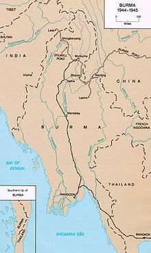
India-Myanmar-China Stilwell Road revival
Discussions are also proceeding on reopening the World War II-era Stilwell Road linking India's Assam state with China's Yunnan province through Myanmar.[21]
India–Myanmar–Thailand Trilateral Highway
India–Myanmar–Thailand Trilateral Highway, also known as the East-West Economic Corridor,[22] is a 3,200 km (2,000 mi) from India to Vietnam highway under upgrade under India's Look East policy, that will connect Moreh, India with Mae Sot, Thailand via Myanmar.[23] It is AH1 of Asian Highway Network. The road is expected to boost trade and commerce in the ASEAN–India Free Trade Area, as well as with the rest of Southeast Asia. India has also proposed extending the highway to Cambodia, Laos and Vietnam.[24]
India and ASEAN have plans to extend this route to Laos, Cambodia and Vietnam as this connectivity will generate annually, an estimated US$70 billion in incremental GDP and 20 million in incremental aggregate employment by 2025, and India has offered US$1 billion line-of-credit for this project (c. Dec 2017).[25]
Imphal-Moreh-Mandalay national highway upgrade
Imphal-Moreh-Mandalay Highway currently exists. In May 2017, the Indian Ministry of Road Transport and Highway stated that it would spend an estimated ₹7,500 million (US$100 million) to upgrade roads and highways in North East India in order to boost the region's connectivity with Myanmar and Bangladesh. Among these projects, the Ministry plans to widen the 108 km (67 mi) Imphal-Moreh highway in Manipur which currently serves as an important trade route between India and Myanmar.[26] This would provide the Manipur's capital city of Imphal with direct access to the trilateral highway.[26]
Mizoram-Mandalay new road construction
Mizoram-Kalemyo Highway is a new road planned by India. In May 2017, the Indian Ministry of Road Transport also plans to construct a 120 km (75 mi) highway linking Zokhawthar-Rih near Champhai, a border town in Mizoram, with the trilateral highway at Kalemyo. This will serve as a second route providing direct connectivity from Mizoram to the trilateral highway.[26]
Mago-Thingbu to Vijaynagar Border Road
The Mago-Thingbu–Vijaynagar Border Highway, also known as Arunachal Frontier Highway,[27] in Arunachal Pradesh India is a 2,000-kilometre-long (1,200 mi) road proposed to be built along the McMahon Line[28] (international border between India and China) by the Government of India at the cost of INR40,000 crore (approx. US$6.5 billion[29] as per 2014 prices).[30] Currently, along the alignment of this proposed road there is "little habitation" and there are only "small stretches of minor roads".[28] An assessment by the Ministry of Defence (India) in 2013 found that of the 503 stretches on the borders planned to be completed by 2022, only 17 are complete now. Work is underway on just 50.[31] In 2014 October, Kiren Rijiju, Union Minister of State for Home Affairs of India was trying to expedite the project along with another proposed highway East-West Industrial Corridor Highway, Arunachal Pradesh[27] in Arunachal Pradesh[30] as he said “I am proposing to undertake this road along with another in the foothill areas of Arunachal Pradesh state from Bhairabkunda in Assam located at the tri-junction of Bhutan, Assam and Arunachal Pradesh to Ruksin in East Siang district of Arunachal Pradesh state which will serve as an industrial corridor for the people residing in the foothill areas of the state”.[30]
Manipur-Mandalay bus service from 2018
Manipur-Mandalay bus service is pending subject to the signing of motor vehicle agreement. In September 2017, Indian ambassador to Myanmar announced that an Imphal-Mandalay India-Myanmar bus service will commence from 2018 after India and Myanmar sign the motor vehicle agreement.[32]
Imphal-Kalay-Mandalay flight
Imphal-Kalay-Mandalay flight is a proposed air service. In September 2017, Indian ambassador to Myanmar also proposed that a flight service from Imphal in Manipur to Mandalay via stopover in Kalay (Kalaymyo) in Sagaing Division of Myanmar could be started under UDAN regional connectivity scheme.[32] It was proposed to DoNER in 2012 and a successful trail run was conducted in December 2015.[33]
Tinsukia-Myitkyina railway
Tinsukia-Myitkyina railway is a proposed new railway link between the existing rail stations at Tinsukia-Doom Dooma in Assam state of India and Myitkyina in Kachin State of Myanmar, by laying new rail track via Shin Bway Yang and Sumprabum. Indian Railway uses broad gauge (1,676 mm or 5 ft 6 in) and Myanmar, Thailand, Vietnam and Malaysia use standard gauge (1 meter). In December 2017, India offered a US$1 billion line of credit to build connections to ASEAN nations.[34]
Imphal-Kalaymyo railway
Imphal-Kalaymyo railway is a proposed new railway link between the existing rail stations at Imphal in Manipur of India and Kalay in Myanmar. Indian Railway uses broad gauge (1,676 mm or 5 ft 6 in) and Myanmar, Thailand, Vietnam and Malaysia use standard gauge (1 meter). In December 2017, India offered a US1 billion line of credit to build connections to ASEAN nations.[34]
Aizawl-Wuntho railway
Aizawl-Wuntho railway is a proposed new railway link between the existing railway station at Wuntho in Myanmar and by extending the under construction Bairabi–Sairang line via Aizawl-Champhai in Manipur of India to Wuntho in Myanmar which currently goes further north up to Myitkyina towards China–Myanmar border. These are to be taken up with assistance of India's 1 billion line of credit for connections to ASEAN nations.[34]
Aizawl-Kalaymyo railway
Aizawl-Kalaymyo railway is a proposed new railway link between the existing railway station Kalay in Myanmar and by extending the under construction Bairabi–Sairang line via Aizawl-Champhai in Manipur of India to Kalay in Myanmar. These are to be taken up with assistance of India's 1 billion line of credit for connections to ASEAN nations.[34]
Aizawl-Kyauktaw-Sittwe railway
Aizawl-Kyauktaw-Sittwe railway is a proposed new railway link between the existing Kyauktaw-Sittwe railway in Myanmar and by extending the under construction Bairabi–Sairang line via Aizawl-Lunglei-Lawngtlai in Manipur of India to Sittwe Port in Myanmar developed by India. Kyauktaw to Minbu is an under construction railway to link Sittwe with the exiting Myanmar railway network. These are to be taken up with assistance of India's 1 billion line of credit for connections to ASEAN nations.[34]
India-Myanmar-Thailand railway
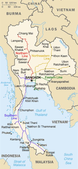
India-Myanmar-Thailand railway is a proposed new railway link, parts of which already exist, by constructing missing links between Aizawl and Imphal to Myanmar railway network and by linking existing railway lines in southern Myanmar Thailand rail network in 2 locations:
- Mongnai existing railway east in Myanmar to Chiang Mai in north-west Thailand
- Kyauk Shat or Dawei to Nam Tok near Bangkok
India-Myanmar-Thailand-Laos railway
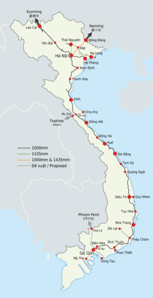
India-Myanmar-Thailand-Laos railway is a proposed new railway link, parts of which already exist, by constructing missing links between Aizawl and Imphal to Myanmar railway network and Myanmar-to-Thailand to connect railway in Laos. Laos only has one railway station in the whole nation, located 20 km east of Vientiane, that was built by State Railway of Thailand during 2007-09 by extending its metre-gauge network across the Thai–Lao Friendship Bridge from Thanaleng Railway Station in Thailand.[35] Test trains began running on July 4, 2008,[36] and Princess Maha Chakri Sirindhorn of Thailand formally inaugurated the line on March 5, 2009.[37][38] There is also an under-construction (2017) Keng Tung railway line in east Myanmar that can be extended to Laos in future.
Laos-Vietnam railway: In 2012, an agreement for the construction of 220-kilometre $5 billion line, from Savannakhet in south Laos to Port of Vũng Ang in Vietnam, via Mụ Giạ Pass and Tan Ap (intersects Vietnam railway network), was awarded to a Malaysian company "Giant Consolidated Limited" to complete the construction from 2013 to 2017.[39][40] By December 2016, installation of corridor posts along the proposed railway right-of-way was completed.[41] In future, Savannakhet is planned to be connected to the existing railway in Thailand at Khon Kaen or Ubon Ratchathani.
India-Myanmar-Thailand-Cambodia railway
India-Myanmar-Thailand-Cambodia railway link is a proposed new railway link, parts of which already exist, by constructing missing links between Aizawl and Imphal to Myanmar railway network, to Thailand, to Combodia to connect the rail network in Cambodia. Cambodia has existing rail link with Thailand at Poipet (Krong Poi Pet), though train services is currently suspended (2017).
India-Myanmar-Thailand-Cambodia-Vietnam railway
India-Myanmar-Thailand-Cambodia-Vietnam railway is a proposed new railway link, parts of which already exist, by constructing missing links between Aizawl and Imphal to Myanmar railway network, to Thailand, to Combodia to connect Vietnam Railways. Cambodia has existing rail link with Thailand at Poipet (Krong Poi Pet) though train services is currently suspended (2017) and Phnom Penh-Hoa Lu-Dĩ An connection with Vietnam is under construction (2017), while there is no current or planned rail connection to Laos. Indian Railway uses broad gauge (1,676 mm or 5 ft 6 in) and Myanmar, Thailand, Vietnam and Malaysia use standard gauge (1 meter).
India-Myanmar-Thailand-Malaysia-Singapore railway
India-Myanmar-Thailand-Malaysia-Singapore railway is a proposed new railway link as part of the Trans-Asian Railway, parts of which already exist, by using existing metre-gauge connections of Thai railway network to railway network in Malaysia (at Palang Besar in north west and Tumpat in north east Malaysia) and Kuala Lumpur–Singapore high-speed rail (being constructed between 2017-26[42]). Two rail crossings along the Malaysian-Thai border are:
- Padang Besar, Malaysia-Padang Besar, Thailand: Both the Malaysian and Thai towns where the crossing is located are known by the same name. This crossing connects to Malaysia's West Coast trunk line and Thailand's main southern line to Bangkok via Hat Yai. Both Malaysian and Thai customs, immigration and quarantine formalities are conducted at Malaysia's Padang Besar railway station.
- Rantau Panjang-Sungai Kolok: On the Malaysian side, this bridge crossing is on a branch line which is connected to Malaysia's East Coast line. In Thailand, the crossing is connected to the Su-ngai Kolok branch line which links up with the main southern line at Hat Yai. The crossing is currently not in use (January 2018).
See also
References
- 1 2 Bhonsle, Col. Rahul K. (July 28, 2007). "India's 'Look Myanmar' Policy". Boloji.com. Retrieved 2007-10-10.
- ↑ "India, Burma to fence the border". Mizzima News. May 17, 2003. Retrieved 2007-10-10.
- 1 2 Khaund, Surajit (15 October 2004). "India-Burma border fencing delays due to protest by local communities". Burma News International. Retrieved 2007-10-10.
- ↑ "New effort: India-Myanmar to begin talks". Times of India. September 2, 2007. Retrieved 2007-10-10.
- ↑ Home ministry looks to form 29-battalion Indo-Myanmar border force, Hindustan Times, 18 Jan 2018.
- 1 2 India opens two border crossing points with Myanmar, Bangladesh, Indian Express, 1 Oct 2017.
- ↑ "India-Myanmar Border Problems: Fencing not the only solution - Institute for Defence Studies and Analyses". www.idsa.in.
- ↑ "Northeast India | Straddling Different Boundaries". The Statesman.
- ↑ "Tedim Road—The Strategic Road on a Frontier: A Historical Analysis - Institute for Defence Studies and Analyses". www.idsa.in.
- ↑ Multi-modal route map
- ↑ India awards road contract to complete Kaladan project in Myanmar, Business Line, 9 June 2017.
- ↑ "Bharatmala presentation" (PDF).
- ↑ From Mon in Nagaland to Myanmar, Schoolkids Cross the Border For a Better Future, The Wire, .
- ↑ An Indian Village Where Villagers Have Dual Citizenships And Its King Has 60 Wives, Daily Moss, 22 Msay 2015.
- ↑ "Asia Times Online :: South Asia news - India rediscovers East Asia". www.atimes.com.
- ↑ "Sino-Indian relations".
- ↑ "Vietnam among pillars of India's "Look East" policy". english.vietnamnet.vn. Vietnam News Agency. 18 November 2013. Retrieved 18 November 2013.
- ↑ "Modi govt to give greater push to India's Look East Policy, says Sushma Swaraj". Firstpost. 2014-08-25. Retrieved 2014-09-10.
- ↑ "Sushma Swaraj tells Indian envoys to Act East and not just Look East". The Economic Times. 26 August 2014.
- ↑ "India's 'Look East' Policy Pays off". www.globalpolicy.org.
- 1 2 "Asia Times Online :: South Asia news, business and economy from India and Pakistan". www.atimes.com.
- ↑ "Myanmar Road Project Hooks 1.8 Billion Baht From Thailand". The Irrawaddy. 2 February 2017. Retrieved 12 February 2017.
- ↑ "All you want to know about Delhi to Bangkok Road Trip - Myths & Reality". Tripoto. 11 September 2015. Retrieved 20 September 2015.
- ↑ "Highway pact after car rally".
- ↑ http://www.financialexpress.com/india-news/government-asean-in-talks-to-take-imt-highway-up-to-vietnam/970887/ Asean in talks to take IMT highway up to Vietnam], 12 Dec 2017.
- 1 2 3 Bose, Pratim Ranjan (24 February 2017). "₹7,500-crore road network to boost North-East economy". The Hindu Business Line. Retrieved 1 June 2017.
- 1 2 "Narendra Modi government to provide funds for restoration of damaged highways". Diligent Media Corporation Ltd. Retrieved 27 October 2014.
- 1 2 "Top officials to meet to expedite road building along China border". Dipak Kumar Dash. timesofindia.indiatimes.com. Retrieved 27 October 2014.
- ↑ "Indian Government Plans Highway Along Disputed China Border". Ankit Panda. thediplomat.com. Retrieved 27 October 2014.
- 1 2 3 "Govt planning road along McMohan line in Arunachal Pradesh: Kiren Rijiju". Live Mint. Retrieved 2014-10-26.
- ↑ "Army's border roads in trouble: The planned road network along the border with China is stuck in red tape and impeded by terrain". Daily Mail Online. Associated Newspapers Ltd. 27 August 2013. Retrieved 27 October 2014.
- 1 2 Imphal-Mandalay bus service likely to begin from next year., Imphal Times, 9 Sept 2017.
- ↑ Imphal-Mandalay bus service trial run, Dec 2015.
- 1 2 3 4 5 India proposed $1 billion credit for connectivity with ASEAN: Nitin Gadkari, Financial Express, December 2017.
- ↑ "Laos link launched". Railway Gazette International. 2007-03-01.
- ↑ "Testing takes train into Laos". Railway Gazette International. 2008-07-07.
- ↑ "Inaugural train begins Laos royal visit". Railway Gazette International. 2009-03-05.
- ↑ Andrew Spooner (2009-02-27). "First train to Laos". The Guardian. Retrieved 2011-03-13.
- ↑ Limited, Bangkok Post Public Company. "Laos to build railway to Vietnam".
- ↑ "Savan-Laobao railway corridor approved". Savan Pacifica Development Co.Ltd. 2016-04-15. Retrieved 2017-06-26.
- ↑ "Investor: Preparation for Savan-Lao Bao railway construction 'well progressed'". Vietstock. 2017-03-14. Retrieved 2017-06-26.
- ↑ "Malaysia-Singapore high-speed rail project to commence in 2017". TheMalayMailOnline.com. 2 September 2015. Retrieved 22 April 2017.