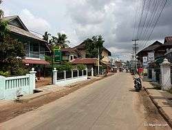
Dawei
| Dawei ထားဝယ်မြို့ Tavoy | |
|---|---|
| City | |
 | |
 Dawei Location in Myanmar (Burma) | |
| Coordinates: 14°05′0″N 98°12′0″E / 14.08333°N 98.20000°E | |
| Country |
|
| Region |
|
| District | Dawei District |
| Township | Dawei Township |
| Capital | Dawei |
| Population (2005) | |
| • Religions | Theravada Buddhism |
| Time zone | UTC+6.30 (MMT) |
| Area code(s) | 59[1] |
Dawei (Burmese: ထားဝယ်မြို့; MLCTS: hta: wai mrui., pronounced [dəwɛ̀ mjo̰]; Mon: ဓဝဲါ, [həwài]; Thai: ทวาย, RTGS: Thawai, pronounced [tʰā.wāːj]; formerly known as Tavoy) is a city in south-eastern Myanmar and is the capital of the Tanintharyi Region, formerly known as the Tenasserim Division, about 614.3 km (381.7 mi) south of Yangon on the northern bank of the Dawei River. Population (2004 estimate), 139,900. It is at 14.09°N 98.20°E. Dawei is a port at the head of the Dawei River estuary, 30 km (18.6 mi). from the Andaman Sea. As a result, the city is prone to flooding during the monsoon season. "Dawei" is also the name of one of Myanmar's 135 ethnic minorities.
Etymology
"Dawei" derives from the Mon language term "Hawai" (Mon: ထဝဲါ; /həwai/), which means "to sit cross-legged," in reference to the Buddha's sitting posture on the palin (throne).[2][3]
History
The area around the Dawei River estuary has been inhabited for centuries by Dawei, Mon, Kayin, and Thai mariners. From the 11th to 13th centuries, Dawei was part of the Pagan Empire. From 1287 to 1564, Dawei became part of the Sukhothai Kingdom and its successor Ayutthaya Kingdom (Siam). From 1564 to 1594, Dawei was part of the Toungoo Kingdom of Burma. Siam temporarily regained the city between 1594 and 1614. From 1614 to the 1740s, Dawei was the southernmost city under Burmese authority, and was defended by a Burmese garrison. In the late 1740s during the Burmese civil war of 1740–1757, Dawei, along with the northern Tenasserim coast, was taken over by Siam. Burma regained the city in 1760, and extended its control over the entire Tenasserim coast in 1765. The Tenasserim coast was ceded to the British after the First Anglo-Burmese War (1824–1826).
After independence in 1948, the city became part of the Tenasserim Division, which also included today's Mon State. In 1974, Mon State was carved out of Tenasserim and Dawei became the capital of the truncated Division. In 1989, the city's English name was changed from Tavoy to Dawei, and Tenasserim became Tanintharyi.
Climate
Dawei features an extreme tropical monsoon climate (Köppen climate classification Am), similar to Sittwe further north-west. There is a substantial dry season from November to April, but in the wet season the influence of local mountains causes Dawei to receive as much as 1,300 millimetres (51 in) precipitation per month. Apart from the Chocó region of Colombia, and the area around Mount Cameroon in Africa, it is possibly the wettest lowland tropical region in the world.
| Climate data for Dawei (1981–2010) | |||||||||||||
|---|---|---|---|---|---|---|---|---|---|---|---|---|---|
| Month | Jan | Feb | Mar | Apr | May | Jun | Jul | Aug | Sep | Oct | Nov | Dec | Year |
| Average high °C (°F) | 33.3 (91.9) |
34.1 (93.4) |
34.7 (94.5) |
35.0 (95) |
32.0 (89.6) |
29.4 (84.9) |
28.7 (83.7) |
28.4 (83.1) |
29.7 (85.5) |
31.7 (89.1) |
32.8 (91) |
32.6 (90.7) |
31.9 (89.4) |
| Average low °C (°F) | 18.4 (65.1) |
19.6 (67.3) |
21.2 (70.2) |
23.3 (73.9) |
23.7 (74.7) |
23.2 (73.8) |
22.7 (72.9) |
22.8 (73) |
22.7 (72.9) |
22.5 (72.5) |
20.8 (69.4) |
18.2 (64.8) |
21.6 (70.9) |
| Average rainfall mm (inches) | 5.8 (0.228) |
16.6 (0.654) |
39.5 (1.555) |
115.3 (4.539) |
536.3 (21.114) |
1,099.4 (43.283) |
1,201.4 (47.299) |
1,310.4 (51.591) |
707.3 (27.846) |
355.8 (14.008) |
44.5 (1.752) |
7.6 (0.299) |
5,439.9 (214.169) |
| Source: Norwegian Meteorological Institute[4] | |||||||||||||
Transport
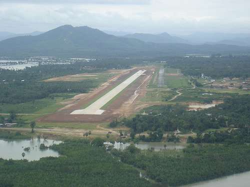
Only recently was Dawei connected to the rest of Myanmar by road and rail. There are plans to construct a deep water port in Dawei.[5] In November 2010, the Myanmar Port Authority signed a US$8.6 billion deal with Italian-Thai Development to develop the seaport at Dawei.[6] The Dawei Special Economic Zone would become Myanmar's first special economic zone (SEZ), which includes plans to develop a 250 square kilometres (97 sq mi) industrial estate, with sea, land (railway and road) infrastructure links to Thailand, Cambodia, and Vietnam, as well as a gas pipeline to Thailand's Kanchanaburi Province and commercial and residential developments.[7][8] The development of the SEZ has been linked to land confiscations and land grabs from farmers of upwards of 63,768 acres (258.06 km2) (direct) and 153,919 acres (622.89 km2), potentially displacing 500,000 Dawei natives.[9]
A transnational highway and a railway line across the Tenasserim Hills connecting Dawei and Bangkok are planned if the deep water port project goes ahead.[10] This port could significantly reduce Singapore-bound traffic when completed.[11]
Economy
Dawei longyis (sarong) are one of the area's well-known products.[12] The area produces rubber, dried fish, and teakwood. It also produces cashew nuts and betel nuts and exports them through local traders to China, India, and Thailand. Dawei is also well known for its variety of tropical fruits such as pineapples, a variety of mangoes, mangosteens, and durian. There is one fruit called zin thi (in Dawei language), which can only be found in Dawei and surrounding areas; this fruit is sweet with a touch of sour.
Dawei is also getting a proposed special economic zone plus deep sea port called the Dawei Port Project. It is undergoing construction with companies providing a road link to Thailand, port construction, and a rail connection. It is partly being developed by Italian and Thai companies.
Higher education
- Dawei Education College
- Dawei University
- Technological University, Dawei
- Computer University, Dawei
Notable residents
- Ba Htoo (1916-1945), one of the commanders of General Aung San's Burma Independence Army who fought against Japanese.
- Ba Swe, 2nd Prime Minister of Union of Burma
- Min Aung Hlaing
- Richard Bartholomew
- [U Ngwe Kai (Painting Artist of Myanmar)]
- [U Han Tin (Woodcarver)]
See also
References
- ↑ "Myanmar Area Codes". Retrieved 2009-04-10.
- ↑ Tun, Than (1988). "Observations on the Translation and Annotation of the Royal Orders Of Burma". Crossroads: An Interdisciplinary Journal of Southeast Asian Studies. 4 (1): 91–99.
- ↑ Banyar, Ko (7 November 2013). "မွန်တို့ဌာနေ ရာမည တိုင်းက မွန် အခေါ်အဝေါ်များ". Phophtaw News Association.
- ↑ "Myanmar Climate Report" (PDF). Norwegian Meteorological Institute. pp. 26–36. Archived from the original (PDF) on 8 October 2018. Retrieved 8 October 2018.
- ↑ "Railway Gazette: China's horizons extend southwards". 2011-01-06. Retrieved 2011-01-06.
- ↑ Aye Thidar Kyaw; Stuart Deed (7 February 2011). "SPDC signs Special Economic Zone law into effect on Jan 27". Myanmar Times. Archived from the original on 16 September 2011. Retrieved 23 August 2011.
- ↑ Thein Linn (4 November 2010). "Dawei deep-sea port, SEZ gets green light". Myanmar Times. Archived from the original on 31 August 2011. Retrieved 23 August 2011.
- ↑ "Italian-Thai takes lead in delayed Dawei". Investvine.com. 2012-10-30. Retrieved 2013-02-27.
- ↑ Loewen, Elizabeth (September 2012). "Land Grabbing in Dawei (Myanmar/Burma): a (Inter)national Human Rights Concern" (PDF). Transnational Institute.
- ↑ Table A1-1-1a. Prospective projects in Mekong sub-region
- ↑ http://www.smetimes.in/smetimes/news/top-stories/2013/Aug/12/india-to-link-Myanmar-port-to-boost-connectivity-with629899.html
- ↑ "Dawei Traditional Longyi Weaving Art inc. video". Archived from the original on 2007-10-06.
External links
Capital: Dawei | |
|
Capital: Dawei | ||
| Dawei District |  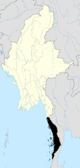 | |
| Kawthaung District |
| |
| Myeik District | ||
| Main cities and towns | ||