Savannakhet
| Savannakhet ເມືອງໄກສອນ ພົມວິຫານ | |
|---|---|
| Muang (district) | |
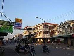 The commercial centre of Kaysone Phomvihane, Savannakhet Province | |
 Savannakhet | |
| Coordinates: 16°33′N 104°45′E / 16.550°N 104.750°E | |
| Country |
|
| Province | Savannakhet Province |
| Population | |
| • Total | 120,000 |
| Time zone | UTC+7 (ICT) |
Savannakhet, officially named Kaysone Phomvihane (Lao: ໄກສອນ ພົມວິຫານ; Thai: ไกสอน พมวิหาน) and previously known as Khanthabouli (ຄັນທະບູລີ), is a city in western Laos and the capital of the Savannakhet Province. With a population of 120,000 (undated), it is the second-largest city in Laos, after Vientiane. The city is the birthplace of Kaysone Phomvihane, the first leader of Laos from independence in 1975 to 1992, and was named after him in 2005. Although the old French colonial quarter of the town, along the Mekong River-front, is depressed and crumbling, the town's proximity to Thailand's booming economy has brought about new commercial development in the northern part of the town, near both the river crossing and the bus terminal.
Like all Lao cities, Savannakhet has a mixed population of Lao, Thai, Vietnamese and Chinese, as well as minority peoples from the Lao interior. It has a large 15th-century Buddhist temple, Wat Sainyaphum, a Chinese temple, the Catholic Co-Cathedral of St. Therese and a mosque. The Second Thai–Lao Friendship Bridge over the Mekong connects to Mukdahan Province in Thailand. The two-lane, 12-metre-wide (39 ft), 1,600-metre-long (5,250 ft) bridge opened to the general public on 9 January 2007.
Transport
The city is served by Savannakhet Airport.
Climate
Savannakhet features a tropical savanna climate (Aw) according to Köppen climate classification with a little subtropical climate characteristics as the city located 16.5° north of the equator. The hottest month is April (mean = 29.5 °C (85.1 °F)) with temperature ranging from 23.9 °C (75.0 °F) to 35.2 °C (95.4 °F), while the coolest month is December (mean = 21.7 °C (71.1 °F)) with temperature ranging from 15.2 °C (59.4 °F) to 28.7 °C (83.7 °F). The diurnal temperature variation seems to be greater during winter due to dry conditions. The city experiences dry season during winter months and wet season during summer months due to activation of monsoon. The driest month is December with precipitation total 2.0 millimetres (0.079 in), while the wettest month is August with precipitation total 323.1 millimetres (12.72 in).
| Climate data for Savannakhet, Laos (1981-2010) | |||||||||||||
|---|---|---|---|---|---|---|---|---|---|---|---|---|---|
| Month | Jan | Feb | Mar | Apr | May | Jun | Jul | Aug | Sep | Oct | Nov | Dec | Year |
| Record high °C (°F) | 37.2 (99) |
39.2 (102.6) |
39.6 (103.3) |
41.1 (106) |
41.2 (106.2) |
38.0 (100.4) |
38.5 (101.3) |
36.1 (97) |
38.0 (100.4) |
35.0 (95) |
37.2 (99) |
38.0 (100.4) |
41.2 (106.2) |
| Average high °C (°F) | 29.2 (84.6) |
32.0 (89.6) |
34.6 (94.3) |
35.2 (95.4) |
33.3 (91.9) |
32.8 (91) |
31.9 (89.4) |
31.0 (87.8) |
31.6 (88.9) |
30.9 (87.6) |
30.4 (86.7) |
28.7 (83.7) |
31.8 (89.2) |
| Daily mean °C (°F) | 22.7 (72.9) |
24.8 (76.6) |
28.1 (82.6) |
29.5 (85.1) |
29.3 (84.7) |
28.7 (83.7) |
27.6 (81.7) |
27.6 (81.7) |
27.6 (81.7) |
26.6 (79.9) |
24.0 (75.2) |
21.7 (71.1) |
26.5 (79.7) |
| Average low °C (°F) | 15.1 (59.2) |
18.3 (64.9) |
21.7 (71.1) |
23.9 (75) |
24.2 (75.6) |
25.1 (77.2) |
24.3 (75.7) |
24.2 (75.6) |
23.4 (74.1) |
21.6 (70.9) |
19.0 (66.2) |
15.2 (59.4) |
21.3 (70.3) |
| Record low °C (°F) | 8.0 (46.4) |
10.0 (50) |
10.0 (50) |
15.0 (59) |
17.5 (63.5) |
19.0 (66.2) |
18.2 (64.8) |
18.0 (64.4) |
18.0 (64.4) |
14.0 (57.2) |
6.0 (42.8) |
3.0 (37.4) |
3.0 (37.4) |
| Average precipitation mm (inches) | 2.4 (0.094) |
24.2 (0.953) |
41.7 (1.642) |
99.4 (3.913) |
215.8 (8.496) |
224.6 (8.843) |
274.5 (10.807) |
323.1 (12.72) |
249.4 (9.819) |
117.8 (4.638) |
13.8 (0.543) |
2.0 (0.079) |
1,588.7 (62.547) |
| Average precipitation days (≥ 1.0 mm) | 2.9 | 4.6 | 3.9 | 8.0 | 17.6 | 17.9 | 20.9 | 20.7 | 19.8 | 11.5 | 4.0 | 2.3 | 134.1 |
| Source: Meteo Climat[1] | |||||||||||||
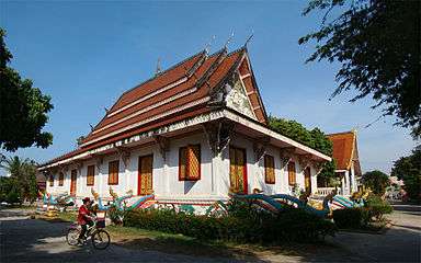 Wat Sainyaphum
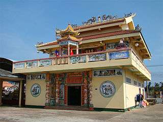 Chinese Buddhist Temple
 Vietnamese Buddhist Temple Diệu Giác
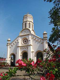 St. Teresa's Catholic Church
Sister cities
References
- ↑ "Station Savannakhet" (in French). Meteo Climat. Retrieved 29 December 2016.
External links
| Wikimedia Commons has media related to Savannakhet. |

| Attapeu | |
|---|---|
| Bokeo | |
| Bolikhamsai | |
| Champasak | |
| Houaphanh | |
| Khammouane | |
| Luang Namtha | |
| Luang Prabang | |
| Oudomxay | |
| Phongsaly | |
| Salavan | |
| Savannakhet | |
| Sekong | |
| Vientiane |
|
| Vientiane (Viengchan) |
|
| Xaignabouli |
|
| Xaisomboun |
|
| Xiangkhouang | |