Ubon Ratchathani
- Ubon Ratchathani is both a city and a province in Thailand. For the province, see Ubon Ratchathani province.
| Ubon Ratchathani อุบลราชธานี | ||
|---|---|---|
| City Municipality | ||
|
City of Ubon Ratchathani เทศบาลนครอุบลราชธานี | ||
 | ||
| ||
| Nickname(s): Ubon | ||
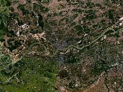
 Ubon Ratchathani Location in Thailand | ||
| Coordinates: 15°13′41″N 104°51′34″E / 15.22806°N 104.85944°E | ||
| Country | Thailand | |
| Province | Ubon Ratchathani | |
| District | Mueang Ubon Ratchathani | |
| Government | ||
| • Type | City Municipality | |
| • Mayor | Sompratana Wikraijerdcharoen | |
| Area | ||
| • Total | 29.04 km2 (11.21 sq mi) | |
| Elevation | 125 m (410 ft) | |
| Population (2000)[1] | ||
| • Total | 106,602 | |
| Time zone | UTC+7 (ICT) | |
| Postcode | 35000 | |
| Area code | (+66) 45 | |
| Website |
cityub | |


-1.jpg)
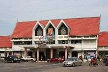
Ubon Ratchathani (Thai: อุบลราชธานี, pronounced [ʔubon râːt.tɕʰa.tʰaːniː]) is one of the four major cities of Isan (Khorat/Nakhon Ratchasima, Ubon Ratchathani, Udon Thani, and Khon Kaen), also known as the "big four of Isan". The city is on the Mun River in the southeast of the Isan region of Thailand. It is known as Ubon (อุบลฯ) for short. The name means 'royal lotus city'. The provincial seal features a pond with a lotus flower and leaves in a circular frame. Ubon was the administrative centre of Ubon Ratchathani Province.[2] As of 2006, the Ubon urban area had a population of about 200,000. This included 85,000 in Thetsaban Nakhon Ubon Ratchathani (Ubon municipality), 30,000 each in Thetsaban Mueang Warin Chamrap (Warin municipality) and Thetsaban Tambon Kham Yai, 24,000 in Thetsaban Tambon Saen Suk, 10,000 in each of Thetsaban Tambon Pathum and Tambon Kham Nam Saep, and 6,000 in Thetsaban Tambon Ubon.
Ubon Ratchathani is 615 km from Bangkok.[3]
History

The city was founded in the late 18th century by Thao Kham Phong, descendant of Phra Wo and Phra Ta, who escaped from King Siribunsan of Vientiane into Siam Kingdom during the reign of King Taksin the Great. Later Thao Kham Phong was appointed to be "Phra Pathum Wongsa" (Thai: พระประทุมวงศา) and the first ruler of Ubon Ratchathani. In 1792 Ubon Ratchathani became a province, and was also the administrative center of the monthon Isan. Until 1972 Ubon Ratchathani was the largest province of Thailand by area. Yasothon Province was split off from Ubon Ratchathani Province in 1972, followed by Amnat Charoen Province in 1993. Ubon Ratchathani Province now ranks the fifth in area.
Ubon Ratchathani sits on the north bank of the Mun River. The south bank of the river is occupied by the suburb of Warin Chamrap (Warin for short), which is effectively incorporated into the city.
The city was attacked by French forces in 1940 in retaliation for Thai attacks on French Indochinese towns.
Ubon grew extensively during World War II when Japanese forces brought in prisoners of war by rail from Kanchanaburi. One legacy of this is a monument in the city's central Thung Si Meuang Park erected by British prisoners of war in gratitude to the citizens of Ubon for assisting them. During the Vietnam war, United States armed forces constructed Ubon Royal Thai Air Force Base, which is now also a dual-use commercial airport.
Lao influence is evident in the architectural structure of some of the city's religious buildings.
The city has branches of the National Archives of Thailand and National Museum of Thailand.
Climate
Ubon Ratchathani has a tropical wet and dry climate (Köppen climate classification Aw). Winters are dry and very warm. Temperatures rise until April, which is very hot with an average daily maximum of 36.4 °C (97.5 °F). The monsoon season runs from late April–October, with heavy rain and somewhat cooler temperatures during the day, although nights remain warm.
| Climate data for Ubon Ratchathani (1981–2010) | |||||||||||||
|---|---|---|---|---|---|---|---|---|---|---|---|---|---|
| Month | Jan | Feb | Mar | Apr | May | Jun | Jul | Aug | Sep | Oct | Nov | Dec | Year |
| Record high °C (°F) | 37.2 (99) |
39.2 (102.6) |
40.6 (105.1) |
42.0 (107.6) |
41.2 (106.2) |
38.3 (100.9) |
38.5 (101.3) |
35.8 (96.4) |
37.1 (98.8) |
35.2 (95.4) |
36.5 (97.7) |
35.9 (96.6) |
42.0 (107.6) |
| Average high °C (°F) | 31.7 (89.1) |
34.0 (93.2) |
35.8 (96.4) |
36.4 (97.5) |
34.7 (94.5) |
33.3 (91.9) |
32.6 (90.7) |
31.9 (89.4) |
31.8 (89.2) |
31.8 (89.2) |
31.4 (88.5) |
30.6 (87.1) |
33.0 (91.4) |
| Daily mean °C (°F) | 24.2 (75.6) |
26.5 (79.7) |
28.9 (84) |
30.0 (86) |
29.0 (84.2) |
28.4 (83.1) |
28.0 (82.4) |
27.6 (81.7) |
27.4 (81.3) |
26.8 (80.2) |
25.4 (77.7) |
23.7 (74.7) |
27.2 (81) |
| Average low °C (°F) | 17.5 (63.5) |
19.9 (67.8) |
22.5 (72.5) |
24.4 (75.9) |
24.5 (76.1) |
24.4 (75.9) |
24.2 (75.6) |
23.9 (75) |
23.7 (74.7) |
22.5 (72.5) |
20.3 (68.5) |
17.8 (64) |
22.1 (71.8) |
| Record low °C (°F) | 10.0 (50) |
11.7 (53.1) |
10.3 (50.5) |
16.4 (61.5) |
20.6 (69.1) |
20.2 (68.4) |
20.0 (68) |
20.0 (68) |
19.2 (66.6) |
15.9 (60.6) |
13.3 (55.9) |
8.9 (48) |
8.9 (48) |
| Average rainfall mm (inches) | 2.0 (0.079) |
15.4 (0.606) |
30.5 (1.201) |
86.8 (3.417) |
208.6 (8.213) |
240.2 (9.457) |
254.4 (10.016) |
303.3 (11.941) |
293.8 (11.567) |
123.1 (4.846) |
22.6 (0.89) |
1.0 (0.039) |
1,581.7 (62.272) |
| Average rainy days | 0.6 | 1.4 | 3.5 | 7.5 | 15.4 | 17.6 | 18.8 | 21.0 | 19.0 | 11.3 | 3.6 | 0.6 | 120.3 |
| Average relative humidity (%) | 65 | 63 | 62 | 66 | 75 | 79 | 80 | 82 | 82 | 78 | 71 | 68 | 73 |
| Mean monthly sunshine hours | 226.3 | 211.9 | 201.5 | 186.0 | 158.1 | 117.0 | 120.9 | 117.8 | 108.0 | 145.7 | 186.0 | 223.2 | 2,002.4 |
| Mean daily sunshine hours | 7.3 | 7.5 | 6.5 | 6.2 | 5.1 | 3.9 | 3.9 | 3.8 | 3.6 | 4.7 | 6.2 | 7.2 | 5.5 |
| Source #1: Thai Meteorological Department[4] | |||||||||||||
| Source #2: Office of Water Management and Hydrology, Royal Irrigation Department (sun and humidity)[5] | |||||||||||||
Festivals
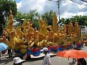
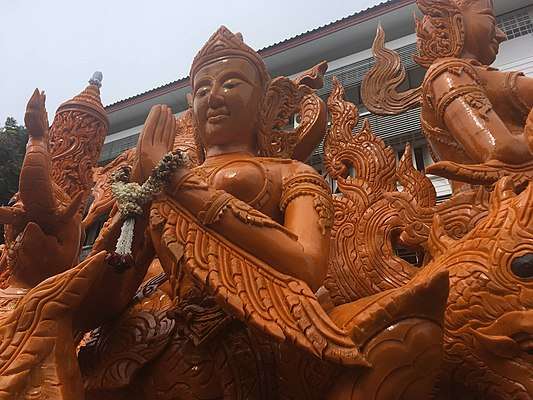
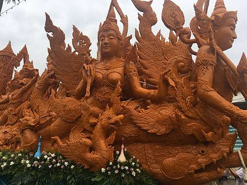
Ubon is best known for its annual Candle Festival, held in July to mark the beginning of the rainy season retreat for Buddhists, Wan Khao Phansa, also called Buddhist Lent. One day prior, candles are taken to Thung Si Mueang, the central park in the middle of the city, to be decorated and then exhibited in the evening. On the same evening, there are many smaller processions to bring candles to practically all Buddhist temples in Thailand. The main procession in Ubon takes place early the following morning.
Sights and attractions
The province is known for its strong Buddhist tradition, particularly the practice of monks dwelling in the forest (Thai: พระธุดงค์ Phra thudong, pilgrimage, lit. "hiking monk"). Wat Nong Pah Pong, for example, is a Buddhist forest monastery in the Thai Forest Tradition, which was established by Venerable Ajahn Chah Subhaddo in 1954. Ajahn Chah's style of teaching and personality had a notable ability to reach people of other nationalities. Many foreigners came to learn from, train under, and be ordained by Ajahn Chah. Wat Pa Nanachat (International Forest Monastery) was then established in 1975. Since that time, Wat Pa Nanachat has become a respected forest monastery. It currently includes under its umbrella over fifty monks representing twenty-three nationalities.
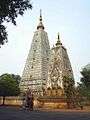
Other Buddhist temples, in and around the city, include Wat Thung Si Mueang (Thai: วัดทุ่งศรีเมือง), in the centre of the city featuring an old wooden library on stilts in a small lake, and Wat Nong Bua near the Big C mall, featuring a chedi (temple) modelled on Bodh Gaya in India.
Education
High Schools
Two major high schools in the central part of Ubon Ratchathani. These two schools are aged more than 100 years old.
- Benchama Maharacha School (Thai: เบ็ญจะมะมหาราช), which offers an English language stream.
- Narinukun School, which offers an English language stream.
- Ave Maria School.
- Assumption School, next to the Tesco-Lotus store on Chayangkun Road is a private Catholic school.
Higher education
- Ubon Ratchathani University, a rural campus 15 kilometres (9.3 mi) south of the city, but accessible by two songthaew routes.
- Ubon Ratchathani Rajabhat University, an upgraded technical college just north of the central city.
- Ratchathani University, a private university with a large campus between the km5 post on the Ring Road and the Mun River.
- Mahachulalongkorn Ratchawitthayalai University is a Bangkok Buddhist university with a small campus on Wat Mahawanaram in the city, and a new and much larger, but isolated campus in Tambon Krasop, northeast of the Ring Road.
- North Eastern Polytechnic College, with a campus on Chayangkun Road near the Big C Mall.
- Ubon Polytechnic College, with a campus on Chongkonnithan Road west of the city centre.
- Ratchathani Technology Vocational College, north of the Ring Road on Ubon 2 Road.
- Sukhothai Thammathirat Open University, while Bangkok-based, operates the small Sun Witthaya Phatthana Ubon Ratchathani centre next to the National Archives, a block west of the Ring Road.
- Ubon Ratchathani Technical College is near SK Mall.
- Ubon Ratchathani Vocational College, on Phrommarat Road in the city centre.
- Boromarajonani College of nursing Sappasithipasong, a block east of Sapphasit Prasong hospital.
Transportation
Airport
Ubon Ratchathani International Airport ( IATA: UBP) As well as being a commercial facility, Ubon Ratchathani Airport is also an active Royal Thai Air Force (RTAF) base, the home of 2nd Air Division/21st Wing Air Combat Command. During the Vietnam War, US and Australian squadrons were based here.
Nok Air, AirASia and Lion air have operated multiple flights from Don Muang Internationl Airport (DMK) to Ubon Ratchathani Airport (UBP) Nok Air operates flights from Udonthani to UbonRatchathani. Thai Smile operates flights from Suvarnabhumi International Airport (BKK) to UBP
Bus terminal
The town's main bus station is in the northwest of the city, on the Ring Road (Highway 231), 500 m west of its intersection with Chayangkun Road (Highway 212) outskirts of the city and clsoe to Big C store.
Nakhonchai Air operates its own private bus terminal just across the main bus station.
There are buses from this main bus station to Chong Meg (Boarder to Laos), to Pak Se ( Laos PDR) ,Chong Jom (Border to Cambodia)
Many taxis, bike taxis are awaiting in front of the main entrance of the bus station. There are Song Taew to the city, just less than 30 THB. Song Taew No.11 will take you to the old town area and ends at Tourism Authority of Thailand (TAT) at KuenThani Road in old town.
Railway terminal
The eastern terminus of the north-eastern railway line from Hua Lamphong Railway Station, Bangkok's central station, is in Warin Chamrap. The railhead reached Warin in April 1930. The terminal station is called Ubon Ratchathani, but is in Warin Chamrap municipalit which is located in the South of Ubon Ratchathani.Take 10 minutes ride from the railway station to the old town.
Within the city
There are presently (2012) two taxi companies. Tuk-tuks can be found at the main shopping malls and markets, and charge fixed prices to various destinations such as the airport or railway station. Regular public transport is by songthaew, which operate frequently between 06:00 and 18:00, on fixed routes for 10–15 baht per trip. Routes are indicated by numbers and the colour of the vehicle. All routes pass through the centre of Ubon and/or Warin cities. Route 8 is a ring route through Ubon city. No songthaews serve the airport, so airline passengers must use tuk-tuks instead.
From the airport, Turn right and walk straight to the main gate, you will see the Taxi meters from blue/yellow. They are quite trustful so no worry about cheating or ripping off. To the old town will cost you around 60 THB (2 USD) If you wish to explore the suburban of Ubon Ratchathni andtravel in a group, rental car is suggested.
Grab Car is also available too.
There is a project called 'รถสองแถวอุบลเด้อจ้า' by students from Ubon Ratchathani University which provide routes of Songtaew in Ubon Rtchathani in both Thai and English.
If you wish to use the local ways to explore the city. You can download a map from their site.
Gallery
 Chedi, Wat Nong Bua
 Library, Thung Si Mueang temple
 Songthaew near Thung Si Mueang
 Night market
References
- ↑ "City Population". CityPopulation.de. Retrieved February 4, 2013.
- ↑ "Ubon Ratchathani". Tourism Authority of Thailand (TAT). Archived from the original on 25 June 2015. Retrieved 15 June 2015.
- ↑ "Distance: Bangkok to Ubon". Google Maps. Retrieved 15 June 2015.
- ↑ "Climatological Data for the Period 1981–2010". Thai Meteorological Department. p. 12. Retrieved 2 August 2016.
- ↑ "ปริมาณการใช้น้ำของพืชอ้างอิงโดยวิธีของ Penman Monteith (Reference Crop Evapotranspiration by Penman Monteith)" (PDF) (in Thai). Office of Water Management and Hydrology, Royal Irrigation Department. p. 56. Retrieved 2 August 2016.
External links
| Wikimedia Commons has media related to Ubon Ratchathani. |
- Official website

- www.youtube.com/feelthai
Coordinates: 15°13′41″N 104°51′34″E / 15.22806°N 104.85944°E